

Directions
From Bozeman, MT: Drive west towards Four Corners, then south towards Big Sky/West Yellowstone on US Highway 191 for 14 miles to Little Bear Road which is on the left (east) side of Highway 191. This road turns into Forest Service Road 980. Summer, June 16 to December 31: Drive about 5.2 miles on the Little Bear Road. Turn right onto Wilson Creek Divide Road FS 3138 for approximately 6 more miles. The gate to the cabin will be on the right (north). The cabin combination will open the gate. Please close the gate behind you. Winter, December 31 to June 16: Park at or before the gate 3 to 5 miles from Highway 191 (depending on snow conditions). ROAD CLOSURE INFORMATION: (Please refer to the Motor Vehicle Use Map ) Little Bear Road FS 980 is closed to all wheeled motorized vehicles from January 1st through June 15 beginning at the 2.7 mile gate (5 miles from Highway 191). Routes are open to snowmobiles in the winter but not tracked ATVs or UTVs. All wheeled motor vehicles must park to the side of the road before reaching the gate. Please do not block the gate. This is a groomed multi-use winter trail. Please obey traffic rules. Ride on the right side of the trail and ride with caution. Snowmobiles and bicycles must purchase a winter trail grooming pass to travel on groomed snowmobile routes. Contact Montana, Fish Wildlife and Parks for details.
Phone
406-522-2520
Activities
BIKING, CAMPING, HIKING, HUNTING, WINTER SPORTS, WILDLIFE VIEWING, OFF ROAD VEHICLE TRAILS
Keywords
LIBC,LITTLE,BEAR,GALLATIN NF – FS,Little Bear Cabin,Little Bear
Related Link(s)
Overview
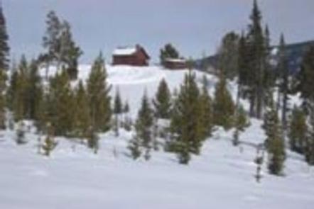
Little Bear Cabin was built in 1938 and still looks much the same as it did back then. It is available year-round for recreationists, as well as for those who seek a quiet mountain retreat. The cabin can be accessed by vehicle during the summer and fall (June 16th – December 31st) weather and snow conditions permitting, but winter access requires snowmobiling or skiing 10 miles from the paved road. Guests are responsible for their own travel arrangements and safety, and must bring several of their own amenities.
Recreation
Several multi-use trails and roads crisscross the area, ideal for motorcycle and off-road vehicle riding, mountain biking and hiking. Winter activities include snowshoeing,snowmobiling and cross-country skiing. The area surrounding the cabin is popular with hunters in the fall.
Facilities
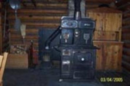
The cabin has a bunk bed downstairs and two beds in the loft, each with mattresses, to sleep up to four people. There is a wood cook stove which provides some heat, but it may not be sufficient in extremely cold temperatures. A table with chairs, broom,dustpan and snow shovel are provided. A campfire ring and outhouse with vault toilet are located outside the cabin.Water and electricity are not available. Guests must bring their own drinking water, as well as fire starters (matches and newspaper), bedding, dish soap, flashlights or lanterns and extra toilet paper, among other necessities. The cabin must be cleaned and all trash removed prior to leaving.
Natural Features
The cabin sits atop a grassy knoll on a small ridge near the north end of the Gallatin Range, offering views of Gallatin Valley and the Bridger Range. Stands of mixed conifer surround the cabin. Wildlife in the surrounding area includes grizzly and black bears, gray wolves, mountain lions, deer, elk, moose, bighorn sheep and Canada lynx. Birders may see a wide variety of bird species.