


Directions
From Columbia Falls, take Nucleus Avenue north through Columbia Falls and turn east on Railroad Street. At the stop sign, the road becomes the North Fork Road. Continue on North Fork Road for about 45 miles and over the railroad overpass. Turn left (west) on Whale Creek Road 318 and drive 4 miles, then turn right on the narrow Hornet Road 9805 and go 5.2 miles to the trailhead of Hornet Trail 349. Hike about a mile to the lookout.
Phone
406-387-3800
Activities
HISTORIC & CULTURAL SITE, CAMPING, HIKING, WILDLIFE VIEWING
Keywords
HORN,HORNET,LOOKOUT,FLATHEAD NF – FS
Related Link(s)
Overview
Hornet Lookout provides guests with astounding 360-degree views of the surrounding terrain, including Glacier National Park and Kintla Lake on clear days. On some nights, the Northern Lights may be seen from the lookout. Visitors also enjoy access to a variety of recreational activities.
Access to the lookout requires a one-mile hike from the trailhead at the parking area. Guests are responsible for their own travel arrangements and safety, and must bring several of their own amenities.
Recreation
Hiking and mountain biking on the gravel roads and trails are among the activities available in the area. Viewing wildlife is another rewarding pastime.
Facilities
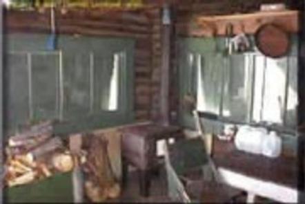
The two-story lookout sits at ground level. The ground level provides a living space for two guests and the second story is a small loft used solely for full views of the region. The lookout’s rustic accommodations include a propane cook stove, propane lantern, two cots, a small wood stove for heat. A pit toilet is provided outside the lookout. Pets are allowed, but cleaning up after them is required.
No water is available. Guests should pack their own bedding, water, first aid kit and food, among other necessities. Click here for more cabin details.
Natural Features
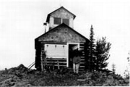
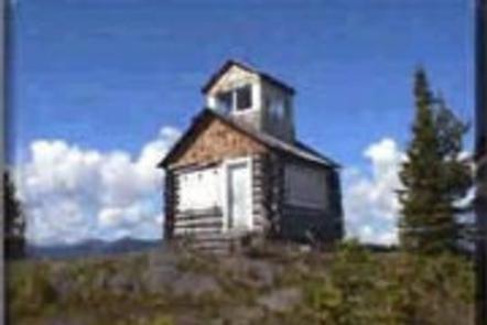
The scenic lookout is perched atop Hornet Peak, at an elevation of 6,744 feet. Nearby peaks include Wedge Mountain and Akinkoka Peak. The rustic lookout was built in 1922 and, in its prime, played an integral role for detecting forest fires in the North Fork area. A 2003 wildfire charred the surrounding area, but wildflowers and bear grass are making a comeback.
Glacier View Ranger District is bordered on the east by the North Fork of the Flathead River and Glacier National Park. To the north is Canada and west is the Montana’s Kootenai National Forest.
Nearby Attractions
Glacier National Park and the Wild and Scenic North Fork of the Flathead River are nearby.