STEEL CREEK GROUP CAMPGROUND, ID Campground Reservation, Info, Images, Map, Directions

STEEL CREEK GROUP CAMPGROUND, Idaho Campground Images, Info & Reservations

Directions

From Dubois, Idaho: Travel north on I-15 to the Stoddard Creek Exit (Exit 184). Go east on West Camas-Miners Creek Road (FR 006) for approximately 14 miles to Steel Creek Road (FR 478), turn right and continue 0.75 miles to the campground entrance.

From the Kilgore Store: Travel west/northwest approximately 8.25 miles on the West Camas-Miners Creek Road (FR 006) to Steel Creek Road (FR 478), turn left and continue 0.75 miles to the campground entrance.

Phone

208-270-0094

Activities

BIKING, CAMPING, FISHING, HIKING, HUNTING, WILDLIFE VIEWING, DAY USE AREA

Keywords

STEE,CARIBOU-TARGHEE NF – FS

Related Link(s)

Rec Area Info & Images

Idaho State Road Conditions

Idaho State Tourism

Overview

Steel Creek Group Campground is located 35 miles northeast of the town of Dubois, Idaho, and 9 miles northwest of Kilgore. Visitors come to the area to enjoy the abundance of trails, wildlife viewing opportunities and scenic beauty.

Recreation

Hiking, hunting, fishing, mountain biking and ATV riding are popular activities in area.

Facilities

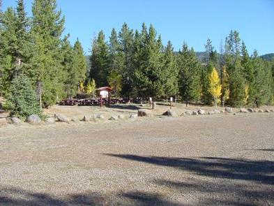
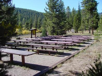
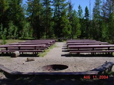
The campground contains one large accessible group site that can accommodate up to 200 people. A common parking area is adjacent to the dining area. Picnic and serving tables, a grill and campfire circle are provided, as are vault toilets and drinking water.

Natural Features

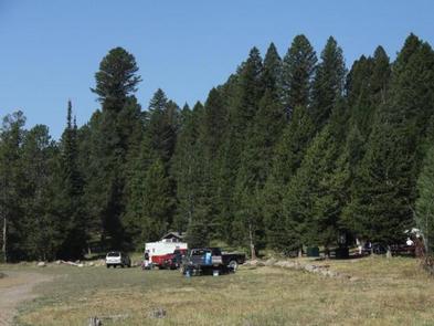
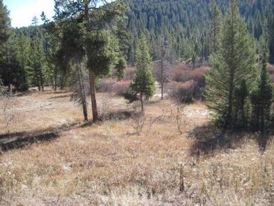
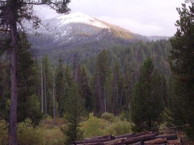
The campground offers picturesque views of the surrounding mountains and is situated among willow and pine trees adjacent to a small stream. A variety of wildlife makes its home around the campground.

Nearby Attractions

Phone, gas, and groceries are available in Dubois, Idaho. Minimal services are available in Kilgore, Idaho at the quaint Kilgore Store.

Reservation

More from CampingHiking.net:

BLACKHAWK, Utah Campground Images, Info & Reservations

Directions From I-15, take exit 250 toward North Payson/Salem and proceed south on Main Street, then turn east onto 100 North/Highway. Turn south onto 600 East, which becomes the Nebo Loop Scenic Byway/Payson Canyon Road. Travel up the canyon to the campground. Phone SPANISH FORK RANGER DISTRICT 801-798-3571 OR UTAH

SOUTH PIKE BAY, Minnesota Campground Images, Info & Reservations

Directions From Cass Lake, Minn., travel 3 miles south on Highway 371. Turn east onto Forest Road 2137 and travel 2 miles to the campground. Phone 218-547-1044 Activities BIKING, BOATING, HISTORIC & CULTURAL SITE, CAMPING, FISHING, WATER SPORTS, SWIMMING SITE Keywords SPKB,Pike Bay Related Link(s) Rec Area Info & Images

JOHNSON CREEK DAY USE, Texas Campground Images, Info & Reservations

Directions From Jefferson, Texas, travel 3.8 miles northwest on Highway 49. Turn left onto FM 729 and continue for just over 8.5 miles. Park entrance will be on the left. Phone 903-665-2336 Activities BOATING, FISHING, PICNICKING, WATER SPORTS, WILDLIFE VIEWING, DAY USE AREA, SWIMMING Keywords None Related Link(s) Rec Area

EAST LAKE CAMPGROUND, Oregon Campground Images, Info & Reservations

Directions From Bend, travel 23.5 miles south on Hwy 97, then 16.6 miles east on Road 21. Phone 541-383-5300 Activities CAMPING Keywords Related Link(s) Rec Area Info & Images Oregon State Road Conditions Oregon State Tourism Overview East Lake Campground sits at the edge of beautiful East Lake in the

TANNERY, California Campground Images, Info & Reservations

Directions Take I-5 to Redding, take 299 west to Weaverville, take a right on Highway 3 and go about 11 miles. The campground sign is on the left, but turn right to enter. Take 101 to Eureka, take 299 east to Weaverville, take a left on Highway 3 and go