
Directions
From Dillon, travel north on I-15 for 12 miles to exit 74 at Apex. Turn west and continue about 8 miles on Birch Creek Road. Cross the bridge and take the first right onto Thief Creek Road. The cabin is about 1/4-mile to the west at Thief Creek. Depending on snow conditions, guests may need to park at the Birch Creek Road turnoff and ski or snowmobile to the cabin. Maps may be purchased at the Dillon Ranger District or online http://www.fs.usda.gov/bdnf (mobile maps are available).
Phone
406-683-3900
Activities
BIKING, BOATING, HISTORIC & CULTURAL SITE, CAMPING, HIKING, HUNTING, WINTER SPORTS, WILDLIFE VIEWING
Keywords
BCCA,BEAVERHEAD-DEERLODGE NF -FS
Related Link(s)
Overview
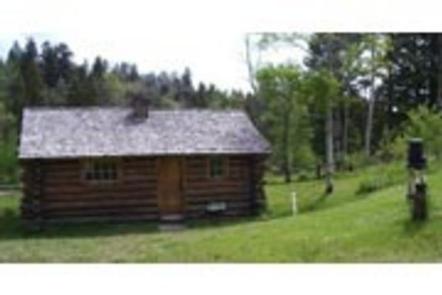
Birch Creek Cabin is a historic log cabin with electricity and running water. It provides access to a variety of hiking, ohv, and for cross-country skiing and snowshoe trails (depending on the season). A vaulted toilet lies 100′ west of the cabin. Guests can typically access the cabin by vehicle, depending on conditions. The roads leading to the cabin are gravel – but suitable for passenger cars (depending on the season and snow levels). The final quarter-mile may be covered with impassible snow during the winter, requiring skis, snowshoes or snowmobile to complete the route. There is a reliable parking area just off of the Birch Creek Road near the Thief Creek Bridge. Guests are responsible for their own travel arrangements and safety, and must bring several of their own amenities.
Recreation
An extensive network of hiking trails exists on the surrounding peaks and valleys. Some lead to alpine lakes, which offer quality mountain fishing. Grayling, cutthroat trout, brook trout and rainbow trout can all be found in the mountain waters. There are two popular cross-country skiing and snowshoeing trails adjacent to the cabin. The Birch Creek Loop and the May Lake Ski Trail both traverse through the area. Old mining roads are plentiful in the area, providing excellent opportunities for exploration on foot, bike, ohv or horseback.
Facilities
The two-room log cabin is equipped with bunkbeds and mattress pads that will sleep up to four people. A separate kitchen has a table and chairs, an electric cook stove, pots and pans and basic eating and cooking utensils. A wood stove is available inside the cabin for heat and firewood is provided. An outhouse with a vault toilet is available outside the cabin. Drinking water is provided, but is not available year-round. Guests will need to bring their own bedding, including blankets and pillows, as well as matches, food, toilet paper, garbage bags and other necessities. Wood may be available, but the supply cannot be guaranteed. Those staying at the cabin during the winter months will need to bring their own water for drinking, cooking and cleaning purposes. Guests are asked to be conservative with wood and propane fuel used to light the cabin, as well as clean the cabin and carry out all trash upon departure. There is no cell phone reception at the cabin. Limited cell phone coverage may be obtained near the Forest Boundary to the east (carrier dependent).
Natural Features
The cabin sits below a historic Civilian Conservation Corps work camp at the confluence of Birch Creek and Thief Creek. It is situated on the eastern slopes of the Pioneer Mountains in southwestern Montana, and was used as a forest ranger station as early as 1908. A forested picnic area is nearby. An abundance of wildlife live in the area, including elk, moose, deer, pine marten, wolverine, northern goshawk, wolf, black bear and (rarely) grizzly bear.
Nearby Attractions
Farlin Mining Community, Torrey Mountain, Tweedy Mountain, Thief Creek Road (passable in summer and fall), Aspen Picnic Area, Dinner Station Campground, Bond Lake Trailhead, Deerhead Lake Trailhead, Minneopa Trailhead. From Willow Creek Road – Gorge Lake Trailhead, Torrey Lake Trailhead, Rainbow Lake Trailheads