

Directions
From Big Timber, Montana, travel 16 miles south on Highway 298 to McLeod. Just past the turn off to McLeod, turn right (west) onto West Boulder Road for approximately 6 miles. It turns into Swingley Road. Drive on Swingley Road for 1.5 miles, then turn left onto West Boulder Road. The cabin is between West Boulder Campground and the trailhead parking area. During winter months, it is advisable to call the Livingston Office of the Yellowstone Ranger District at (406) 222-1892 for local road conditions. Winter access may only be possible by snowmobile, snowshoes or cross-country skis for up to a mile on county road.
Phone
406-222-1892
Activities
CAMPING, FISHING, HIKING, WINTER SPORTS
Keywords
WESB,WEST,BOULDER,GALLATIN NF – FS
Related Link(s)
Overview
West Boulder Cabin is open year-round, offering a variety of recreational opportunities as well as relaxation. Guests can drive to the cabin in warmer weather but should be prepared to snowshoe, ski or snowmobile up to a mile on county roads in the winter.
The cabin has electric lights and an electric cook stove. A refrigerator is no longer available. Rental camping equipment, such as ice chests, bear spray, campstoves, etc., are available locally in Bozeman. Guests will need to bring many of their own supplies to ensure a comfortable stay.
Recreation
Hikers and equestrians can find trails leading west into the Absaroka Mountains which connect to a network of trails in the Absaroka-Beartooth Wilderness. The winter landscape is ideal for cross-country skiing and snowshoeing.
Anglers can fish for Yellowstone cutthroat and rainbow trout in the West Boulder River.
Facilities
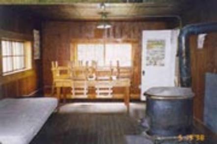
This three-room cabin has electric lights, and an electric cook stove. Amenities include five single beds with mattresses, a table with chairs, basic cookware and utensils, some cleaning gear, an axe, maul, bucket and shovel. A wood-burning stove is provided for heat.
FIREWOOD IS NOT AVAILABLE FROM JUNE 1ST THROUGH SEPTEMBER 30TH. PLEASE BRING FIREWOOD OR GATHER FROM FOREST DURING SUMMER. Firewood is available for INDOOR use only during winter as long as supplies last.
There is a campfire ring and a vault toilet outside. Firewood is provided for use in the wood heating stove only. DO NOT BURN PROVIDED WOOD OUTSIDE AS IT IS EXTREMELY DIFFICULT TO REPLACE AND IS NEEDED FOR WINTER USERS INDOORS. Guests must bring their own wood or collect wood from the nearby forest for campfires.
Water is not available at the cabin, but potable water is available FROM APPROXIMATELY MEMORIAL DAY THROUGH LABOR DAY at the adjacent West Boulder Campground. Guests must bring their own drinking water the remainder of the year or treat water from the river to use for drinking and cooking.
Guests are expected to clean the cabin and pack out their trash before leaving. Garbage bags are not provided. Visitors should plan to bring items like a flashlight, bedding, cookware, dishes, utensils, newspaper, matches, toilet paper and first aid kit.
Natural Features
West Boulder Cabin sits at an elevation of 5,538 feet on the edge of a meadow near the mouth of the West Boulder River Canyon. The cabin is just steps away from the river and adjacent to the Absaroka-Beartooth Wilderness. Aspen and lodgepole pine forest and the snow-speckled peaks of the Absarokas mark the surrounding landscape.
This area is home to moose, mule deer, elk and grizzly bear. Birders may spot bald eagles, owls, Stellar’s jays, western meadowlarks and mountain bluebirds.