


Directions
Pebble Guard Station is located about 16 miles north of Lava Hot Springs, Idaho. Just east of Lava Hot Springs, look for the "Pebble Area" sign and turn left (north) onto Blaser Highway/Old Highway 30. Go north on the paved highway for 9 miles to Pebble Creek Road (known locally as Mike’s Place or Whiskey Mike’s). Turn left (west), across railroad tracks on gravel Forest Road 036. Travel 6.5 miles to the guard station. Big Springs Campground is 1/2-mile beyond the cabin.
Phone
208-236-7500
Activities
BIKING, CAMPING, HIKING, HORSEBACK RIDING, HUNTING, WINTER SPORTS
Keywords
PBGS,CARIBOU-TARGHEE NF – FS
Related Link(s)
Overview
Pebble Guard Station is located at the base of Bonneville Peak along beautiful Pebble Creek, a tributary of the Portneuf River. The rustic one-room cabin offers a secluded retreat on four fenced acres, surrounded by high mountain vistas.
The original Pebble Guard Station was built in 1908. The current structure stands at a higher altitude and was built in 1933.
Guests can drive to Pebble Guard Station during warmer months, but it can only be accessed by snowmobile in winter. Those arriving in winter should expect to haul their gear and supplies for about 4 miles on a groomed trail. The cabin supplies most of the comforts of home, especially during the warmer months, but guests may need to bring some additional items.
Recreation
Guests at Pebble Guard Station will find opportunities for recreation year-round. Hunting is a popular pastime, and a nearby beaver pond provides good fishing and wading. Trails for hiking, mountain biking, horseback riding and off-road vehicles are nearby (Idaho OHV safety message). In winter, the area turns into a snowmobiling playground.
Facilities
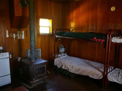
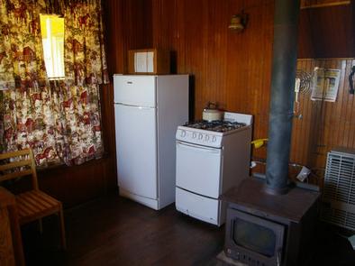
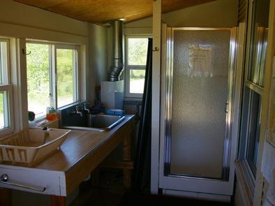
The guard station offers a mudroom/porch with a large sink, countertop and shower facilities. The main room serves as the kitchen and sleeping room. Cabin amenities include a wood stove for heat, propane appliances (heater, stove/oven, water heater), two bunk beds with mattresses, two folding cots, limited tableware and cookware, four chairs and a fold-down table.
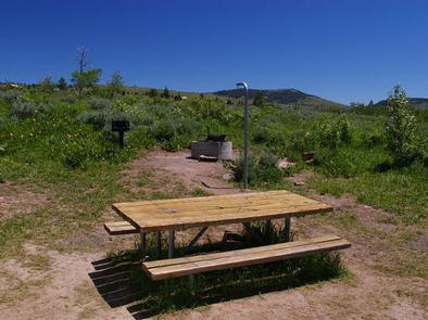
A vault toilet, horse corral, campfire ring, grill and picnic table are located outside. Fire ring is available seasonally and is stacked next to the cabin. The parking area can accommodate up to four RVs.
The cabin’s water is shut off Oct. 10th, depending on weather, so winter guests need to bring their own water. Bedding, cleaning supplies, towels, garbage bags, first aid supplies, matches and flashlights are not provided. Guests are expected to clean the cabin and pack out their trash upon departure.
Natural Features
The cabin is located at 6,320 feet on the open foothills of Pebble Basin, which offers expansive views into the high country of Bonneville Peak. This peak is the highest of the Portneuf Range, and the mountains of this range are covered with pine forest and green vegetation.
A variety of wildlife inhabits this area, including mule deer, elk, cougars, coyote and black bears (bear safety tips).
Nearby Attractions
Lava Hot Springs makes a fun day trip from the cabin. Visitors can enjoy a natural hot springs soaking pool, Olympic-sized swimming pool, waterslides and diving platforms. Two 9-hole disc golf courses are linked around the Lava Hot Springs pool complex.
Tubing on the Portneuf River is also a very popular activity. Tube rentals are available throughout town.