DILLON CREEK CAMPGROUND, CA Campground Reservation, Info, Images, Map, Directions

DILLON CREEK CAMPGROUND, California Campground Images, Info & Reservations

Directions

From State Route 299 in Willow Creek, take State Route 96 north for 60.2 miles. The campground will be on the left side.

From Interstate 5 in northern California, take State Route 96 southwest, past Happy Camp, for 85.7 miles. The campground will be on the right side.

Phone

530-629-4136

Activities

BOATING, CAMPING, FISHING, HIKING, WILDLIFE VIEWING

Keywords

DILLON CREEK CAMPGROUND (CA)

Related Link(s)

Rec Area Info & Images

California State Road Conditions

California State Tourism

Overview

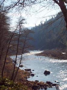
Dillon Creek Campground sits along its namesake creek in the lush forests of northern California. Visitors enjoy a variety of water sports on the nearby Klamath River.

Recreation

The Klamath and Salmon Rivers offer excellent fishing, swimming and whitewater rafting opportunities. Fishing for salmon and steelhead during the fall and early winter months is considered the finest in California. Hunting is also a popular pastime, with game including blacktail deer, black bear, blue grouse and quail.

Facilities

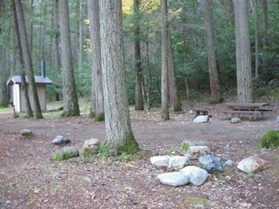
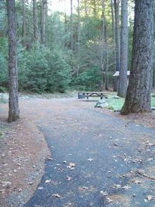
This campground has several single-family campsites, all equipped with picnic tables and campfire rings with grills. Vault toilets and drinking water are provided. A host may be on-site, and roads throughout the campground are paved.

Natural Features

The campground is situated in a forest of mixed hardwoods and conifers at an elevation of 1,780 feet. The Klamath River, a popular site for salmon fishing, runs alongside the site.

Reservation

More from CampingHiking.net:

LINK CREEK, Oregon Campground Images, Info & Reservations

Directions Travel approximately 13 miles northwest of Sisters on Highway 20/126. Turn left onto Forest Road 2070/Suttle Lake Campgrounds. Travel less than 1/2 mile to Blue Bay entrance on the right to Link Creek. Phone 541-323-1746 Activities BOATING, CAMPING, FISHING Keywords LINK,SUTTLE LAKE CAMPGROUND,DESCHUTES NF – FS Related Link(s) Rec

SPEEGLEVILLE PARK, Texas Campground Images, Info & Reservations

Directions From I-35, take exit 330B Hwy 6 N toward Meridian for about 6 miles. After passing over the Lake on the Twin Bridges, take the first exit toward Lake Waco/Speegleville Park. Take a left on the access road. You will continue past the Twin Bridges Park about a quarter

PAYSON LAKES, Utah Campground Images, Info & Reservations

Directions From I-15, take exit 250 toward north Payson/Salem and proceed south on Main Street to 100 North/Highway 198. Travel east to 600 East. Turn south onto 600 east, which becomes the Nebo Loop Scenic Byway/Payson Canyon Road. Travel up the canyon to the campground. Phone SPANISH FORK RANGER DISTRICT

MUDDY GUARD CABIN, Wyoming Campground Images, Info & Reservations

Directions From Buffalo, Wyoming, take Wyoming State Highway 16 west 24 miles. Turn left on Crazy Woman Road (FSR 33), travel 400 feet, turn right on Forest Service Road 473. Visitors will use a gate to access the cabin. Please keep the gate closed. Phone 307-684-7806 Activities BIKING, BOATING, CAMPING,