Kinnikinnick (Laurance Lake) Campground, OR Campground Reservation, Info, Images, Map, Directions

Kinnikinnick (Laurance Lake) Campground, Oregon Campground Images, Info & Reservations

Listen

Directions

From I-84 in Hood River – South on highway 35 to Parkdale. Follow signs to Laurance Lake.

Phone

541-386-6366

Activities

BIKING, CAMPING, FISHING, FISH HATCHERY

Keywords

Laurance Lake Campground

Related Link(s)

Rec Area Info & Images

Oregon State Road Conditions

Oregon State Tourism

Overview

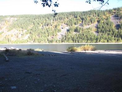
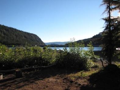
Kinnikinnick Campground is a hidden gem, situated north of Mt. Hood, just outside of Parkdale, Oregon. Sitting on Laurence Lake, Kinnikinnick Campground offers beautifully landscaped campsites with views of Laurence Lake and the wide-open hills that surround the lake.

Recreation

Laurence Lake allows all non-motorized water sports. There are no rental facilities on site.

Facilities

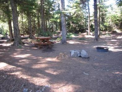
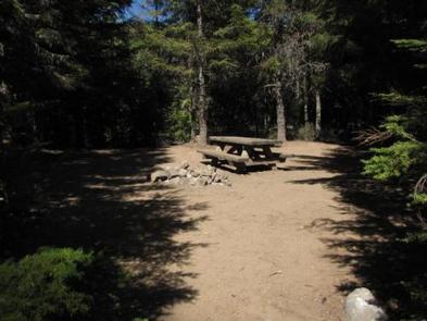
The campground features well-groomed campsites, including campfire pits and picnic tables. The location offers vault toilets. There is a boat ramp nearby.

Natural Features

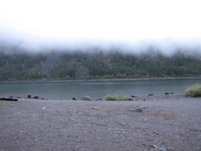
Surrounded by Laurence Lake, Kinnikinnick Campground is a natural attraction all its own. With incredible lake views, regular sightings of bald eagles and rock and hill formations that surround this site, it is the perfect place to go "off the grid" and enjoy the outdoors.

Nearby Attractions

Laurance Lake is great for waterplay and fishing. Kinnickinnick Campground is just a 30-minute drive to nearby ski resorts, where summer hiking and outdoor adventures await.

Reservation

More from CampingHiking.net:

AL TAYLOR CABIN, Idaho Campground Images, Info & Reservations

Listen Directions The cabin can be accessed by traveling west from Kilgore, Idaho, via Forest Road 006 approximately 8 miles to Forest Road 478. Travel Forest Road 478 to the Steel Creek Group Area. The cabin is located just outside of the group area and can be reached by driving

WILLOW PRAIRIE HORSECAMP, Oregon Campground Images, Info & Reservations

Listen Directions From Butte Falls, take County Road 821 (Butte Falls-Fish Lake Highway) approximately 17 miles southeast to Forest Road 3738. Turn west (right) on Forest Road 3738 and drive 1.3 miles to where Forest Road 3738 intersects Forest Road 3735. Turn left onto Forest Road 3735 and you will

MOUNT ROSE (NV), California Campground Images, Info & Reservations

Listen Directions From Highway 395 south of Reno, travel 17 miles west on State Route 431, following signs to the campground. The Actual Mailing Address is: PO Box 104, Markleeville, CA 96120. The Physical Address is: Mt. Rose Hwy, State Route 431, Reno, NV 89511. Phone 530-694-1002 Activities BIKING, CLIMBING,

GAMALIEL, Arkansas Campground Images, Info & Reservations

Listen Directions From Mountain Home, AR, travel 9 miles east on US 412/62, then 5 miles north on SR 101, then 3 miles southeast on CR 42. Follow signs into campground. Phone 870-467-5680 Activities BOATING, CAMPING, SWIMMING SITE Keywords GAMA,NORFORK LAKE,NORFORK LAKE Related Link(s) Rec Area Info & Images Arkansas

INDIAN CREEK CAMPGROUND (CA), Nevada Campground Images, Info & Reservations

Listen Directions From Woodfords, California, travel Hwy 89 south approximately four (4) miles to Airport Road. Turn left or east on Airport Road and travel another four miles on paved surface to the campground entrance located just south of Indian Creek Reservoir. Phone (775) 885-6000 Activities AUTO TOURING, BIKING, BOATING,

PHOCENA BAY CABIN, Alaska Campground Images, Info & Reservations

Listen Directions Approximately 15 air miles and 25 water miles from Ketchikan on the south shore of Phocena Bay on the west side of Gravina Island. Accessible by floatplane or by boat. A mooring buoy is located in Phocena Bay. Refer to USGS Ketchikan A-6. Please consult local tide tables