

Directions
From Globe, head north on Highway 60 toward Showlow for about 20 miles. The campground is adjacent to Highway 60 and south of the Seneca Lake Recreation Area.
Phone
928-402-6200
Activities
CAMPING, HIKING, HORSEBACK RIDING, WATER SPORTS
Keywords
Timber Camp,Timber Camp Horse Camp,Timber Creek Equestrian Site
Related Link(s)
Overview
Timber Camp Recreation Area has one of the most popular family and group campgrounds in the Tonto National Forest offering both day-use sites and over-night areas.
Recreation
Abundant recreation opportunities such as cross-country horseback riding, hiking, in-season hunting, exploring, off-highway vehicle use and wildlife viewing are in close proximity. In the spring, whitewater rafting trips on the Upper Salt River launch a mere 20-minute drive from the site. Brundrett 2 and the equestrian sites are excellent places to stage authorized outdoor group events (a separate permit may be required). While there are no dedicated equestrian trails, the surrounding terrain is ideal for cross-country horseback riding.
Facilities
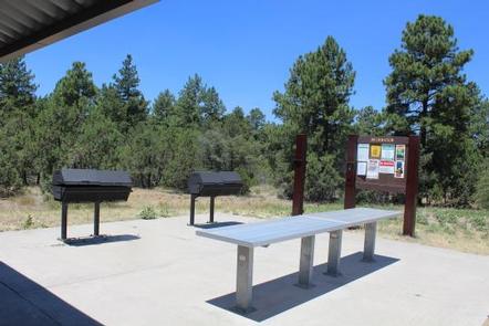
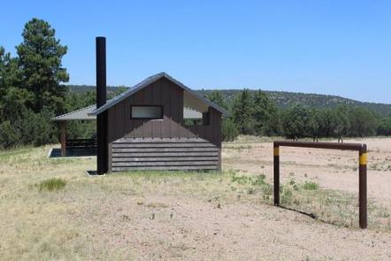
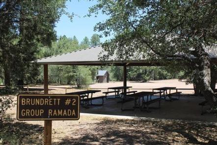
Brundrett 2 is a group camping area available for advanced reservations for overnight and day use. The stay limit is 14 days, and trailers must be less than 45 feet. Brundrett 2 accommodates up to 150 people maximum and offers a large open gravel lot providing ample space for group activities. There is an open parking area for approximately 15 RVs or 25 passenger vehicles. Accessible vault toilets, campfire rings, grills, a pavilion and tables are provided.
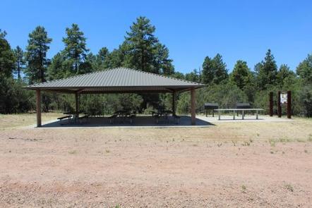
The equestrian site is available for advanced reservations for overnight and day use. This is a Non Electric site. Non-equestrian use is permitted. The stay limit is 14 days, and trailers must be less than 45 feet. There is a 150 person maximum for this group site. The facility offers steel corrals, two hitching rails, manure bins and open parking for about 25 vehicles pulling trailers up to 45 feet. In addition, the area includes a large group gathering area with pavilion with picnic tables, group cooking grill and serving tables. The group site is fenced, and the front entrance gated.
Brundrett 1 is a first-come, first-served camping area with 13 individual campsites (12 single occupancy, 1 double occupancy) and a fee payable on site. This area has a large shade pavilion, picnic tables, fire grills and rings and two accessible vault toilets.
There is a first-come, first-served day use facility located nearby.
Natural Features
Located within the Timber Camp Mountains and surrounded by a ponderosa pine and juniper woodland, this area offers a cool get away from the hot summer months. Five miles east of the site, the area eventually meets the ledges and beautiful vistas of the Salt River Canyon and the Salt River Canyon Wilderness.
Nearby Attractions
Approximately 10 miles north along Highway 60, on White Mountain Apache Tribal Lands, lies Seneca Lake and Falls, a popular recreation area for sightseeing and fishing (WMAT permit required). As you continue further north along Highway 60, the road cascades down into the Salt River Canyon where several overlooks allow you to capture the magnificent beauty of "Arizona’s other Grand Canyon". Only 24 miles south from Timber Camp, the City of Globe offers an array of restaurants, as well as antique, grocery, and feed and tack stores.