HORSE CAMP PRIMITIVE CAMPGROUND, CA Campground Reservation, Info, Images, Map, Directions

HORSE CAMP PRIMITIVE CAMPGROUND, California Campground Images, Info & Reservations

Directions

From Interstate 5 in Redding, CA, drive 10 miles west on Highway 299. Turn left on Kennedy Memorial Drive at the visitor center and follow it for 1.6 miles until you reach a fork in the road at the dam. Turn left on Paige Bar Road and drive for two miles until you reach another fork in the road at the NEED Camp. Turn left onto the gravel road and proceed .5 miles to Horse Camp.

Phone

530-242-3412

Activities

CAMPING, HIKING, HORSEBACK RIDING, HUNTING, MOUNTAIN BIKING, GOLD PANNING

Keywords

Related Link(s)

Rec Area Info & Images

California State Road Conditions

California State Tourism

Overview

This campground is located in the southeast corner of Whiskeytown National Recreation Area, 15 miles west of Redding, California, and three and a half hours north of Sacramento. This is the only campground in the park that can accommodate camping with horses, but horseback riders must share the campground with visitors who may not have horses.

The cool, clear waters of Whiskeytown Lake provide endless water activities. The picturesque mountain setting and extensive forested backcountry offer ample opportunities for horseback riding, hiking and biking.

Recreation

During the summer heat, swimming, kayaking, sailing, paddle boarding and water skiing are popular on the 3,200 acre lake. Year round, hiking, mountain biking, horseback riding, gold panning, fishing and picnicking attract visitors. Hunting is allowed in the appropriate season.

Facilities

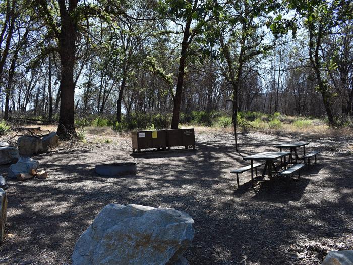
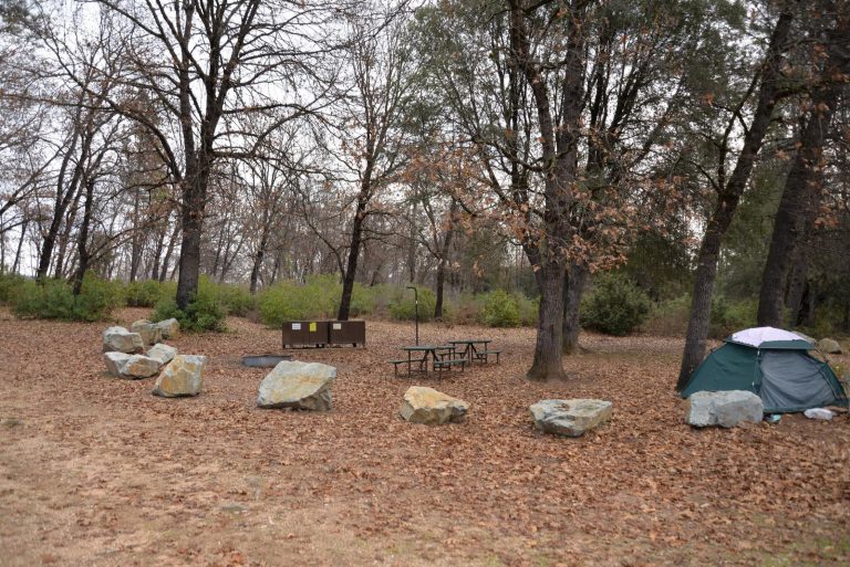
Horse Camp can accommodate any vehicle or combination of vehicles, including trailers, RVs and RVs pulling other vehicles. Overflow parking is available. Each campsite is equipped with two picnic tables, two large bear-resistant storage lockers, a metal fire pit with a swing-arm barbecue grill and a lamp pole. The two campsites share a vault toilet. A hand pump provides potable water when available. There is no electricity at the site.

There are no corrals, hitching posts or troughs at the site. Horses must be high-lined or tethered to trailer.

Natural Features

Whiskeytown National Recreation Area is located where the Klamath Mountains, Cascade and Coast Mountain Ranges, and the Sacramento Valley meet, creating a wide variety of wildlife and landscapes. Foothill pines lightly shade Horse Camp.

Nearby Attractions

Brandy Creek Beach is located five and a half miles from the campground and features sandy beaches, a large swimming area, picnicking and barbecuing facilities. From Memorial Day through Labor Day, there are showers, a store with food and supplies and rentals of paddle boards and kayaks.

Reservation

More from CampingHiking.net:

PARKER CREEK, Arkansas Campground Images, Info & Reservations

Directions From Texarkana, Arkansas, take Interstate 30 east for 46 miles to Prescott. Continue onto Highway 19 north to Narrows Dam. After crossing the bridge across the Little Missouri River, proceed about 3 miles to the campground. Phone 870-285-2151 Activities BOATING, CAMPING, FISHING, HIKING, HUNTING, SWIMMING SITE Keywords PARR,Couch Valley,LAKE

PLOTNIKOF LAKE CABIN, Alaska Campground Images, Info & Reservations

Directions Accessible early June through October. This cabin is located 45 miles southeast of Sitka, 4 miles east of Whale Bay, on the south-central part of Baranof Island. Access by floatplane is 40 minutes from Sitka. For geographic features surrounding the cabin, refer to USGS topographic map Port Alexander C-3.

BLACK CANYON CAMPGROUND, Oregon Campground Images, Info & Reservations

Directions From Oakridge, Oregon, follow Highway 58 west about 8 miles to Black Canyon Campground, located 1 mile east of Lookout Point Reservoir. Phone 801-226-3564 Activities BIKING, BOATING, FISHING, KAYAKING Keywords BCAN,WILLAMETTE NF -FS Related Link(s) Rec Area Info & Images Oregon State Road Conditions Oregon State Tourism Forest Service

DEEP CREEK PICNIC PAVILION, North Carolina Campground Images, Info & Reservations

Directions Seasonal phone is 828-488-3184 From downtown Bryson City, NC: Follow signs to Deep Creek, 3 miles away. Phone 865-436-1261 Activities HISTORIC & CULTURAL SITE, CAMPING, FISHING, HIKING, HORSEBACK RIDING, VISITOR CENTER, WILDLIFE VIEWING Keywords Great Smoky Mountains National Park,Great Smokey Mountains National Park,Great Smoky Mountain National Park Related Link(s)

OAK FLAT LOOKOUT, California Campground Images, Info & Reservations

Directions From Bakersfield, California, take Highway 99 to Highway 178 and travel east towards the Kern River Canyon. After passing through the last traffic light (Miramonte Drive) east of town, you will travel downhill. Rancheria Road will be the next left turn off the highway. Proceed 15 miles north along

MOUNT FLEMER CABIN, Alaska Campground Images, Info & Reservations

Directions The cabin is located on the south shore of the Stikine River within the Stikine-LeConte Wilderness. It is two miles downriver from the border between the United States and Canada. Distance from Wrangell is 32 miles by shallow draft boat. Low river levels can affect access; consult local tide