COLD SPRINGS CAMPGROUND (OR), OR Campground Reservation, Info, Images, Map, Directions

COLD SPRINGS CAMPGROUND (OR), Oregon Campground Images, Info & Reservations

Listen

Directions

From Sisters, OR: Travel 4.2 miles west on Highway 242 (McKenzie Pass Highway).

Phone

541-323-1746

Activities

CAMPING

Keywords

Related Link(s)

Rec Area Info & Images

Oregon State Tourism

Oregon State Road Conditions

Overview

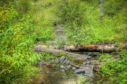
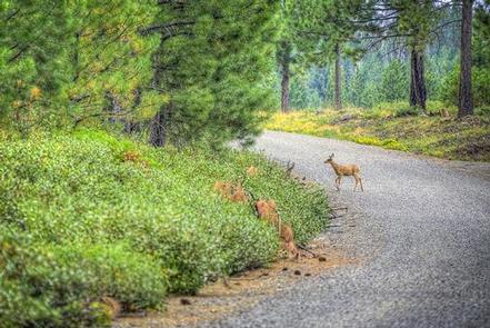
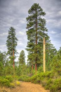
A pleasant, small spring runs through the center of this popular, shaded campground. Located just southwest of Sisters, Oregon, Cold Springs Campground is nestled below a thick Ponderosa Pine forest mixed with aspen in the wet areas. This campground offers opportunities for hiking and bird watching and is a great option for the whole family.

Recreation

This campground offers many opportunities for hiking and biking with the many trails nearby. The ponderosa pine forest provides shade as well as the chance to go bird or nature watching.

Facilities

There are 23 single campsites in this facility. Water is available by hand pump and there are three vault style toilets. Each site is equipped with a picnic table and fire ring.

With a loop road, bicycling throughout the campground is a favorite pastime for families that come to Cold Springs Campground.

Natural Features

Nestled in the forest with a pleasant, small spring running through the center of this facility, Cold Springs Campground is a great shady family spot with short hikes all around.

Nearby Attractions

The close proximity to the town of Sisters offers many additional amenities and attractions, as well as the nearby Sisters Wilderness Trails.

Reservation

More from CampingHiking.net:

CHISHOLM TRAIL RIDGE, Oklahoma Campground Images, Info & Reservations

Listen Directions From Waurika, Oklahoma, take Highway 5 northwest for 5 miles. Turn right onto Advent Road and proceed 3 miles. Turn left on Chisholm Trail Road and drive one mile to the park entrance. Phone 580-439-8040 Activities BOATING, CAMPING, FISHING, SWIMMING SITE Keywords CHIS,WAURIKA LAKE,WAURIKA LAKE Related Link(s) Rec

BERRY MOUNTAIN PARK SHELTER, North Carolina Campground Images, Info & Reservations

Listen Directions From Charlotte, North Carolina, take I-77 North (approximately 60 miles) before merging onto Highway 421 North towards Wilkesboro/Boone. Continue to Exit 286B (approximately 20 miles), turn left onto Highway 268 and continue for approximately 4 miles. Berry Mountain Park will be on the right. From Winston-Salem, North Carolina,

PORCUPINE (ID), Utah Campground Images, Info & Reservations

Listen Directions From U.S. Highway 89, turn west onto St. Charles Canyon Road/Forest Road 412. Follow for approximately 7 miles to the campground on the left side of the road. Phone 541-351-1182 Activities BIKING, BOATING, HISTORIC & CULTURAL SITE, CAMPING, FISHING, HIKING, HORSEBACK RIDING, HUNTING, WATER SPORTS, WILDLIFE VIEWING, SWIMMING

CRESCENT, Georgia Campground Images, Info & Reservations

Listen Directions From Hartwell, Georgia, take Hwy 29 north for approximately 8 miles (you will cross into South Carolina). Turn left onto Ginn Road. Take the first left onto Campers Way and continue straight to the campground. From Anderson SC, take Hwy 29 South from Anderson, heading south towards Hartwell,

STONY FORK CAMPGROUND, Virginia Campground Images, Info & Reservations

Listen Directions From Wytheville, VA, follow I-77 north to Exit 47. Turn left onto Route 717 and drive 4 miles to Stony Fork Campground. Total travel distance is 10 miles. Phone 276-783-5196 Activities BIKING, CAMPING, FISHING, HUNTING, WILDLIFE VIEWING Keywords SFCA,GEORGE WASHINGTON/JEFFERSON NF-FS Related Link(s) Rec Area Info & Images

Fish Dam Creek Park, North Carolina Campground Images, Info & Reservations

Listen Directions From Charlotte, North Carolina , take I-77 North (approximately 60 miles) before merging onto Highway 421 North towards Wilkesboro/Boone. Continue to Exit 286B (approximately 20 miles), turn left onto Highway 268 and continue for approximately 3.5 miles. Turn right onto Reservoir Road. Continue on Reservoir Road across the