


Directions
From Mackay, Idaho, drive north on Highway 93 approximately 17 miles and take a left on the Trail Creek Road. Travel approximately 15 miles on the Trail Creek Road. This road starts as paved and turns to gravel at approximately 12 miles. Turn left at the Wild horse/Copper Basin turnoff, and continue on this road for approximately 2 miles and bear left on Road #135. This road continues for approximately 14 miles. The Copper Basin Guard Station is on the right at the intersection of Roads 135 and 138.
From Ketchum, Idaho, travel north east on the Trail Creek Road, #208, for approximately 23 miles. Turn right on at the Wildhorse/Copper Basin turnoff and continue on this road for approximately 2 miles. Bear left on Road #135. This road continues for approximately 14 miles. The Copper Basin Guard Station is on the right at the intersection of Roads #135 and #138.
Phone
208-588-3400
Activities
BIKING, CAMPING, FISHING, HIKING, HORSEBACK RIDING, HUNTING, WILDLIFE VIEWING
Keywords
Related Link(s)
Overview
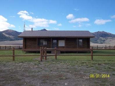
Copper Basin Guard Station is located in Copper Basin, a rugged and beautiful area in the Pioneer Mountains of south-central Idaho.
Recreation
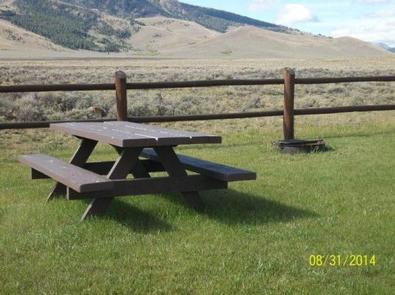
Copper Basin offers many recreational opportunities. These include stream and lake fishing, day hikes to high mountain lakes, mountain bike riding, hiking, horseback riding, camping, photography, hunting, off-highway vehicle (OHV) riding, birding, viewing wildlife, and driving for pleasure.
Facilities
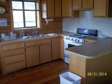
The Copper Basin Guard Station is a 900 square foot, two bedroom log cabin that can sleep up to six adults comfortably, with room for eight people total. The cabin comes furnished with one queen bed with mattress, two full sized bunk beds with mattresses, and a queen sized sleeper couch in the living room. Other amenities include a propane cook stove, propane refrigerator, propane furnace, propane lights, wood stove, table with benches and chairs, table settings for eight, kitchen tools and cleaning supplies. The bathroom has hot and cold running water, a flush toilet, and a shower.
The Copper Basin Guard Station has no electricity, phone service, cell coverage, or internet service. All appliances are powered by propane. Guests need to bring their own food, toiletries, towels, bedding and trash bags. There is no smoking, no candles, and no garbage service. No pets allowed in the cabin. Campfires are allowed only in the metal fire ring that is provided.
Natural Features
Copper Basin is a remote mountain valley with beautiful views, wide open spaces, and mountains in every direction. The Basin is surrounded by both the Pioneer and White Knob mountain ranges, with elevations between 7,500′ – 8,000′. Copper Basin has abundant wildlife, numerous streams, and stunning mountain peaks.
Nearby Attractions
Nearby attractions include fishing in the East Fork of the Big Lost River, OHV riding on the Lake Creek Trail, hiking on the Bellas Trail, and horseback riding on the Broad Canyon Trail.