COMERS ROCK PICNIC SHELTER, VA Campground Reservation, Info, Images, Map, Directions

COMERS ROCK PICNIC SHELTER, Virginia Campground Images, Info & Reservations

Listen

Directions

Comers Rock Picnic Shelter is located within Comers Rock Campground in Grayson/Wythe Counties, 21 miles southwest of Wytheville. From I-81 at Wytheville, take exit 67, 70, or 73 onto US 11 (Main Street). On the west end of town US 11 turns off, and Main Street becomes VA 21 south. Follow VA 21 south for 17 miles, then turn right onto gravel Forest Service Road 57 and follow it west for 4 miles to the campground.

Phone

276-783-5196

Activities

BIKING, BOATING, HISTORIC & CULTURAL SITE, CAMPING, FISHING, HIKING, HORSEBACK RIDING, HUNTING, WILDLIFE VIEWING

Keywords

Comers Rock Picnic Shelter,Comers Rock Campground

Related Link(s)

Rec Area Info & Images

Virginia State Tourism

Virginia State Road Conditions

Overview

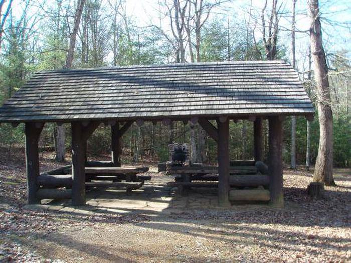
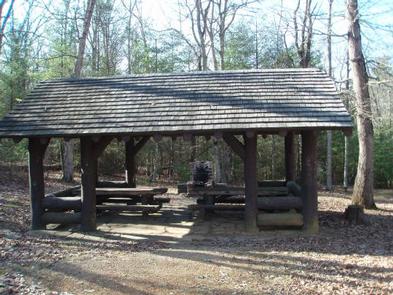
This historic log picnic shelter was built by the Civilian Conservation Corps. It is located next to Comers Rock Campground in the heart of the Mount Rogers National Recreation Area.

Recreation

There are primitive campsites available in the adjoing campground for $5.00 per night (first-come, first-served) and vault toilets are available. There are hiking trails in the area, including into Dry Run Wilderness, which is within walking distance from the campground and shelter.

Facilities

There are vault toilets and drinking water available. There are picnic tables and a large fire place. Parking is available.

Natural Features

Hale Lake is nearby for fishing, or stop at Comers Rock Overlook for breath taking long distance views of the valley.

Nearby Attractions

Hale Lake for fishing and Comers Rock Overlook for wonderful views.

Reservation

More from CampingHiking.net:

SPINREEL, Oregon Campground Images, Info & Reservations

Listen Directions From Reedsport Oregon, travel 11 miles south on Highway 101 to Spinreel Road. Turn right on Spinreel Road and proceed for a half mile to the campground entrance which will be on the left. Phone 541-271-6000 Activities CAMPING, HIKING, WILDLIFE VIEWING Keywords SPIN,TEST,SIUSLAW NF – FS Related Link(s)

GREEN CREEK GROUP, California Campground Images, Info & Reservations

Listen Directions From Bridgeport, California, take Highway 395 south 5 miles. Turn west on Forest Road 142 and follow signs for 7 miles to the campground. Phone 760-932-7092 Activities CAMPING, FISHING, HIKING Keywords GREC,HUMBOLDT-TOIYABE NF-FS Related Link(s) Rec Area Info & Images California State Tourism Forest Service Concessionaire California State

VAN HOOK GLADE, North Carolina Campground Images, Info & Reservations

Listen Directions From Highlands, North Carolina, follow Highway 64 west approximately 4.5 miles. The campground entrance is on the right. Phone 828-526-5918 Activities CAMPING, FISHING, HIKING, SWIMMING SITE Keywords VANH,HIGHLANDS,NFs IN NORTH CAROLINA – FS Related Link(s) Rec Area Info & Images Forest Service Concessionaire North Carolina State Tourism North

PORTAL BUNKHOUSE, Arizona Campground Images, Info & Reservations

Listen Directions From Tucson, take I-10 east for 139 miles to Road Forks, NM. Turn right (south) on US 80 and drive 28 miles to Portal Road. Turn right (west) and drive 7 miles through the town of Portal. Turn left on Forest Road 42 for approximately 1 mile. The