SAGEHEN CREEK, ID Campground Reservation, Info, Images, Map, Directions

SAGEHEN CREEK, Idaho Campground Images, Info & Reservations

Listen

Directions

From Horseshoe Bend, Idaho take Highway 52 for 9 miles west to the junction with the Sweet/Ola Highway. Turn north and travel 16 miles to Ola, Idaho. Travel north through Ola and follow FS Rd 618, 18 miles to Sagehen Reservoir (FS Road 626). Turn right and continue on FS Rd 626 for 7 miles. Take a left on FS Rd 614 and travel about 2 miles to Sage Hen Reservoir. Sagehen Campground is on the east side of the reservoir.

Phone

541-351-1182

Activities

BIKING, BOATING, CAMPING, FISHING, HIKING, WILDLIFE VIEWING

Keywords

SAGC,BOISE NF – FS

Related Link(s)

Rec Area Info & Images

Forest Service Concessionaire

Idaho State Tourism

Idaho State Road Conditions

Forest Service Concessionaire

Overview

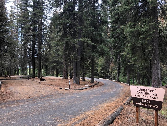
Sagehen Creek Campground is located on the shores of the scenic Sagehen Reservoir at an elevation of 4997 feet. Visitors enjoy boating, fishing, exploring Joe’s Creek Trail, as well as utilizing the non-motorized Sagehen Reservoir Trail.

Recreation

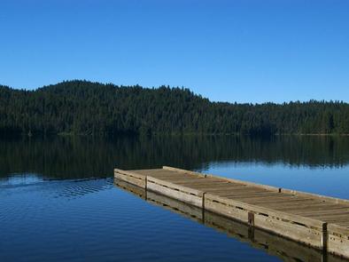
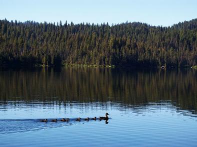
Sagehen Reservoir offers great boating, canoeing, and rainbow trout fishing. A boat ramp and dock are located within the campground.There is a 15 mph speed limit on the reservoir. Hiking, biking, horse, and ATV trails are abundant in the area, including Joe’s Creek Trail, which begins not far from the campground. The Sagehen Reservoir Trail, a 4-mile loop around the lake, offers great fishing spots, beautiful viewpoints and wildlife watching opportunities for hikers, mountain bikers and horseback riders. The Sagehen and KYAOTT ATV Trail Systems can be accessed near the reservoir, offering more than 35 miles of trails for ATVs and motorcycles, but hikers, mountain bikers and horseback riders can enjoy these trails as well.

Facilities

The campground contains several single-family sites, a few of which are accessible, all with picnic tables and campfire rings. Vault toilets and hand-pumped drinking water are provided. Firewood is available for purchase from the host.

Natural Features

The campground is situated in a forest of towering Ponderosa pine, Engelmann spruce, Douglas fir, and grand fir, which provide plentiful shade in most sites. Some sites afford lake views. Summer temperatures range from 80 to 90-degree days to cooler nights. A variety of berries and mushrooms can be found throughout the area. Local wildlife includes deer, elk, black bear, goshawk, woodpeckers, and boreal owls.

Reservation

More from CampingHiking.net:

WILLIAM KENT CAMPGROUND, California Campground Images, Info & Reservations

Listen Directions William Kent Campground is 2 miles south of Tahoe City on California Highway 89. Phone 530-583-3642 Activities BIKING, BOATING, CAMPING, INTERPRETIVE PROGRAMS, FISHING, VISITOR CENTER, WATER SPORTS, SWIMMING SITE Keywords WILK,TAHOE CITY,WEST SHORE,LAKE TAHOE,LAKE TAHOE BASIN – FS Related Link(s) Rec Area Info & Images California State Tourism

BLUE BAY, Oregon Campground Images, Info & Reservations

Listen Directions From Sisters, travel approximately 13 miles northwest on Highway 20/126. Turn left onto Forest Road 2070 (Suttle Lake Campgrounds). Travel just less than 1/2-mile to Blue Bay entrance on the right. Phone 541-323-1746 Activities BOATING, CAMPING, INTERPRETIVE PROGRAMS, FISHING, HIKING Keywords BLBA,SUTTLE LAKE CAMPGROUND,DESCHUTES NF – FS Related

PURGATOIRE CAMPGROUND, Colorado Campground Images, Info & Reservations

Listen Directions From La Veta, Colorado, take State Route 12 south for 25.3 miles to Purgatoire campground sign. Turn right onto gravel Route 34. Go 0.2 miles to "T" intersection. Turn right and drive 4 miles on rough gravel road to campground. Phone FOR RESERVATIONS CALL (877) 444-6777, FOR OTHER

REUNION FLAT, Wyoming Campground Images, Info & Reservations

Listen Directions From Driggs, Idaho, travel 9 miles east. Turn east at the Key Bank on Little Avenue and follow the road to the forest boundary. Turn right on Forest Road 009 and go 3 miles to the campground. Phone 208-270-0150 OR 541-351-1182 Activities BIKING, CAMPING, FISHING, HIKING, WILDLIFE VIEWING

OLD KUTTAWA, Kentucky Campground Images, Info & Reservations

Listen Directions From Nashville, take I-24 West to Exit 40. Turn left on 62 and then right on Highway 295. Follow Highway 295 to recreation area entrance. Phone LAKE BARKLEY RESOURCE MANAGERS OFFICE: 270-362-4236 Activities BOATING, FISHING, DAY USE AREA, SWIMMING SITE Keywords OLDK,LAKE BARKLEY,KUTTAWA,OLD KUTTAWA,BARKLEY LOCK & DAM Related