
Directions
From Phoenix, Arizona: When traveling Northbound on I-17 take the Bumble Bee Exit 248 and continue North on the dirt road, taking Forest Road (FR) 259 to Crown King. From Crown King, take (FR) 259A south for 0.5 mile to the junction of 52. Take FR 52 southeast for about 6 miles to the Horse Thief Basin Recreation Area. Turney Gulch is approximately one mile past Horse Thief Lake.
Alternate route from Flagstaff, Arizona: Traveling Southbound on I-17 take Exit 263, turn right and proceed towards a roundabout and merge onto Hwy 69 North towards Prescott for 2.4 miles until turning left on to Spring Ln. in Spring Valley. Continue down Spring Ln. for 0.7 Miles until you get to Duffers Dr. turn right onto Duffers Dr. The road will become unpaved, continue to travel for 1.4 miles until you get to the intersection of Duffers Dr. and S. Antelope Creek Rd. and turn left and drive for 23 miles until arriving to Crown King, Arizona. From Crown King, take (Forest Rd) 259A south for 0.5 mile to a junction with 52. Take FR 52 southeast for about 6 miles to the Horse Thief Basin Recreation Area. Turney Gulch is about one mile past Horse Thief Lake.
From Prescott, Arizona: From Downtown Prescott travel South on State Route 69 for 31 miles until you arive to Spring Valley, Arizona and turn right onto Spring Ln. Continue down Spring Ln. for 0.7 Miles until you get to Duffers Dr. turn right onto Duffers Dr. The road will become unpaved at this point, continue to travel for 1.4 miles until you get to the intersection of Duffers Dr. and S. Antelope Creek Rd. and turn left and drive for 23 miles until arriving to Crown King, Arizona From Crown King, take 259A south for 0.5 mile to a junction with 52. Take FR 52 southeast for about 6 miles to the Horse Thief Basin Recreation Area. Turney Gulch is about one mile past Horse Thief Lake.
The facility is located on an unimproved dirt road; high clearance vehicles are highly recommended only.
Phone
1 (877) 444-6777
Activities
BOATING, CAMPING, FISHING, HIKING, HUNTING
Keywords
TURN,PRESCOTT NF – FS
Related Link(s)
Overview
Turney Gulch is a remote, scenic location for groups of up to 100 people to rest under the stars and towering pines of Prescott National Forest. Site accomodates 30 vehicles or less. The site lies near Horse Thief Lake and is seven miles southeast of the small town of Crown King, Arizona, a former ghost town. Campers can enjoy hunting, fishing, hiking, wildlife viewing and visiting historic sites in the area. To make reservations click on the availability button to the right to book this site or call 1 (877) 444-6777. For general campground questions contact the Bradshaw Ranger District at 1 (928) 443-8000.
Recreation
Campers have no shortage of activities both in and around the campground. The shade of the ponderosas invites guests to picnic and relax at the facility, while the nearby Horsethief Lake allows fishing and boating (electric motors and oars only). Anglers cast for largemouth bass, channel catfish and sunfish. Hunting is available in the surrounding forest, and the nearby Castle Creek Wilderness provides numerous trails for hikers to explore.
Facilities
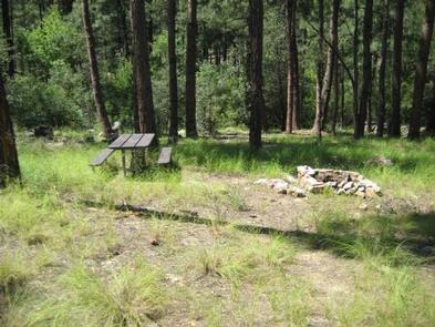
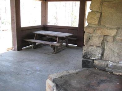
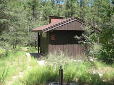
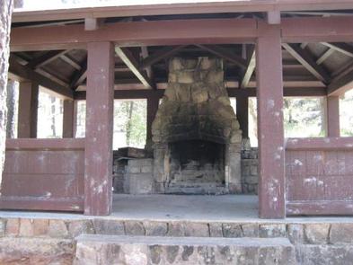
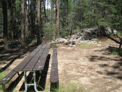
Turney Gulch is the only group campground near Horse Thief Lake and is close to one family campground. The facility has a rustic mountain feel with a picnic shelter, 15 picnic tables, fire grills and an accessible vault toilet. Drinking water and trash collection are provided for your convenience. The site lies on an unimproved dirt road and the drive can be challenging; campers should use high clearance 4 x4 vehicles to get there.
Natural Features
The facility is situated in a ponderosa pine forest at an elevation of 6,000 feet in the Bradshaw Mountains of north-central Arizona. The forest is home to a wide variety of wildlife, including deer, mountain lions, bobcats, coyotes, fox, rabbits, lizards, snakes, bald eagles and other species of birds.
Summer temperatures offer a pleasant relief from the heat of nearby deserts, and winter is cool to cold with occasional snow. Afternoon thunderstorms are possible from late June through mid-September.
Nearby Attractions
The small town of Crown King has a general store with basic supplies.