Directions
Coming from the North (I-25): At the DoÑa Ana Exit: From NM320 (Thorpe Road) in DoÑa Ana, go west to US 85, then go north about a half a mile to Shalem Colony Road. Turn west on Shalem Colony Trail, which curves to the south. Go about 1.5 miles until you cross over the Rio Grande, and take a right onto county road, Rocky Acres Trail. After turning on Rocky Acres Trail, go approximately 1/4 mile, and then turn left onto the only dirt road (Permian Track Road) leading to the west. Cross over a cattleguard, and continue to the west. This road, past about a mile, is for high-clearance, 4wd vehicles only.
Coming from the South (Las Cruces): Travel on Picacho Ave./Hwy. 70, at the stop light with Shalem Colony Trail. Go north on Shalem Colony Trail for approximately 5.5 miles. Prior to reaching the Rio Grande, you will reach a county road, Rocky Acres Trail. Turn west on Rocky Acres Trail. Go west approximately 1/4 mile to a dirt road entrance on the left-hand side. Cross over a cattleguard and continue to the west. This road, past about a mile, is for high-clearance, 4wd vehicles only.
Phone
575-525-4300
Activities
HIKING, HORSEBACK RIDING, OFF HIGHWAY VEHICLE, WILDLIFE VIEWING
Camping Reservations
Reserve your campsite at these camping areas:
Hiking Trails
Looking for nice hiking areas to take a hike? Choose from these scenic hiking trails:
Related Link(s)
More New Mexico Recreation Areas
BLM New Mexico YouTube Channel
BLM New Mexico YouTube Channel
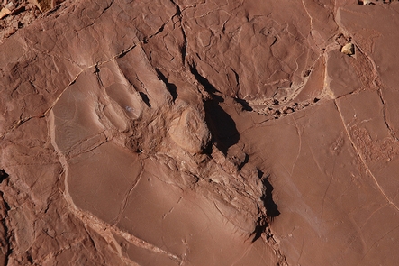
The Prehistoric Trackways National Monument was established in 2009 to conserve, protect, and enhance the unique and nationally-important paleontological, scientific, educational, scenic, and recreational resources and values of the Robledo Mountains in southern New Mexico. The Monument includes a major deposit of Paleozoic Era fossilized footprint megatrackways within approximately 5,280 acres.
The trackways contain footprints of numerous amphibians, reptiles, and insects (including previously unknown species), plants, and petrified wood dating back 280 million years, which collectively provide new opportunities to understand animal behaviors and environments from a time predating dinosaurs. The site contains one of the most scientifically-significant Early Permian track sites in the world.
There are opportunities for hiking, horseback riding, and off highway vehicle driving in portions of the monument. However, viewing Trackway fossils is limited. At this time, there are no developed sites interpreting the fossils. To preserve them for ongoing and future scientific study, some trackway fossils have been removed and transported to the New Mexico Museum of Natural History and Science, making up the Jerry MacDonald Paleozoic Trackways Collection. Anyone interested in viewing these fascinating tracks can do so by visiting the Museum, which offers public tours of their Geoscience Collection, including the Trackways Collection, by reservation. The Las Cruces Museum of Nature and Science also has a 30 foot and a 15 foot trackway on display.

