COVE CREEK UPPER GROUP CAMP, NC Campground Reservation, Info, Images, Map, Directions

COVE CREEK UPPER GROUP CAMP, North Carolina Campground Images, Info & Reservations

Directions

From the Asheville airport, take Highway 280 west to the U.S. Highway 64/280/276 intersection at Pisgah National Forest. Turn north onto U.S. Highway 276. Go 4.5 miles to Forest Road 475A and turn left. Travel on 475A for 3 miles to the campground on the right.

Phone

(828) 552-8040

Activities

BIKING, CAMPING, INTERPRETIVE PROGRAMS, FISHING, HIKING

Keywords

COVU,UPPER COVE CREEK,PISGAH FOREST,NFs IN NORTH CAROLINA – FS

Related Link(s)

Rec Area Info & Images

North Carolina State Road Conditions

North Carolina State Tourism

Overview

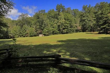
Cove Creek Upper Group Camp is one of two group campsites nestled along Cove Creek in the lush forests of the Appalachian Mountains. The facility can accommodate large groups of up to 60 people and offers year-round opportunities for hiking, mountain biking, fishing and picnicking in one of the most scenic areas in the state.

Recreation

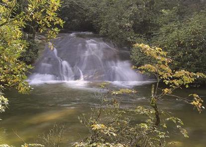
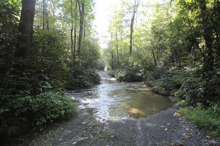
Campers can easily relax with a book or deck of cards in the shaded camping area, or seek out activities close by. The area is a hub for numerous hiking, backpacking and mountain biking trails, some of which can be accessed from the campground. Hikers can follow a trail along the creek that leads to a scenic waterfall. Great trout fishing is also available in the creek and river.

For visitors wishing to learn more about the area, interpretive programs may be available upon request.

Facilities

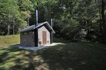
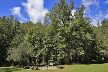
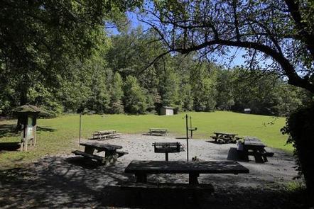
The Upper Group Camp site can accommodate up to 60 people at a time. The facility is shaded with plenty of room for tents and RVs. It is equipped with picnic tables, vault toilets, grills, campfire rings and drinking water.

Natural Features

The campground lies in Pisgah National Forest. The surrounding land boasts mile-high peaks, cascading waterfalls and slopes thickly forested with hardwoods. The group camping area is adjacent to both Cove Creek and the beautiful Davidson River. Visitors should note that two creek crossings are required on the road leading to the upper group camp. Heavy rains may temporarily make crossing impossible; a four-wheel drive or high clearance vehicle is highly recommended and all crossings are attempted at users own risk.

Nearby Attractions

The city of Asheville, North Carolina, is about an hour away and offers numerous cultural attractions, art galleries, shops and restaurants.

Reservation

More from CampingHiking.net:

GROOM CREEK SCHOOLHOUSE, Arizona Campground Images, Info & Reservations

Directions From Phoenix, Arizona, take I-17 north for 61.8 miles. Take exit 262 toward Cordes Junction/Prescott. Merge onto State Route 69 west and follow for 33.8 miles. At the split, take the ramp for Route 89 south. Turn slight left onto East Gurley Street/89 and follow for about 0.8-mile. Turn

LOWER BRIDGE CAMPGROUND, Oregon Campground Images, Info & Reservations

Directions From Sisters, OR: Travel 9.6 miles northwest on Highway 20, then 13.6 miles north on Forest Road 14. Phone 541-323-1746 Activities CAMPING Keywords Related Link(s) Rec Area Info & Images Oregon State Tourism Oregon State Road Conditions Overview Lower Bridge Campground earned its name for being located on the

KINNIKINNICK, California Campground Images, Info & Reservations

Directions Take Highway 168 east from Clovis to Shaver Lake. Continue through Shaver Lake to Huntington Lake. Continue around Huntington Lake for 1.3 miles to Kinnikinnick Campground (located adjacent to Catavee Campground). Phone 559-893-2111 Activities BOATING, CAMPING, INTERPRETIVE PROGRAMS, FISHING, HIKING, WATER SPORTS, SWIMMING SITE Keywords KINN,HUNTINGTON LAKE,SIERRA NF –

Agua Piedra Campground, New Mexico Campground Images, Info & Reservations

Directions From Las Vegas, New Mexico, take State Highway 518 approximately 51 miles to the Agua Piera Campground. From Penasco, New Mexico, travel east on State Route 75 about 5 miles, to an intersection. Turn right, onto State Route 518 (unmarked) and continue about 7 miles to campground entrance. From

GRAND ISLAND CABINS, Michigan Campground Images, Info & Reservations

Directions Beginning in fall and throughout winter, ferry service to the island is closed. Access to the island is only by personal watercraft, or, if the lake is frozen, access via foot or snowmobile. Please call ahead to find out if there is ice or open water. Crossing Lake Superior

LIZ CREEK CABIN, Idaho Campground Images, Info & Reservations

Directions There are no services located on the district, so travelers should have plenty of gas, food and water for their visit, including planning for possible emergency situations. The travel route to the cabin can be quite challenging even treacherous at times, as the gravel roads on the district can