CATHEDRAL ROCK PICNIC AREA, NV Campground Reservation, Info, Images, Map, Directions

CATHEDRAL ROCK PICNIC AREA, Nevada Campground Images, Info & Reservations

Listen

Directions

From Las Vegas, Nevada, take Highway 95 north to junction with Highway 157/Kyle Canyon. Turn left and travel approximately 21 miles to the picnic area at the end of the highway.

Phone

702-872-5486

Activities

CAMPING, HIKING, DAY USE AREA

Keywords

CATH,MOUNT CHARLESTON,LAS VEGAS,SPRING MTNS NAT. REC. AREA,HUMBOLDT-TOIYABE NF-FS

Related Link(s)

Rec Area Info & Images

Nevada State Road Conditions

Nevada State Tourism

Overview

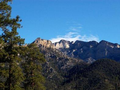
Cathedral Rock Group Picnic Area is located at the top of beautiful Kyle Canyon in the Spring Mountains National Recreation Area, just 30 miles from Las Vegas. Visitors enjoy hiking, horseback riding and scenic driving in this forested desert oasis.

Recreation

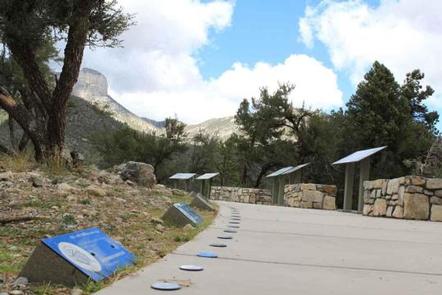
No trails can be accessed through the Picnic Area at the present time. Trails may be found at the Forest Service Trailhead on the other end of Cathedral Rock Picnic Area. The new Spring Mountain Visitor Center is a 15 minute drive down the canyon, with guided hikes and educational programs.

Facilities

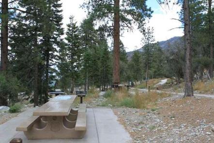
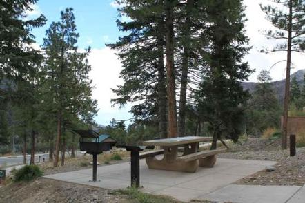
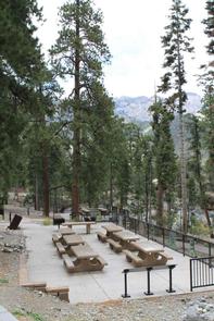
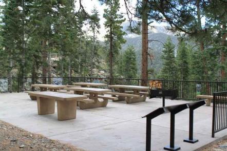
The picnic area is for day-use only. Two group sites are available, both with large picnic tables, serving tables, grills and cement site pads. Parking areas are paved. Vault toilets, drinking water, trash collection are provided.

Natural Features

The Spring Mountains National Recreation Area is a beautiful island in the desert, brimming with breathtaking scenery and diverse flora and fauna. The Bristlecone pine, the world’s oldest organism, and the rare Mount Charleston blue butterfly are both found within the Spring Mountains.

Over 100 springs create the namesake for the mountain range, creating the perfect place to escape the heat of the city.

The picnic area is set among a forest of ponderosa pine, white fir, aspen, mountain mahogany and Gambel oak, which provides partial shade. The area affords views of the surrounding Spring Mountains.

Nearby Attractions

More than 60 miles of hiking and horseback riding trails crisscross the area; two trails allow mountain biking. Rock climbing, picnicking and scenic driving are popular activities.

Reservation

More from CampingHiking.net:

GREEN RIVER CAMPGROUND, Utah Campground Images, Info & Reservations

Listen Directions Green River Campground is located approximately 12 miles north of US Highway 40. Take Utah State Route 149 from Jensen, Utah. Phone 435-781-7700 Activities BIKING, CAMPING, INTERPRETIVE PROGRAMS, FISHING, HIKING, WILDLIFE VIEWING, EVENING PROGRAMS Keywords GREEN RIVER CAMPGROUND,GREEN RIVER,DNM Related Link(s) Rec Area Info & Images Utah State

BIG SCRUB CAMPGROUND, Florida Campground Images, Info & Reservations

Listen Directions From I-75 east, travel on State Route 40 to Forest Road 588. Turn south on 588 and go approximately 8 miles. The campground is on the west side of the road. Phone 352-625-2520 Activities CAMPING, PICNICKING, WILDLIFE VIEWING Keywords BSCG,SCRUB,NFs IN FLORIDA – FS Related Link(s) Rec Area

ROCKY POINT (FT GIBSON), Oklahoma Campground Images, Info & Reservations

Listen Directions From Wagoner, Oklahoma: travel 4.5 miles north on Highway 69. Turn right at stoplight on East 690 Road. Travel 3 miles east. Turn left on South 320 Road and travel north for 3/4 mile to park entrance. Phone 918-462-2042 OR 918-682-4314 Activities BOATING, CAMPING, FISHING, HUNTING, SWIMMING SITE

LANE SPRING RECREATION AREA, Missouri Campground Images, Info & Reservations

Listen Directions From Rolla, Missouri, travel 12 miles south on U.S. Highway 63, then continue 1 mile west on Entrance Road. Phone 417-967-4194 Activities CAMPING, FISHING, HIKING, WATER SPORTS, WILDLIFE VIEWING Keywords LANE,LANE SPRING,LANE SPRINGS,LANE SPRINGS RECREATION AREA,MARK TWAIN NF -FS Related Link(s) Rec Area Info & Images Missouri State

WOLF CREEK GROUP SITE, Oregon Campground Images, Info & Reservations

Listen Directions From Roseburg, OR, travel east on NE Diamond Lake Blvd./OR-138 East for approximately 16 miles. Turn right onto Little River Road 17. Continue on Little River Road for 12 miles to Wolf Creek Campground, located on the right side of the road. The group site is within the

EDNA CREEK CAMPGROUND, Idaho Campground Images, Info & Reservations

Listen Directions Hayfork Group Cg (ID) HIGHWAY 21 Idaho City ID 83706 Phone 208-392-6681 Activities CAMPING, FISHING, VISITOR CENTER, WILDLIFE VIEWING Keywords None Related Link(s) Rec Area Info & Images Idaho State Tourism Idaho State Road Conditions Overview Edna Campground is located 56 miles northeast of Boise, Idaho, in a