WILD MARE HORSE CAMP, OR Campground Reservation, Info, Images, Map, Directions

WILD MARE HORSE CAMP, Oregon Campground Images, Info & Reservations

Listen

Directions

From Reedsport, Oregon, take Highway 101 south for 22 miles, turn right on Transpacific Lane. Proceed 1 mile, Cross the railroad tracks and turn right on Horsfall Road. Proceed 1.9 miles down Horsfall Road to Wild Mare Campground. Campground is located on south side of road. From North Bend, OR proceed north on Hwy, 101 for 1.5 miles to Transpacific Lane. Turn left and proceed 1 mile, Cross the railroad tracks and turn right on Horsfall Road. Proceed 1.9 miles down Horsfall Road to Wild Mare Campground. Campground is located on south side of road.

Phone

541-271-6000

Activities

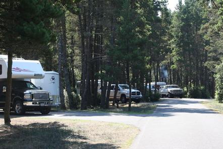
CAMPING, HORSEBACK RIDING

Keywords

WILM,SIUSLAW NF – FS

Related Link(s)

Rec Area Info & Images

Oregon State Tourism

Oregon State Road Conditions

Overview

Wild Mare Horse Campground is located along the central Oregon coast, 22 miles south of the town of Reedsport, and 2 miles north of Coos Bay.

Horse campers come here to explore the Wild Mare Horse Trail and take in captivating views of Oregon’s Pacific Coast, just a half mile from the campground.

Recreation

Equestrian campers are fond of the Wild Mare Horse Trail #4500. This trail begins under a canopy of alder and spruce, and then emerges into an open dune area that crosses down to the beach.

Some parts of the dunes are designated for hiking and horseback riding only, while off-road vehicle enthusiasts can roam free on the dunes north of the campground.

Facilities

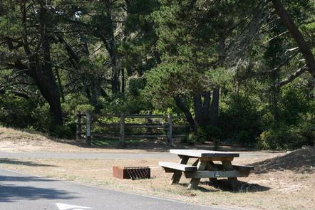
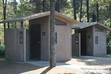
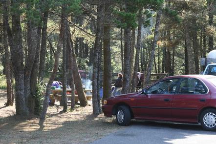
The year-round campground is equipped with drinking water, vault toilets, a picnic area, picnic tables, campfire rings, trash bins and recycling receptacles. Horses are welcome in the 12 corrals provided. Head to Horsfall Campground for the use of token operated showers.

Natural Features

Tucked among shore pine, Douglas fir and huckleberry, Wild Mare is part of the Oregon Dunes National Recreation Area, known for its wind-sculpted sand dunes towering up to 500 feet above sea level. This region is in the southern tip of Siuslaw National Forest, hugging the Pacific Ocean.

Nearby Attractions

Scenic water attractions are in every direction of the campground. Head south to Coos Bay, west to the Pacific, and east to Horsfall Lake.

Reservation

More from CampingHiking.net:

ASPEN (AZ), Arizona Campground Images, Info & Reservations

Listen Directions From Payson, take Highway 260 northeast toward Heber. Take a left at the sign for Woods Canyon Lake (Rim Road/Forest Road 300). Follow for about 5 miles and turn right onto the paved road at the sign toward Woods Canyon Lake (there is no road sign). Aspen Campground

POINT CAMPGROUND, Idaho Campground Images, Info & Reservations

Listen Directions Take State Highway 75 south from Stanley, Idaho, for 6 miles. Go west on Forest Road 214 for approximately 1.7 miles. Turn right onto Forest Route 213, drive a short distance and turn at Point Campground entrance. Phone 928-537-8888 Activities BIKING, BOATING, CAMPING, FISHING, HIKING, HORSEBACK RIDING, WATER

Diamond Creek Guard Station, Idaho Campground Images, Info & Reservations

Listen Directions From Soda Springs, take Highway 34 north approximately 12 miles to the China Hat turnoff (Blackfoot River Narrows). This road will follow Blackfoot River for another 11 miles to a junction; there is a Forest Service sign at this point. Take the right fork (Caribou National Forest Road

WEST LAKE, Colorado Campground Images, Info & Reservations

Listen Directions From Fort Collins, take Highway 287 north approximately 24 miles to Livermore. Turn west on County Road 74 and continue 24 miles to the campground. Phone 970-295-6700 Activities BIKING, BOATING, CAMPING, FISHING, HIKING, WILDLIFE VIEWING, CANOEING Keywords WLCO,REDFEATHER LAKES,ARAPAHO AND ROOSEVELT NF – FS Related Link(s) Rec Area

WALL CREEK CABIN, Montana Campground Images, Info & Reservations

Listen Directions From Ennis, take US Highway south for about 18 miles to Indian Creek and the McAtee Bridge fishing access site. Turn right and go nearly 1 mile to junction just beyond bridge. Turn left and travel toward Wall Creek Wildlife Management Area for 2.7 miles to T junction.