TEAL LAKE GROUP CAMPSITE, CO Campground Reservation, Info, Images, Map, Directions

TEAL LAKE GROUP CAMPSITE, Colorado Campground Images, Info & Reservations

Directions

From Walden: Take Highway 14 west for approximately 11 miles to Hebron. Turn right on County Road 24 driving west. After approximately 10 miles the road becomes Forest Road 60 and passes the Grizzly Creek Guard Station. Turn right on Forest Road 615. Drive approximately 3 miles and turn right into the Teal Lake Campground.

Phone

970-723-2700

Activities

CAMPING, FISHING, PICNICKING, WILDLIFE VIEWING

Keywords

TEAL,MEDICINE BOW-ROUTT NF-FS

Related Link(s)

Rec Area Info & Images

Colorado State Road Conditions

Colorado State Tourism

Overview

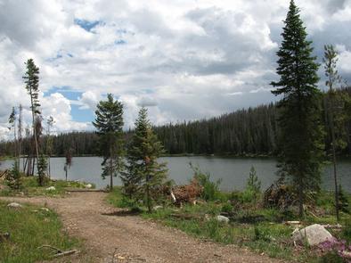
Teal Lake Group Campground is set along a small yet scenic lake in north central Colorado in the heart of the Rocky Mountains. Located in the Routt National Forest at an elevation of 9,000-ft., the lake is popular for trout fishing and lies close to a wilderness area with a variety of hiking and off-highway vehicle trails.

Recreation

Trout fishing and boating are popular activities in the clear, calm waters of Teal Lake. Only electric boats and non-motorized boats are permitted. Off-road vehicle enthusiasts have easy access to the Grizzly-Helena Trail nearby.

Hiking is great in the nearby Mount Zirkel wilderness, though hikers must drive to the trailheads.

Facilities

Teal Lake provides 17 individual campsites and one group site for up to 30 people. Campsites are private and have ample space. The group site has four picnic tables and two campfire rings for groups to gather.

Natural Features

Teal Lake is a 50-acre lake surrounded by a rocky shoreline and pine-fir forest. Some previously forested areas of the campground have been thinned due to pests and thus have more sun than others.

Black bear, bobcat, coyote, elk, mule deer and moose are just some of the many animals that inhabit the Medicine Bow-Routt National Forests and Thunder Basin National Grassland.

The area is generally snow-free from Memorial Day to Labor Day, but visitors should come prepared for anything, including freezing temperatures and snow during summer.

Nearby Attractions

The closest town is Walden, Colorado. Many more outdoor opportunities exist in the nearly 3 million acres of surrounding national forests and grasslands, including hiking, biking, camping, horseback riding, OHV riding, fishing, hunting, sightseeing and winter sports.

Reservation

More from CampingHiking.net:

BUMPUS MILLS, Tennessee Campground Images, Info & Reservations

Directions From Nashville, Tenn: Take I-24 west to Clarksville, TN. Follow Highway 79 South for 20 mi. to Highway 120. Follow Highway 120 for 10 mi. to Bumpus Mills, turn left onto Tobaccoport Road (Hwy. 1830) for 2.8 mi., turn left onto Oak Hill Road for . 9 mi., turn

HUMBUG CAMPGROUND, Oregon Campground Images, Info & Reservations

Directions 4.6 miles northeast of Detroit, Oregon. From Highway 22 at Detroit, turn east onto Breitenbush Road/Forest Service Road 46 and continue for 4.6 miles to Humbug Campground on the right. Phone 503-854-3366 Activities FISHING, WATER ACTIVITIES Keywords Related Link(s) Rec Area Info & Images Oregon State Road Conditions Forest

ROBERT W CRAIG, West Virginia Campground Images, Info & Reservations

Directions From Cumberland, MD: Take US 220 south to US 50W, go west to WV 42N, go north to WV 46E. Follow the signs to the Robert W. Craig Campground. Phone 304-355-2346 Activities BOATING, CAMPING, FISHING, HIKING, WATER SPORTS, DAY USE AREA, OTHER RECREATION CONCESSION SITE Keywords ROBE,JENNING RANDOLPH LAKE,JENNINGS

ASPEN GLADE, Colorado Campground Images, Info & Reservations

Directions From Antonito, Colorado, go west on Highway 17 for approximately 15 miles to the Aspen Glade Campground. Phone 435-245-6521 Activities CAMPING, FISHING Keywords ASGL,RIO GRANDE NF- FS Related Link(s) Rec Area Info & Images Colorado State Road Conditions Colorado State Tourism Overview Aspen Glade Campground sits on the Conejos

MINERSVILLE CAMPGROUND, California Campground Images, Info & Reservations

Directions From Weaverville: take Highway 3 north for 15 miles. Turn right on Minersville/Bushtail Road for 1 mile. Phone 530-623-2121 Activities BOATING, CAMPING, FISHING, HIKING, WATER SPORTS, SWIMMING SITE Keywords Trinity Lake,Clair Engle Lake,Minersville Related Link(s) Rec Area Info & Images California State Road Conditions California State Tourism Forest Service

NAVAJO LAKE CAMPGROUND, Utah Campground Images, Info & Reservations

Directions Go east from Cedar City on Scenic Byway SR 14, 25 miles to the Navajo Lake road turnoff to the south. Follow the Navajo Lake road 5 miles to Navajo Lake campground. Phone 801-226-3564 Activities BIKING, BOATING, CAMPING, FISHING, WILDLIFE VIEWING, SWIMMING SITE, PHOTOGRAPHY, KAYAKING, CANOEING, WATER ACCESS Keywords