CANAL, KY Campground Reservation, Info, Images, Map, Directions

CANAL, Kentucky Campground Images, Info & Reservations

Directions

From Interstate I-24, take Grand Rivers Exit 31. Drive south on Highway 453 for approximately 4 miles. Turn left onto J.H. O’Bryan Avenue for .1 miles. Turn right onto Canal Campground Road for .5 miles.

Phone

270-362-4840

Activities

CAMPING, FISHING, DAY USE AREA, SWIMMING SITE

Keywords

CANA,LAKE BARKLEY,BARKLEY LOCK & DAM

Related Link(s)

Rec Area Info & Images

Kentucky State Road Conditions

Kentucky State Tourism

Overview

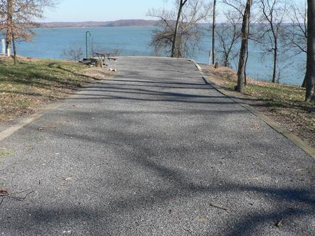
Situated along a peninsula between the lush shorelines of Lake Barkley and Kentucky Lake, Canal Campground offers modern camping and provides the ideal setting to enjoy nature at its best with family and friends.

Visitors can enjoy a stunning view of the Barkley Dam and boats traveling through the canal from the comfort of their campsite. The campground faces Barkley Lake, and the shore of Kentucky Lake is a brisk one-mile walk across the canal.

Recreation

From water sports to wildlife viewing to hiking and biking, Canal Campground is the perfect setting for outdoor activities. Eagle nests can be spotted throughout the grounds, and its not unlikely for visitors to encounter deer and other wildlife. A short hiking trail allows campers to enjoy the outdoor scenery at their leisure.

Fishing is also a popular pastime, and during warm months bass and catfish are plentiful in both lakes.

Facilities

A designated swimming beach and a boat ramp help campers enjoy the lake. Picnic pavilions and a playground create a perfect setting for a party or family get-together. For group camping, several sites surrounding the pavilion can be reserved, and a fishing float nearby allows groups to go out on the lake together.

Electric hook-ups, showers and flush restrooms create a comfortable camping experience.

Natural Features

Lake Barkley, as part of a dam project at the Cumberland River, spans 134 miles along the Kentucky landscape, offering countless recreational activities to visitors. The canal connects Lake Barley with Kentucky Lake, forming one of the greatest freshwater recreational complexes in the country.

Nearby Attractions

Grand Rivers, a short drive from the campground, has several restaurants and two public marinas.

Reservation

More from CampingHiking.net:

Horsethief Group Sites, Utah Campground Images, Info & Reservations

Directions From Moab, drive 9 miles north on Highway 191, turn west on Highway 313. Drive 12 miles and then turn right and drive in the short entrance road to the campground. Phone 435-259-2100 Activities AUTO TOURING, BIKING, CAMPING, HIKING, PHOTOGRAPHY, MOUNTAIN BIKING, STAR GAZING, SCENIC DRIVE Keywords Related Link(s)

Fort Dupont Park Picnic Areas, District of Columbia Campground Images, Info & Reservations

Directions Please visit the website for detailed directions, . Phone 202-690-5152 Activities BIKING, HISTORIC & CULTURAL SITE, INTERPRETIVE PROGRAMS, HIKING, PICNICKING, WILDLIFE VIEWING, DAY USE AREA, GUIDED INTERPRETIVE WALKS Keywords Fort Dupont Park Picnic Areas,Fort Dupont Related Link(s) Rec Area Info & Images District of Columbia State Road Conditions District

BUTTE LAKE GROUP, California Campground Images, Info & Reservations

Directions From Redding, drive 63 miles east on state highway 44 to Old Station. From intersection of state highway 89 and 44, continue east on state highway 44 for 11 miles. Watch for sign to Butte Lake Campground. Turn right and continue for 6 miles on a rough gravel road.

PRAIRIE CREEK (AR), Arkansas Campground Images, Info & Reservations

Directions From Rogers, Arkansas, take Highway 12/Prairie Creek Drive east for just over 3 miles. Turn left onto North Park Road and follow to the campground. Phone 479-925-3957 Activities BOATING, CAMPING, FISHING, HIKING, WATER SPORTS, SWIMMING SITE Keywords PRA2,BEAVER LAKE,BEAVER LAKE Related Link(s) Rec Area Info & Images Arkansas State

TWELVE MILE FLAT, Utah Campground Images, Info & Reservations

Directions Travel east up Twelve Mile Canyon on Forest Development Road 22 for approximately 20 miles, or travel west up Ferron Canyon on Forest Development Road 22 for 31 miles. Phone 435-384-2372 Activities BIKING, CAMPING, HIKING, HUNTING, WILDLIFE VIEWING Keywords TWEM,MANTI-LASAL NF -FS Related Link(s) Rec Area Info & Images

UPPER BILLY CREEK CG, California Campground Images, Info & Reservations

Directions Take Highway 168 east from Clovis to Shaver Lake. Continue through Shaver Lake to Huntington Lake. Continue around Huntington Lake for 3.2 miles to Upper Billy Creek Campground. Phone 559-893-2111 Activities BOATING, HISTORIC & CULTURAL SITE, CAMPING, INTERPRETIVE PROGRAMS, FISHING, HIKING, WATER SPORTS, SWIMMING SITE Keywords BICR,HUNTINGTON LAKE,SIERRA NF