FLATROCK (TEXAS), TX Campground Reservation, Info, Images, Map, Directions

FLATROCK (TEXAS), Texas Campground Images, Info & Reservations

Directions

From Coleman, TX, take Highway 153 west for 8 miles to the main entrance of Hords Creek Lake. Follow signs into the campground.

Phone

325-625-2322

Activities

BIKING, BOATING, CAMPING, FISHING, RECREATIONAL VEHICLES, SWIMMING SITE, PADDLING, MOTOR BOAT, PADDLE BOATING, WATER ACTIVITIES, KAYAKING, CANOEING, NON-MOTORIZED BOATING, WATER ACCESS, JET SKIING, WATER SKIING

Keywords

FLAR,HORDS CREEK LAKE,FLATROCK TEXAS,HORDS CREEK LAKE

Related Link(s)

Rec Area Info & Images

Texas State Road Conditions

Texas State Tourism

Overview

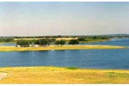
Flatrock campground is situated on Hords Creek Lake with nice shade from trees, a fishing dock and gravel swimming areas for beating the Texas heat.

Recreation

Visitors come to Flatrock for fishing, boating and simple relaxation. The popular catches on the lake include largemouth bass, sunfish and white crappie. When water levels are high enough, water skiing is also a fun sport here.

Facilities

More than 50 campsites have water and electric hookups – ten of which have sewer hookups. Seven group shelters are available for day use. The swim beach, open to all overnight campers, is in Flatrock Park in area #1.

Boat ramps, fishing piers and fish cleaning stations are additional amenities at the park.

Natural Features

Hords Creek Lake is in the center of Texas, north of the Texas Hill Country. Gently rolling hills covered with live oaks make Hords Creek Lake a beautiful getaway, despite the sometimes unbearable heat.

Nearby Attractions

Circle the lake to cruise through neighboring Friendship Park and Lakeside Park.

For a dose of city conveniences, head to Coleman, just eight miles east of the lake.

Charges & Cancellations

Standard Cancellation Rates Apply.

Reservation

More from CampingHiking.net:

SHEEP TRAIL CAMPGROUND, Idaho Campground Images, Info & Reservations

Directions From Stanley, Idaho, take State Highway 21 west for approximately 10 miles. Turn south between mileposts 121 and 122. Take Forest Road 613 to Sheep Trail Campground, located adjacent to State Highway 21. Phone 928-537-8888 Activities BIKING, CAMPING, FISHING, HIKING, WILDLIFE VIEWING Keywords SHEE,SAWTOOTH NF – FS,”Flaming Gorge National

DALE HOLLOW DAMSITE, Tennessee Campground Images, Info & Reservations

Directions From Celina, Tennessee, take Highway 53 North for 2 miles. Turn right on Dale Hollow Dam Road, then take the second right on Campground Road. Follow signs to Dale Hollow Dam Recreation Area. It is recommended that visitors do not rely soley on GPS or Mapquest to reach the

NORTH BEND PARK, Virginia Campground Images, Info & Reservations

Directions The physical address for North Bend Park: 1930 Mays Chapel Road, Boydton, VA 23917. It is located approximately 20 miles west of South Hill, VA. Phone 434-738-0059 Activities BIKING, CAMPING, FISHING, HIKING, HUNTING, WILDLIFE VIEWING, SWIMMING SITE, DISC GOLF Keywords NORB,BUGGS ISLAND,JOHN H KERR DAM Related Link(s) Rec Area

BLIND PASS CABIN, Alaska Campground Images, Info & Reservations

Directions The cabin is located approximately 40 air miles north of Ketchikan on the northwest shore of Hassler Island, across from Black Island. Accessible by float plane or by boat. Mooring buoy in front of cabin is first-come, first-serve. Refer to USGS topographic map, Ketchikan D-5, and check local tide