LINTON, KY Campground Reservation, Info, Images, Map, Directions

LINTON, Kentucky Campground Images, Info & Reservations

Listen

Directions

From Nashville take I-24 west to Cadiz, exit 65. Make a left onto Highway 68 for 8 miles to Highway 139. Make a left on Highway 139 and go 6 miles to Highway 164. Make a right on Highway 164 and the day use area is 8 miles from there.


Phone

LAKE BARKLEY RESOURCE MANAGERS OFFICE: 270-362-4236

Activities

CAMPING, VISITOR CENTER, SWIMMING SITE

Keywords

LINT,LAKE BARKLEY,BARKLEY LOCK & DAM

Related Link(s)

Rec Area Info & Images

Kentucky State Road Conditions

Kentucky State Tourism

Overview

Linton Recreation area is a day-use haven that sits on Lake Barkley near wooded rolling hills and abundant wildlife. Whether it’s a gathering of family or friends, visitors can enjoy the the excellent atmosphere beautiful scenery.

Recreation

Boating and fishing are a big hit, as is swimming in the designated sandy swimming area and playing sports like soccer or Frisbee in the grassy open fields.
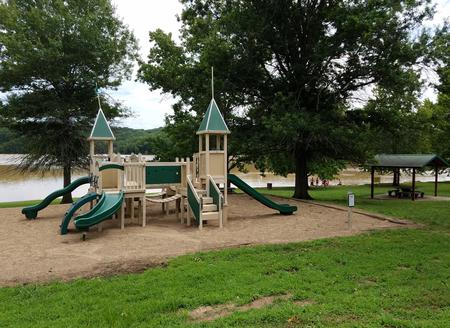
Facilities

The accessible picnic shelter fits 100 guests and 50 vehicles. Other perks include a flush toilet, playground, grills and swimming beach. No electric hookups are available.

Natural Features

The recreation area is on the shores of Lake Barkley, nestled in the wooded, rolling hills of southwestern Kentucky, very close to the border with Tennessee. Lake Barkley covers 57,900 acres with 1,004 miles of shoreline and offers warm water temperatures for comfortable recreation during summer months.

Nearby Attractions

Visit Fort Donelson National Battlefield, where the Union Army won its first battle in the Civil War.

Land Between the Lakes National Recreation Area is just across the lake and features more than 170,000 acres of public land with numerous historical and outdoor attractions.

Reservation

More from CampingHiking.net:

UPPER LITTLE TRUCKEE, California Campground Images, Info & Reservations

Listen Directions From either east bound or west bound Interstate 80 in Truckee take exit 188, Highway 89 north to Sierraville. In aproximately 12 miles turn left into the campground. Phone (530) 994-3401 Activities BIKING, CAMPING, FISHING, HIKING, HUNTING, WATER ACCESS, SCENIC DRIVE Keywords UPLI,TAHOE NF – FS Related Link(s)

WALLASHUCK, Iowa Campground Images, Info & Reservations

Listen Directions 890 190th Ave Pella, Iowa 50219 Take County Highway G-28 4 miles west of Pella, then go 0.8 miles south on 190th Avenue. Phone 641-828-7522 Activities BIKING, BOATING, CAMPING, FISHING, HIKING, VISITOR CENTER Keywords WALA,LAKE RED ROCK Related Link(s) Rec Area Info & Images Iowa State Road Conditions

KEOWEE PARK SHELTER, North Carolina Campground Images, Info & Reservations

Listen Directions From Charlotte, North Carolina, take I-77 North (approximately 60 miles) before merging onto Highway 421 North towards Wilkesboro/Boone. Continue to Exit 286B (approximately 20 miles), turn left onto Highway 268 and continue for approximately 7.5 miles. Turn the first right after the bridge. (You will see a sign

MOUNT PRINCETON, Colorado Campground Images, Info & Reservations

Listen Directions From Buena Vista, Colorado, take Highway 285 south to Nathrop. Turn west on County Road 162 and travel 7 miles to the campground. Phone CAMPGROUNDS DO NOT HAVE PHONE SERVICE, CALLING TO CHECK AVAILABILITY PRIOR TO ARRIVAL IS NOT POSSIBLE. FOR RESERVATIONS CALL: 1-877-444-6777 Activities HISTORIC & CULTURAL

PRAIRIE CREEK (AR), Arkansas Campground Images, Info & Reservations

Listen Directions From Rogers, Arkansas, take Highway 12/Prairie Creek Drive east for just over 3 miles. Turn left onto North Park Road and follow to the campground. Phone 479-925-3957 Activities BOATING, CAMPING, FISHING, HIKING, WATER SPORTS, SWIMMING SITE Keywords PRA2,BEAVER LAKE,BEAVER LAKE Related Link(s) Rec Area Info & Images Arkansas

HORSE CREEK PAVILION, Tennessee Campground Images, Info & Reservations

Listen Directions From Greeneville, take TN 107 north for six miles. Turn right at Horse Creek Road and follow the signs for about two miles to the recreation area. Phone (423)638-4109 Activities CAMPING, FISHING, HIKING, PICNICKING, WILDERNESS, FISH VIEWING SITE, DAY USE AREA, WATER ACTIVITIES, BIRDING, WATER ACCESS, BACKPACKING Keywords