RIVER ROAD PARK, MO Campground Reservation, Info, Images, Map, Directions

RIVER ROAD PARK, Missouri Campground Images, Info & Reservations

Directions

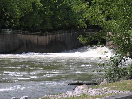
From Piedmont, MO, follow state highway HH for 6 miles. Campground will be located just below Clearwater Lake Dam. Follow signs into campground.

Phone

573-223-7777 (CLEARWATER LAKE PROJECT OFFICE) RIVER ROAD PARK GATE HOUSE(573-223-4424

Activities

BOATING, CAMPING, FISHING, HIKING, HUNTING, WATER SPORTS, SWIMMING SITE

Keywords

RILB,CLEARWATER LAKE,RIVER VIEW,BELOW THE DAM,RIVER ROAD L BANK,CLEARWATER LAKE

Related Link(s)

Rec Area Info & Images

Missouri State Road Conditions

Missouri State Tourism

Overview

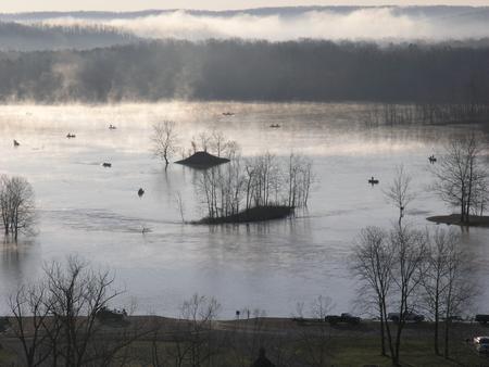
Set on the banks of a calming river, just below the entertaining Clearwater Lake lies River Road Park, known as a jolly ol’ place to camp.

The beautiful area is enhanced each spring by flowering shrubs and trees like the redbud, hawthorn, dogwood and wild plum. And bald eagles stay year-round and are known to nest near the lake.

Recreation

Look for wildlife and pretty landscapes on the Black River Hike and Bike Trail. The trail starts at River Road Park and connects with the Blue Heron and Bottomland interpretive trails. Wildlife includes wetland waterfowl, fox, deer and geese.

The lake and river below provide excellent fishing, swimming and canoeing.

Facilities

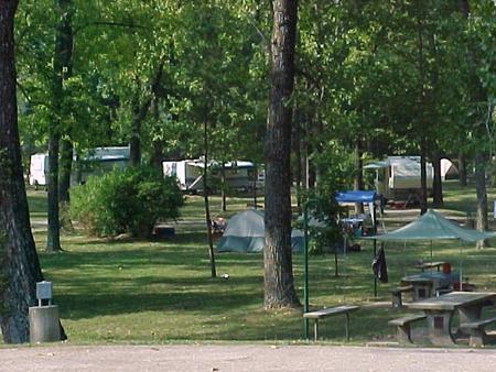
The majority of campsites have electric and water hookups. Additional amenities include a dump station, hot showers, picnic shelters, a boat ramp, and a playground.

Three group picnic shelters are available for reservation, and these also come with electricity.

Natural Features

River Road Park near Clearwater Lake lies below the dam on the Black River.

The lake’s shoreline is studded with picturesque bluffs covered in sweet william flowers, indented bays, and serene coves.

Nearby Attractions

In the area, campers enjoy visiting traditional drive-in movie theaters, the Sam A. Baker State Park, local golf courses, and the historic Civil War site at Fort Benton.

Reservation

More from CampingHiking.net:

FOWLERS CAMPGROUND, California Campground Images, Info & Reservations

Directions From McCloud, California, go east on Highway 89. Drive 5 miles and look for the Fowlers/Lower Falls Sign. Turn right just after the sign and drive approximately 1 mile. Once you cross the River Loop Road take the left fork into the campground. The right fork will take you

AVONDALE, Tennessee Campground Images, Info & Reservations

Directions From Nashville, TN, take I-65 N to TN-386/Vietnam Veterans Blvd. Take exit 9 from TN-386/Vietnam Veterans Blvd, turn right onto Shute Lane. Continue straight onto Avondale Access Road. Follow signs into recreation area. Phone (615) 822-4846 Activities BOATING, CAMPING, FISHING, KAYAKING, CANOEING, WATER ACCESS Keywords AVON,OLD HICKORY LAKE,OLD HICKORY

DALE MILLER YOUTH, Illinois Campground Images, Info & Reservations

Directions From I-57 take take exit 71 and turn west onto Route 14. After 3 miles turn right on Rend City Road, then right again on Main Dam Road. Continue 3 miles to the camp entrance on the left. Phone 618-724-2493 Activities BIKING, BOATING, CAMPING, INTERPRETIVE PROGRAMS, FISHING, HIKING, HUNTING,

HAWKER POINT, Missouri Campground Images, Info & Reservations

Directions From Stockton, Missouri, take State Highway 39 south for 6.2 miles, turn left on Highway H and continue for 5.2 miles to the park entrance. Phone 417-276-7266 Activities BOATING, CAMPING, FISHING, VISITOR CENTER, WILDLIFE VIEWING Keywords HAWK,STOCKTON LAKE,STOCKTON LAKE Related Link(s) Rec Area Info & Images Missouri State Tourism

Hellgate Campground, Montana Campground Images, Info & Reservations

Directions From Helena, MT: Head east along Co Rd 430/Canyon Ferry Rd from Helena, MT, continue for 38 miles to the Hellgate Campground and Group Use Shelter Area sign and turn right. Continue straight until you reach the campground. From Townsend, MT: Head north on Hwy 284 for 21 miles

FATHER DYER, Colorado Campground Images, Info & Reservations

Directions From Leadville, Colorado, drive west on County Road 4 about 3 miles, turn right on County Road 9C and follow to Father Dyer Campground on the left. Phone 719-486-0749 (INFORMATION ONLY, NO RESERVATIONS) Activities BOATING, HISTORIC & CULTURAL SITE, CAMPING, FISHING, HIKING Keywords FATH,TURQUOISE LAKE,LEADVILLE,PIKE AND SAN ISABEL NF-