SHOAL BAY, AR Campground Reservation, Info, Images, Map, Directions

SHOAL BAY, Arkansas Campground Images, Info & Reservations

Directions

From New Blaine, Arkansas, take State Route 197 north for 2 miles. Follow signs into campground.

Phone

479-938-7335

Activities

BOATING, CAMPING, FISHING, WILDLIFE VIEWING, SWIMMING SITE

Keywords

SHOA,DARDANELLE LAKE – ARK.RIV.NAV.,DARDANELLE LAKE

Related Link(s)

Rec Area Info & Images

Arkansas State Tourism

Arkansas State Road Conditions

Overview

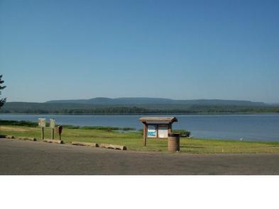
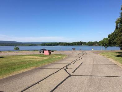
This shady campground sits on the scenic Shoal Bay arm of Lake Dardanelle, offering an excellent setting for boating, swimming and wildlife viewing.

Recreation

The lake, a popular spot for anglers, is brimming with white bass, largemouth bass, bream, crappie and large catfish.

The Bridge Rock Trail winds along a rugged slope overlooking the narrows of Shoal Creek, offering excellent hiking opportunities.

Dardanelle’s Visitor Center is noteworthy for its “Renaissance of a River” theme. Interpretive exhibits express the progression of river valley from the time of early Native Americans to its present day.

Facilities

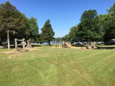
Shoal Bay offers 45 reservable campsites, most of which have electric hookups. Two large picnic shelters are also available. Amenities include a boat ramp, playground and hot showers.

Natural Features

Dardanelle Lake, sourced by the Arkansas River, spans 40,000 acres and boasts 315 miles of shoreline. The lake sits in the river valley between the Ozark and Ouachita National Forests.

Nearby Attractions

Bona Dea Trails and Sanctuary, with nearly 86 acres of wetlands and low woods, provide an ideal habitat for native wildlife. Visitors can explore the area on the 6 mile trail system.

Reservation

More from CampingHiking.net:

RAINBOW BAY, Oregon Campground Images, Info & Reservations

Directions From Klamath Falls travel 33 miles northwest on Highway 140. Turn south on Forest Road 3701 and continue .6 miles to the campground. Phone 866-201-4194 Activities BIKING, BOATING, CAMPING, FISHING, HIKING, SWIMMING SITE Keywords RABA,LAKE OF THE WOODS,WINEMA NF – FS Related Link(s) Rec Area Info & Images Oregon

COLTON GUARD STATION, Utah Campground Images, Info & Reservations

Directions Follow the mileage indications below and look for signs when traveling to Colton Guard Station. Leave with plenty of time to arrive at the guard station before dark. From Vernal, travel north on U.S. Highway 191/Vernal Avenue for approximately 20 miles. Turn left (west) on Forest Road 020. A

FREMONT POINT CABIN, Oregon Campground Images, Info & Reservations

Directions Summer Travel: From the Paisley Ranger District Office in Paisley, Oregon: Travel north on State Route 31 for 34.2 miles, between mile posts 64 and 65, turn left (west) onto the graveled Forest Service Road (FSR) 2901. Follow FSR 2901 for 16.1 miles. Turn left (east) on FSR 034

BABY DOE, Colorado Campground Images, Info & Reservations

Directions From Leadville, Colorado, drive west on County Road 4 about 3.5 miles, turn right on County Road 9C and follow signs to Baby Doe Campground. Phone 719-486-0749 (INFORMATION ONLY, NO RESERVATIONS) Activities BOATING, CAMPING, FISHING, HIKING, WATER SPORTS Keywords BABY,TURQUOISE LAKE,LEADVILLE,PIKE AND SAN ISABEL NF- FS Related Link(s) Rec

HIGH VIEW, Texas Campground Images, Info & Reservations

Directions From Ennis, Texas: From Interstate 45, exit onto U.S. Highway 287 Bypass (Exit #247). Travel 4.5 miles and exit at the Bardwell Lake exit sign. Turn left onto Highway 34 and go 2.5 miles southwest. After crossing the Bardwell Lake bridge, take the first left onto High View Park

RATTIN CAMPGROUND, Montana Campground Images, Info & Reservations

Directions Rattin Campground is located 60 miles northeast of Cooke City, MT and the northeast gate to Yellowstone National Park. It is 7 miles south of Red Lodge, MT. On U.S. Highway 212, turn off at Rattin Campground Road (Forest Road 379; formerly Eastside Road) and proceed 0.5 miles to