SOWELL CREEK, TX Campground Reservation, Info, Images, Map, Directions

SOWELL CREEK, Texas Campground Images, Info & Reservations

Directions

From Comanche, Texas, take Highway 67/377 east for 12 miles to the town of Proctor. Turn left on FM 1476 west and continue 2 miles to Recreation Road 6. Turn left and continue for 1/2 mile to the park entrance.

Phone

254-879-2322

Activities

BOATING, CAMPING, FISHING, HIKING, SWIMMING SITE

Keywords

SOWE,PROCTOR LAKE,LAKE PROCTOR,SOLE CREEK,SEWELL CREEK,PROCTOR LAKE

Related Link(s)

Rec Area Info & Images

Texas State Tourism

Texas State Road Conditions

Overview

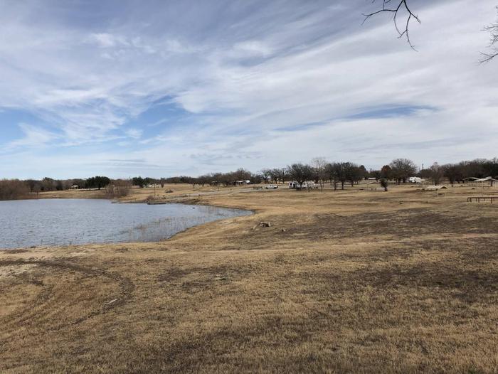
Sowell Creek Park is nestled within the beautiful Cross Timbers Region of Texas and located on the east side of Proctor Lake. Sowell Creek appeals to sportsmen, birdwatchers, naturalists or those simply wanting to relax in the outdoors.

Recreation

Sowell Creek offers families and friends with an excellent venue to enjoy the outdoors. The park offers overnight camping as well as two day-use areas for picnicing and several swim beaches for folks to soak up the sun and enjoy the beautiful lake water. Fishing is Proctor Lake’s main attraction: anglers enjoy the lake’s tremendous populations of Bass, Crappie, and Catfish. The lake is also recognized as one of the best Hybrid Striped Bass fishing areas in the state. Sowell Creek offers two boat ramps that provides guests with easy access to the lake. Also, two fishing docks are located within the park to provide guests with further fishing opportunities. High Point Park, located a few miles from Sowell Creek on FM 1496 (31.999944, -98.470486), offers more than 10 miles of hiking and equestrian trails.

Facilities

Sowell Creek offers 61 campsites and one group site during the summer (April – September); and 30 campsites during the winter (October – March). Campsites are equipped with electric hookups ranging from 50 amp, 30 amp, and 20 amp; water hookups; sewer hookups; and a covered picnic table. Amenities include flush and pit toilets, showers, drinking water and a dump station thus creating a comfortable camping environment for visitors.

Natural Features

Large, open grassy areas; Black Willow; and Buttonbush characterize the park:. Shade is sparse, but lake views are plentiful.

Nearby Attractions

The nearby town of Comanche, Texas offers historical attractions, antique stores. museums, events and more.

Reservation

More from CampingHiking.net:

SIBLEY LAKE, Wyoming Campground Images, Info & Reservations

Directions From Dayton, Wyoming, take U.S. Highway 14 southwest about 25 miles to the campground. Phone 406-587-9054 Activities BIKING, BOATING, FISHING, HIKING, VISITOR CENTER, WILDLIFE VIEWING, CANOEING, BIRDING Keywords SIBL,BIGHORN NF – FS Related Link(s) Rec Area Info & Images Overview Sibley Lake Campground is located at Sibley Lake along

WEST PARK (OR), Oregon Campground Images, Info & Reservations

Directions From Highway 730 turn north on Devore Road, at the stop sign turn left and continue down the hill, turn right onto Third Street and West Park will be about a half a mile down on your left. Phone 541-922-2268 Activities PICNICKING, DAY USE AREA Keywords Related Link(s) Rec

BIG ROCK GROUP, Utah Campground Images, Info & Reservations

Directions The campground is located 20 miles west of Huntington, Utah, along Utah Highway 31. Phone (435)384-2372 Activities BIKING, CLIMBING, CAMPING, FISHING, HIKING, HUNTING, WILDLIFE VIEWING Keywords BIGR,MANTI-LASAL NF -FS Related Link(s) Rec Area Info & Images Utah State Road Conditions Utah State Tourism Overview Big Rock Group Campground is

THIRD CREEK GROUP SITE, Idaho Campground Images, Info & Reservations

Directions From Malad, travel 3.5 miles north on I-15 to exit 17. Turn east onto Weston Highway and continue for 7 miles to Upper Deep Creek Reservoir. Turn left on Forest Road 231. Go one mile to Third Creek Group Site Campground. Phone 208-236-7500 Activities BIKING, CAMPING, HIKING, HORSEBACK RIDING,

CHIPPEWA LOOP, Minnesota Campground Images, Info & Reservations

Directions From Cass Lake, Minn., take U.S. Highway 2 east for 4 miles, to the Norway Beach Recreation Area. Turn left and follow the campground road until the signs indicate the Chippewa Loop. Phone 218-335-8600 Activities BIKING, BOATING, HISTORIC & CULTURAL SITE, CAMPING, INTERPRETIVE PROGRAMS, FISHING, WATER SPORTS, SWIMMING SITE

WHITE SULPHUR SPRINGS CABIN, Alaska Campground Images, Info & Reservations

Directions Accessible year round, weather permitting. Located 65 miles northwest of Sitka on Chichagof Island within the West Chichagof-Yakobi Wilderness Area. Boat access is possible with anchorage in Mirror Harbor, where 0.9-mile White Sulphur Springs Trail leads to the cabin; however, local knowledge is recommended before attempting anchorage there. White