ASPEN HOLLOW GROUP, CA Campground Reservation, Info, Images, Map, Directions

ASPEN HOLLOW GROUP, California Campground Images, Info & Reservations

Listen

Directions

From Fresno, California, take Highway 180 east to Grants Grove. Drive approximately 12 miles, then take a right onto Hume Road and continue 4 more miles, passing Christian Camps. Take a right at the Aspen Hollow sign. Go 3/4 mile reaching the entrance of the campground.

Phone

559-335-2232

Activities

BOATING, CAMPING, FISHING, SWIMMING SITE

Keywords

ASPH,GIANT SEQUOIA NAT. MONUMENT,SEQUOIA NF – FS

Related Link(s)

Rec Area Info & Images

Forest Service Concessionaire

California State Road Conditions

California State Tourism

Overview

Aspen Hollow Group sits at an elevation of 5,300 feet within the Giant Sequoia National Monument, adjacent to Kings Canyon National Park. The campground sits just one mile from Hume Lake, an 87-acre man-made lake in the Kings River Watershed.

Recreation

In addition to hiking the sequoia groves, visitors enjoy swimming, trout fishing and boating at nearby Lake Hume. The trails in the Monument are open to hikers, horses and bikes, however bikes are not permitted in wilderness areas.

Facilities

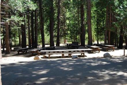
The campground accommodates up to 100 people and has back-in spaces for 35 vehicles.

Vault toilets, drinking water, laundry facilities and food storage lockers are provided.

The Giant Sequoia Mercantile offers a wide variety of books, maps, gifts, local art, camping supplies and other merchandise.

This facility is operated by Sequoia Recreation, a division of California Land Management and comments are welcome; comment forms are available from campground hosts or online.

Natural Features

The Sequoia National Forest, located at the southern end of the Sierra Nevada in central California, takes its name from the giant sequoia, the world’s largest tree, which grows in more than 30 groves on the Forest’s lower slopes.

The Forest comprises about 1.1 million acres, and elevations range from about 1,000 to 12,000 feet, creating precipitous canyons and mountain streams with spectacular waterfalls such as Salmon Creek Falls near Fairview and Grizzly Falls on the Kings River.

Reservation

More from CampingHiking.net:

ANGEL LAKE, Nevada Campground Images, Info & Reservations

Listen Directions Take Interstate 80 to the West Wells exit. Turn south on Angel Lake Road (State Route 231) and travel 12 miles to the end of the road at Angel Lake. Phone 775-752-3357 Activities BOATING, CAMPING, FISHING, HIKING, WILDLIFE VIEWING Keywords ANGL,RUBY MOUNTAINS,HUMBOLDT-TOIYABE NF-FS Related Link(s) Rec Area Info

CLEAR CREEK (AL), Alabama Campground Images, Info & Reservations

Listen Directions From Jasper travel approx. 5 miles north on State Road 195 to Manchester, 8.5 miles north on County Road 27 to entrance.  From Double Springs travel approx. 12 miles south on State Road 195 to Lamon Chapel Road go to the end and turn left on County Road

PIGOT BAY CABIN, Alaska Campground Images, Info & Reservations

Listen Directions The cabin is located on the southwest shore near the head of Pigot Bay, northeast of Whittier. Access by a float plane is a 40 minute trip from Anchorage or a 60 minute trip from Cordova. By boat, it is a 18 mile trek from Whittier. Check local

SHEEP PASS GROUP, California Campground Images, Info & Reservations

Listen Directions Take Interstate 10 to Route 62. From the town of Joshua Tree turn south on Park Blvd. and continue through the West Entrance. The campground is 13 miles from the entrance station and the city of Twentynine Palms. Phone 760-367-5554 Activities CLIMBING, CAMPING, HIKING, PICNICKING Keywords CG40,Joshua Tree

BROOKEN COVE, Oklahoma Campground Images, Info & Reservations

Listen Directions From Enterprise, Oklahoma, take Highway 71 north for 5 miles and follow signs to the campground. Phone 918-799-5843 Activities BOATING, CAMPING, FISHING, HIKING, SWIMMING SITE Keywords BRCO,EUFAULA LAKE,EUFAULA LAKE Related Link(s) Rec Area Info & Images Oklahoma State Tourism Oklahoma State Road Conditions Overview Brooken Cove Campground sits

ASPEN (AZ), Arizona Campground Images, Info & Reservations

Listen Directions From Payson, take Highway 260 northeast toward Heber. Take a left at the sign for Woods Canyon Lake (Rim Road/Forest Road 300). Follow for about 5 miles and turn right onto the paved road at the sign toward Woods Canyon Lake (there is no road sign). Aspen Campground