VERMILLION, CA Campground Reservation, Info, Images, Map, Directions

VERMILLION, California Campground Images, Info & Reservations

Directions

From Clovis, take Highway 168 east to Shaver Lake. Continue through Shaver Lake to Huntington Lake. At the east end of Huntington Lake, turn right on the Kaiser Pass Road (at Eastwood Visitor Center). Travel 17 miles to the Edison Lake Road. Turn left toward Edison Lake and travel 7 miles to the campground.

Phone

559-893-2111

Activities

BOATING, CAMPING, INTERPRETIVE PROGRAMS, FISHING, HIKING, HORSEBACK RIDING, SWIMMING SITE

Keywords

VERI,HIGH SIERRA,EDISON LAKE,SIERRA NF – FS

Related Link(s)

Rec Area Info & Images

Forest Service Concessionaire

California State Tourism

California State Road Conditions

Overview

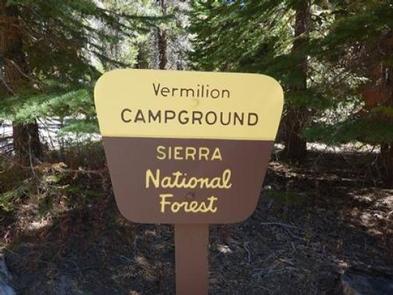
Vermillion Campground is located on the northwest shore of Edison Lake, in a shady stand of Ponderosa pine. Most sites provide lake views. The campground is ideal for tents, as well as small RVs. Visitors can enjoy mountain views of the surrounding John Muir and Ansel Adams Wilderness areas.

Recreation

Edison Lake has a free public boat launch. Canoeing and kayaking near the shoreline are popular activities. Anglers can fish for rainbow, brown or brook trout. Sandy beaches within the campground provide lake access for swimming.

Campfire programs are offered throughout the summer. Numerous hiking and equestrian trails are in the area.

Facilities

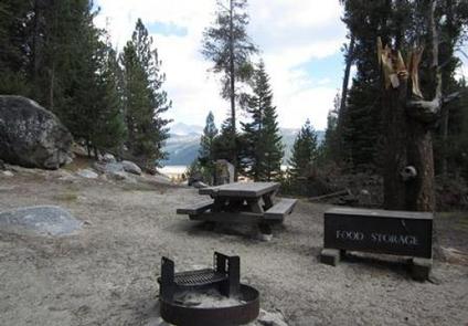
Each campsite has a picnic table, campfire ring and bear-proof food storage locker, all set off a bit from the parking spur. Some sites are sloped and not suitable for tent camping. Vault toilets are provided. A water spigot is located on-site, but boiling the water is recommended.

Limited supplies and pay showers are available at the Vermillion Valley Resort, which is within walking distance.

Natural Features

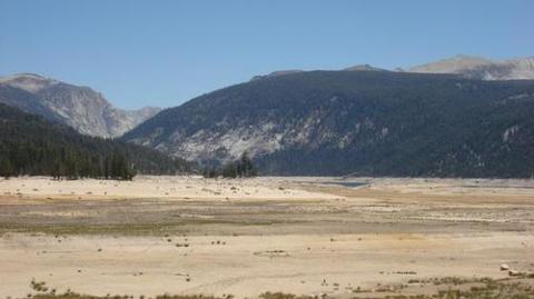
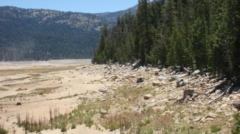
The Sierra National Forest, located on the western slope of the central Sierra Nevada, is known for its spectacular mountain scenery and abundant natural resources.

The terrain includes rolling, oak-covered foothills, heavily forested middle elevation slopes and the starkly beautiful alpine landscape of the High Sierra.

Nearby Attractions

Vermillion Campground is an excellent base for exploring the Ansel Adams or John Muir Wilderness Areas. The Vermillion Valley Resort offers ferry rides across the lake to trails within the Ansel Adams Wilderness.

Reservation

More from CampingHiking.net:

OAK PARK DAY USE, Texas Campground Images, Info & Reservations

Directions From Waco or Corsicana, Texas, take State Highway 31 to the intersection with FM 667. Turn north on FM 667 and travel about 1.5 miles to the park entrance on the left side of the road. Phone 254-578-1431 Activities SWIMMING Keywords Oak park Related Link(s) Rec Area Info &

BLACK CANYON, New Mexico Campground Images, Info & Reservations

Directions From downtown Santa Fe, New Mexico, travel north on Washington Avenue to Artist Road (Hyde Park Road/State Route 475) and turn right. Continue for 7 miles to Black Canyon. Phone 505-753-7331 Activities BIKING, CAMPING, HIKING Keywords BOYD,SANTA FE NF – FS Related Link(s) Rec Area Info & Images New

WOODBINE CAMPGROUND, Montana Campground Images, Info & Reservations

Directions Take Montana Highways 78 and 419 south of Columbus (on 1-90) 43 miles west of Billings, Montana. Phone 406-587-9054 Activities BIKING, CAMPING, FISHING, HIKING, WILDLIFE VIEWING Keywords None Related Link(s) Rec Area Info & Images Overview Woodbine Campground is remotely located adjacent to the Absaroka-Beartooth Wilderness in southwestern Montana,

BUTTERMILK, Idaho Campground Images, Info & Reservations

Directions From West Yellowstone, Montana, take Highway 20 south, southwest for approximately 25 miles and from Ashton, Idaho, take Highway 20 north for approximately 27 miles. Turn west onto the Kilgore-Yale Road #030 (across from Elk Creek Gas Station) and go about 2 miles to the Buttermilk Loop Road #126.

PICKENSVILLE CG (PICKENSVILLE AL), Alabama Campground Images, Info & Reservations

Directions From Tuscaloosa, Alabama, take Highway 82 west to the junction with Highway 86. Turn left on 86 west to Pickensville. The entrance road to the campground is 2.5 miles from the yellow caution light. Phone 205-373-6328 Activities BIKING, CAMPING, INTERPRETIVE PROGRAMS, FISHING, HIKING, HUNTING, WILDLIFE VIEWING Keywords PICK,TENNESSEE- TOMBIGBEE