MAMMOTH POOL, CA Campground Reservation, Info, Images, Map, Directions

MAMMOTH POOL, California Campground Images, Info & Reservations

Directions

From Fresno, California, take Highway 41 north. Turn northeast on Forest Road 200 and pass through North Fork. Take Minarets Road east, follow it 37 miles, turn right on Mammoth Pool Road and follow it 4 miles to Mammoth Pool Campground.

Phone

559-642-3212

Activities

BOATING, CAMPING, FISHING, HIKING, WILDLIFE VIEWING

Keywords

MAMM,SIERRA NF – FS

Related Link(s)

Rec Area Info & Images

Forest Service Concessionaire

California State Tourism

California State Road Conditions

Overview

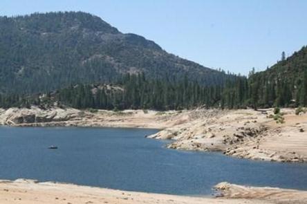
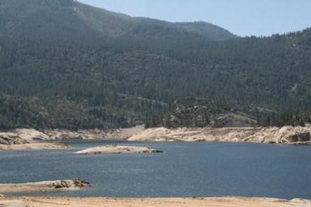
Mammoth Pool Campground is located half a mile from the recreation area at Mammoth Pool Reservoir. This primitive campground winds through a stand of Ponderosa pine and cedar trees along the San Joaquin River in the midst of a mountainous landscape.

Recreation

Mammoth Pool Reservoir offers a variety of recreational activities, including fishing, boating, hiking and wildlife viewing. A boat ramp is available at the reservoir.

Hikers can access the nearby French Trail, a 12.7-mile foot trail that provides access to the Ansel Adams Wilderness.

Facilities

Each campsite has a picnic table, grill and campfire ring. Vault toilets are provided, but campers must bring drinking water.

Campers will find a pay phone, gas and camping supplies at nearby Wagner’s Mammoth Pool Resort.

Natural Features

The Sierra National Forest, located on the western slope of the central Sierra Nevada, is known for its spectacular mountain scenery and abundant natural resources. The terrain includes rolling, oak-covered foothills, heavily forested middle elevation slopes and the starkly beautiful alpine landscape of the High Sierra.

Mammoth Pool Campground is located near the Ansel Adams Wilderness, known for its jagged peaks, including 13,157-foot Mt. Ritter, and numerous lakes and streams.

Nearby Attractions

A popular pastime in the area is to take a drive on the 83-mile Sierra Vista Scenic Byway.

Reservation

More from CampingHiking.net:

WEST POINT CABIN, Alaska Campground Images, Info & Reservations

Directions The West Point Cabin is located near the mouth of Portage Bay on Kupreanof Island. It is situated west of West Point, just around the point from Fredrick Sound. It is 18 miles by float plane or 24 miles by boat from Petersburg. The cabin can be found on

DEAD SWEDE, Wyoming Campground Images, Info & Reservations

Directions From Dayton, Wyoming, travel 26.5 miles west on U.S. Highway 14 to Burgess Junction. Continue 5 miles south on U.S. Highway 14, then turn east onto Forest Road 26 and travel about 5 miles east to the campground. Phone 406-587-9054 Activities BIKING, HISTORIC & CULTURAL SITE, CAMPING, FISHING, HIKING,

HAZELTON RECREATION AREA, North Dakota Campground Images, Info & Reservations

Directions From Bismarck, ND, take University Drive south (road becomes Highway 1804). Continue 25 miles south. Recreation area will be on the right side of the road. Phone 701-255-0015. FOR RESERVATIONS, PLEASE CALL 877-444-6777. Activities BOATING, CAMPING, FISHING, PICNICKING, PHOTOGRAPHY, WATER ACCESS, DISC GOLF Keywords HAZELTON RECREATION AREA (ND),HAZELTON CAMPGROUND,,HAZELTON

Dunewood Campground, Indiana Campground Images, Info & Reservations

Directions Please use this link to get to the directions page on our website. https://www.nps.gov/indu/planyourvisit/directions.htm Phone 219-395-1882 Activities BIKING, BOATING, CAMPING, INTERPRETIVE PROGRAMS, FISHING, HIKING, PICNICKING, VISITOR CENTER, WILDLIFE VIEWING, SWIMMING SITE, INFORMATION SITE, ENVIRONMENTAL EDUCATION, PHOTOGRAPHY, SWIMMING, KAYAKING, CANOEING, BEACHCOMBING, BIRDING, WATER ACCESS, EVENING PROGRAMS, GUIDED INTERPRETIVE WALKS, RECREATION