ROCK CREEK (SIERRA NATL FORES), CA Campground Reservation, Info, Images, Map, Directions

ROCK CREEK (SIERRA NATL FORES), California Campground Images, Info & Reservations

Listen

Directions

From Fresno, California, take Highway 41 north. Turn east on Forest Road 200 and pass through North Fork. Take Minarets Road east for 22 miles to Rock Creek Campground.

Phone

559-642-3212

Activities

BOATING, CAMPING, FISHING, HIKING, SWIMMING SITE

Keywords

ROCK,ROCK CREEK SIERRA NAT L FORES,SIERRA NF – FS,Rock,rock,rock creek

Related Link(s)

Rec Area Info & Images

California State Tourism

California State Road Conditions

Forest Service Concessionaire

Overview

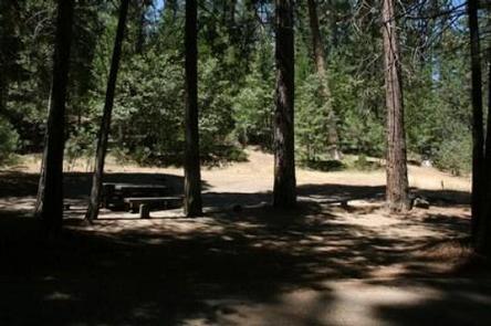
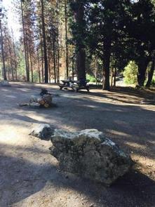
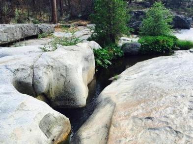
Rock Creek Campground sits on a large, sandy flat under a grove of oak, pine and cedar trees. The sites are divided into three sections, with Rock Creek running through the middle. One section of the camp sits nearest the access road; the other two sections can be reached via a bridge over Rock Creek. On this side, the largest section is located in closest to the swimming holes and rock water slide in the area.

Recreation

Swimming holes can be found along the creek, and the campground’s proximity to Mammoth Pool Reservoir provides even more recreational activities, including fishing, boating and hiking.

Facilities

Each campsite has a picnic table and campfire ring with grill. Parking spurs are paved and dirt-surfaced. Vault toilets and drinking water are provided. Supplies can be purchased at Wagner’s Mammoth Pool Resort.

Natural Features

The Sierra National Forest, located on the western slope of the central Sierra Nevada, is known for its spectacular mountain scenery and abundant natural resources.

The terrain includes rolling, oak-covered foothills, heavily forested middle elevation slopes and the starkly beautiful alpine landscape of the High Sierra.

Rock Creek Campground is located close to Mammoth Pool Reservoir near the Ansel Adams Wilderness. This area is known for its jagged peaks, including 13,157-foot Mt. Ritter, and numerous lakes and streams.

Nearby Attractions

The campground is located off the Sierra Vista Scenic Byway, an 83-mile driving route with views of some of the Sierra National Forest’s most striking landmarks.

Reservation

More from CampingHiking.net:

PIONEER TRAIL, California Campground Images, Info & Reservations

Listen Directions From Sonora, California, take Highway 108 east for about 30 miles. Exit at Pinecrest Lake and turn right on Dodge Ridge Road. Continue 1 mile to Pioneer Trails Campground, located on the left. Phone 209-965-3474 Activities BOATING, CAMPING, FISHING, HIKING, SWIMMING SITE Keywords PION,STANISLAUS NF -FS Related Link(s)

STILLHOUSE, Texas Campground Images, Info & Reservations

Listen Directions From Interstate 35 in Belton, Texas take State Highway 190 west to the Simmons Road exit. Exit and turn left under 190 onto Simmons Road. Proceed about three miles to the park. Phone 254-939-6741 Activities BOATING, CAMPING, FISHING, SWIMMING SITE Keywords STIL,STILLHOUSE HOLLOW PARK,STILLHOUSE HOLLOW Related Link(s) Rec

SWINGING BRIDGE, Idaho Campground Images, Info & Reservations

Listen Directions From Horseshoe Bend, ID, take State Rt. 55 north for 21.5 miles to the campground sign. Turn left after the sign into the campground(on west side of highway). Phone 541-351-1182 Activities BOATING, CAMPING, FISHING Keywords SWIN,PAYETTE RIVER HIGHWAY 55,BOISE NF – FS Related Link(s) Rec Area Info &

SANDERS COVE, Texas Campground Images, Info & Reservations

Listen Directions From Paris, TX, take HWY 271 north 12 miles to FM 906 W and follow it 1 mile to CR 35920. Turn left into the park following signs. Phone 903-732-4955 Activities BIKING, BOATING, CAMPING, FISHING, HIKING, HUNTING, SWIMMING, WATER ACTIVITIES, WATER ACCESS, ACCESSIBLE SWIMMING Keywords SACV,PAT MAYSE LAKE,SANDERS

MEADOW RIDGE, Colorado Campground Images, Info & Reservations

Listen Directions From Colorado Springs, drive west on Highway 24 for about 24 miles to Woodland Park. Turn right (north) on Baldwin St. (which becomes Rampart Range Road). Drive about 2 miles to Loy Creek Road, turn right, and then take another right on Forest Road 300 (Rampart Range Road).

SHOUSE FORD, Arkansas Campground Images, Info & Reservations

Listen Directions From Interstate 30, take exit 78 and merge onto State Highway 7 north to Bismarck. Turn left on State Highway 84 and go 9 miles west to Point Cedar. Turn left onto Shouse Ford road and continue 4 miles to the campground. Phone 870-246-5501 Activities BOATING, CAMPING, FISHING,