QUAKING ASPEN, CA Campground Reservation, Info, Images, Map, Directions

QUAKING ASPEN, California Campground Images, Info & Reservations

Directions

From Porterville, California, take Highway 190 East to Springville. Continue from Springville approximately 28 miles to the Quaking Aspen Campground.

Phone

559-539-5230

Activities

BIKING, CAMPING, DAY USE AREA

Keywords

QUAK,QA,GIANT SEQUOIA NAT. MONUMENT,SEQUOIA NF – FS

Related Link(s)

Rec Area Info & Images

California State Tourism

California State Road Conditions

Forest Service Concessionaire

Overview

Quaking Aspen Campground is situated in the Giant Sequoia National Monument near numerous distinctive sequoia groves, including McIntyre Grove and Freeman Creek Grove, at an elevation of 7,000 feet.

Recreation

Visitors can explore nearby sequoia groves. Bear Creek Grove has a trail that winds through the Belknap Complex along Bear Creek and the Tule River.

The Freeman Creek Grove is also a popular destination. At 1,425 acres, this immense unlogged grove features several large sequoias, including the President George Bush Tree.

There is fishing in area streams and the Tule River. For hiking, the Summit Trailhead is 10 miles north of the campground.

Facilities

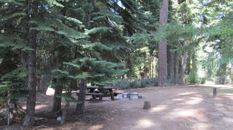
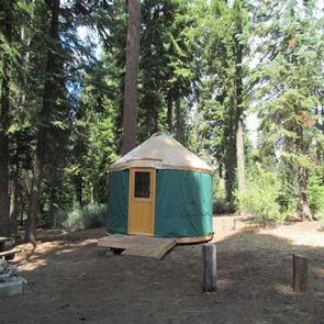
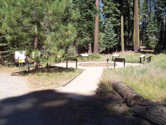
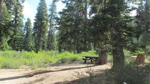
This popular campground includes three small group sites that accommodate up to 12 people per campsite, 30 standard sites, two cabin sites and four tent-only sites. Some sites overlook a meadow. An amphitheater, vault toilets and picnic areas are provided. Please note, there is limited turnaround space in this campground, restricting RVs longer than 26 feet in length.

This facility is operated by Sequoia Recreation, a division of California Land Management and comments are welcome; comment forms are available from campground hosts or online.

Natural Features

The Sequoia National Forest, located at the southern end of the Sierra Nevada in central California, takes its name from the giant sequoia, the world’s largest tree, which grows in more than 30 groves on the Forest’s lower slopes.

The Forest comprises about 1.1 million acres, and elevations range from about 1,000 to 12,000 feet, creating precipitous canyons and mountain streams with spectacular waterfalls such as Salmon Creek Falls and Grizzly Falls.

Nearby Attractions

The Trail of 100 Giants is 10 miles away. Possible day trips include Dome Rock and the Needles rock formation and lookout.

Reservation

More from CampingHiking.net:

BIG TRINITY CABIN, Idaho Campground Images, Info & Reservations

Directions Travel east from Boise, Idaho on I-84 to Mountain Home. At I-84/Highway 20 junction, take Highway 20 east for 35 miles to Pine/Featherville turnoff. Travel north on Forest Highway 61 for 29 miles to Forest Road 172. Travel 15 miles northwest to Forest Road 129. Travel 3 miles to

SAN MIGUEL ISLAND, California Campground Images, Info & Reservations

Directions Boat transportation can be arranged with Island Packers from Ventura Harbor. Air transportation can be arranged with Channel Islands Aviation from Camarillo airport. To park headquarters in Ventura, California: Highway 101, exit Victoria or Seaward to Ventura Harbor. Phone 805-658-5730 Activities BOATING, HISTORIC & CULTURAL SITE, CAMPING, INTERPRETIVE PROGRAMS,

MILLER CABIN, Montana Campground Images, Info & Reservations

Directions From Townsend, Montana: Turn east from US Highway 287 onto US Highway 12 for approximately 3 miles. Turn north on State Highway 284 for approximately 15 miles. Turn northeast onto Forest Road 287, Confederate Gulch, travel on Forest Rd 287 for approximately 8 miles. Arrived at location. Junction of

CAGES BEND, Tennessee Campground Images, Info & Reservations

Directions From Nashville, TN, travel North on I-65 and take TN-386/Vietnam Veterans Blvd. Continue to exit 12, Big Station Camp Blvd. Turn right onto Big Station Camp Bldvd. Continue staight across Nashville Pike onto Cages Bend Road. Take Cages Bend Road to Benders Ferry Road. The recreation area will be

DIABLO, California Campground Images, Info & Reservations

Directions From Sierraville, travel south on Highway 49 for 18 miles. Turn right at Bassett and continue just over a mile to the Sardine Lake turnoff. Turn right at Packer Lake/Forest Road 93 and continue to the campground. Phone (530)478-6253 Activities BIKING, BOATING, CAMPING, FISHING, HIKING, HUNTING, WILDLIFE VIEWING Keywords