CAMP THREE CAMPGROUND, CA Campground Reservation, Info, Images, Map, Directions

CAMP THREE CAMPGROUND, California Campground Images, Info & Reservations

Listen

Directions

From Highway 99 in Bakersfield, California, take Highway 178 east to Lake Isabella. From Lake Isabella take Highway 155 around the west side of the lake to the town of Kernville. Turn north on Sierra Way/Mountain 99 and continue 5 miles to the campground.

Phone

760-376-1815

Activities

BOATING, CAMPING, FISHING, HIKING

Keywords

CAMT,UPPER KERN CANYON,KERN RIVER,SEQUOIA NF – FS

Related Link(s)

Rec Area Info & Images

California State Road Conditions

Forest Service Concessionaire

California State Tourism

Overview

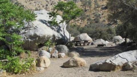
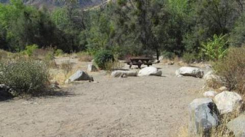
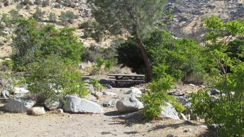
Camp Three Campground is set amidst oak and locust trees at an elevation of 2,800 feet on the Upper Kern River, offering countless recreational opportunities for visitors.

Recreation

Hiking, fishing, kayaking and rafting are popular activities in the Upper Kern River area.

Facilities

The campground consists of 52 paved sites and a group camp that accommodates up to 30 people for friends or family gatherings.

Drinking water, vault toilets, and campfire rings are all provided.

This facility is operated by Sequoia Recreation, a division of California Land Management and comments are welcome; comment forms are available from campground hosts or online.

Natural Features

The Sequoia National Forest, located at the southern end of the Sierra Nevada in central California, takes its name from the giant sequoia, the world’s largest tree, which grows in more than 30 groves on the Forest’s lower slopes.

The Forest comprises about 1.1 million acres, and elevations range from about 1,000 to 12,000 feet, creating precipitous canyons and mountain streams with spectacular waterfalls, such as Salmon Creek Falls near Fairview and Grizzly Falls on the Kings River.

Gray pines, scrub oaks, grass and dry climate shrubs cling to steep, canyon walls while cottonwoods and willows line the river’s edge.

Nearby Attractions

The Cannell Meadow National Recreation Trailhead is just north of Kernville. Day trips include the Sequoia National Park, Trail of a Hundred Giants, and numerous sequoia groves in the Sequoia National Monument.

The Giant Sequoia Mercantile offers a wide variety of books, maps, gifts, local art, camping supplies and other merchandise.

Reservation

More from CampingHiking.net:

CABIN CREEK CAMPGROUND, Montana Campground Images, Info & Reservations

Listen Directions From West Yellowstone, travel 8 miles north on Highway 191, then 14 miles west on Highway 287. Phone 406-646-1012 Activities BIKING, CAMPING, FISHING, HIKING, HUNTING, WILDLIFE VIEWING, PHOTOGRAPHY, MOUNTAIN BIKING, BERRY PICKING, STAR GAZING, BIRDING, WATER ACCESS, BACKPACKING, MUSHROOM PICKING Keywords None Related Link(s) Rec Area Info &

MAY CREEK CABIN, Montana Campground Images, Info & Reservations

Listen Directions From Wisdom, travel west on Highway 43 for about 16 miles to the May Creek Campground. Guests can park in the plowed parking area near the highway at the entrance to the campground during the winter. During the summer months, follow the campground road to the fence at

THIRD CREEK GROUP SITE, Idaho Campground Images, Info & Reservations

Listen Directions From Malad, travel 3.5 miles north on I-15 to exit 17. Turn east onto Weston Highway and continue for 7 miles to Upper Deep Creek Reservoir. Turn left on Forest Road 231. Go one mile to Third Creek Group Site Campground. Phone 208-236-7500 Activities BIKING, CAMPING, HIKING, HORSEBACK

COPPERAS CREEK, Texas Campground Images, Info & Reservations

Listen Directions From Comanche, Texas, take HWY 67/377 northeast for 5 miles, then turn left on FM 2861. Follow for 2.5 miles to the park entrance. Park entrance is on the North side of FM 2861. Phone 254-879-2498 Activities BOATING, CAMPING, FISHING, HIKING, HUNTING Keywords COPP,PROCTOR LAKE,LAKE PROCTOR,COPPERAS COVE,PROCTOR LAKE

ARLIE MOORE, Arkansas Campground Images, Info & Reservations

Listen Directions From Interstate 30, take exit 78 and merge onto State Highway 7 north for 9 miles. Turn left onto Arlie Moore Road and continue 2 miles to campground. Phone 870-246-5501 Activities BOATING, CAMPING, FISHING, HIKING, DAY USE AREA, SWIMMING SITE Keywords ARLI,DEGRAY LAKE,DEGRAY LAKE Related Link(s) Rec Area