DENVER CABOOSE CABIN, AK Campground Reservation, Info, Images, Map, Directions

DENVER CABOOSE CABIN, Alaska Campground Images, Info & Reservations

Listen

Directions

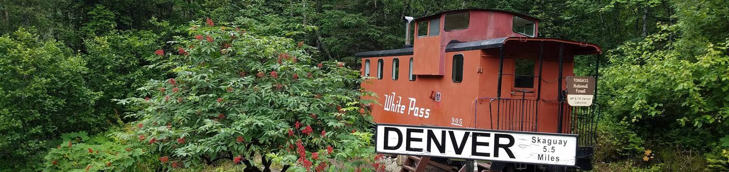
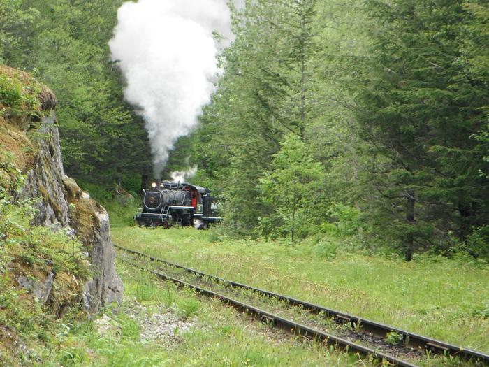
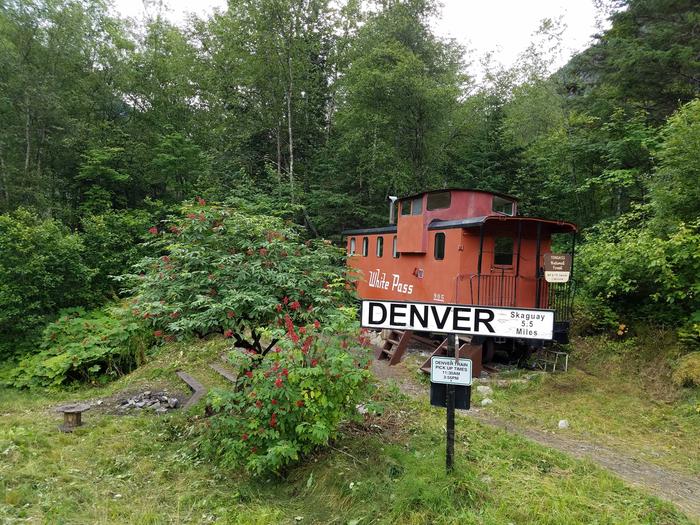
The cabin is approximately 5.5 miles north of Skagway along the East Fork of the Skagway River. The cabin is beside the railroad tracks at the Denver Glacier Trailhead. Access is via the White Pass and Yukon Route Railroad from May 1 through September 30. Make reservations at least 24 hours in advance for train transportation. Rate information and reservations are available by calling the railroad at (800) 343-7373.

Phone

907-586-8800

Activities

CAMPING, HIKING, WILDLIFE VIEWING

Keywords

DEOO,TONGASS NF – FS

Related Link(s)

Rec Area Info & Images

Alaska State Road Conditions

Alaska State Tourism

Overview

This unique cabin is a refurbished 1960s railroad caboose that is retired from the White Pass and Yukon Railroad. It is an ideal base for outdoor enthusiasts who want to hike to the Denver Glacier. Access to Denver Caboose Cabin is via the White Pass and Yukon Railroad from May 1 to September 30. The cabin is closed to reservations in the off-season, since the surrounding area is owned by the railroad. Visitors are responsible for their own travel arrangements and safety and must bring several of their own amenities.

Recreation

A 4.5-mile trail to Denver Glacier starts at the cabin site. The trail follows a river and has many scenic overlooks. The nearby terrain is rugged and brushy.

Facilities

The cabin sleeps six people and contains a double bunk and four single bunks. This includes a bunk in the nicknamed “observatory penthouse” that has windows on all sides and an access ladder. Other amenities include a table with benches, an oil heater (#1 stove oil), food preparation space, a campfire ring and an outhouse. Water and electricity are not provided. Water is available from a nearby stream uphill from the cabin, but visitors should be sure to treat water before drinking or cooking with it ( water safety tips ). It is recommended that visitors bring their own water supply. Heating oil is not provided, so visitors must supply their own. One gallon of #1 stove oil will last about a day on the lowest heat setting. Other items to bring include sleeping bags, sleeping pads, a cooking stove, lanterns or flashlights, cookware, plates, utensils, food, toilet paper, garbage bags, a fire extinguisher and fire starter. Visitors are expected to pack out trash and clean the cabin before leaving ( click here for more cabin details).

Natural Features

Denver Caboose Cabin offers excellent views of the East Fork Skagway River and the Sawtooth Mountains. It is surrounded by spruce and hemlock rainforest. Black bears and moose are common in this area ( bear safety information ). Mountain goats can frequently be seen with binoculars.

Reservation

More from CampingHiking.net:

DAY LAKE, Wisconsin Campground Images, Info & Reservations

Listen Directions From Clam Lake, Wisconsin, travel a mile north on Highway GG. Phone (715) 634-4821 OR (715) 264-2511 Activities BOATING, CAMPING, FISHING, SWIMMING SITE Keywords DLAK,CHEQUAMEGON-NICOLET NF – FS Related Link(s) Rec Area Info & Images Overview Day Lake Campground is situated in northwestern Wisconsin, not far from the

COLUMBINE CAMPGROUND (NM), New Mexico Campground Images, Info & Reservations

Listen Directions Five miles east of Questa, New Mexico via NM highway 38. Phone 435-245-6521 Activities CAMPING, FISHING, HIKING, VISITOR CENTER, WILDLIFE VIEWING Keywords Related Link(s) Rec Area Info & Images New Mexico State Road Conditions New Mexico State Tourism Overview Columbine Campground is located between Questa and Red River,

SAGEHEN CREEK, Idaho Campground Images, Info & Reservations

Listen Directions From Horseshoe Bend, Idaho take Highway 52 for 9 miles west to the junction with the Sweet/Ola Highway. Turn north and travel 16 miles to Ola, Idaho. Travel north through Ola and follow FS Rd 618, 18 miles to Sagehen Reservoir (FS Road 626). Turn right and continue

SNOWBANK CAMPGROUND, Montana Campground Images, Info & Reservations

Listen Directions From Livingston, travel south on Highway 89 for 16 miles to the Mill Creek Road/Forest Road 486 (Pray turnoff). Turn left (east) onto Mill Creek Road, cross the East River Road (Highway 540) and continue east for 11 miles to the campground. From Gardiner, take Highway 89 north

COLD SPRINGS PEAK CABIN, Idaho Campground Images, Info & Reservations

Listen Directions From Missoula, Montana, drive to Greer, Idaho. Follow State Highway 11 to Weippe. Continue on toward Pierce. Turn right onto French Mountain Road 250. Follow Road 250 (paved for 17 miles, gravel thereafter) to the Bungalow Bridge, which spans the North Fork Clearwater River. Turn right and remain

Willows Campground, Washington Campground Images, Info & Reservations

Listen Directions From Naches, Washington, take Route 12 west 4.4 miles to the intersection with State Route 410. Turn left at the intersection, staying on Route 12. Travel 15 miles to campground on the left. Phone 541-338-7869 Activities CAMPING, FISHING, HIKING Keywords WLLS,RIMROCK LAKE,TIETON RIVER,OKANOGAN – WENATCHEE NF -FS,Flaming Gorge