
Directions
The cabin is accessible by float plane only. It is located approximately 44 air miles northeast of Ketchikan on the mainland, north of Wilson Arm. The cabin sits on the south end of Wilson Lake. This cabin is in a designated Wilderness area, and access by helicopter is illegal. Refer to USGS map Ketchikan B-2 and C-2. In fall, winter, and early spring, the cabin may be inaccessible due to frozen lake surface (float planes cannot land). Please contact the Ketchikan-Misty Fjords Ranger District for information prior to making reservations during these periods.
Phone
907-225-2148
Activities
BOATING, CAMPING, FISHING, WILDLIFE VIEWING
Keywords
WILN,TONGASS NF – FS
Related Link(s)
Overview
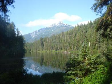
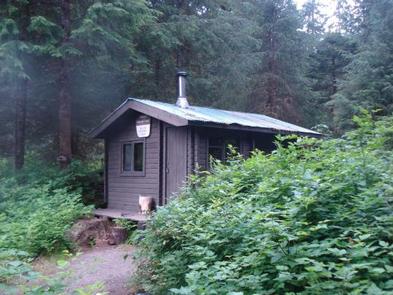
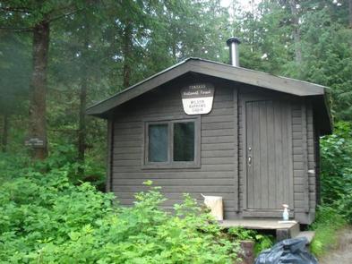
Wilson Narrows Cabin is situated on the south end of Wilson Lake approximately 44 air miles northeast of Ketchikan. The cabin is available year-round and makes an excellent base for experiencing this corner of Alaska with its recreation options, beautiful scenery and abundant wildlife.
The cabin is remote and does not have electricity, indoor plumbing or cell phone service. It is accessible only by float plane, depending on conditions. Visitors are responsible for their own travel arrangements and safety, and must bring several of their own amenities.
Recreation
Wilson Lake is an angler’s paradise, offering excellent cutthroat trout, Dolly Varden and kokanee salmon fishing at the lake outlet.
A 14-foot aluminum skiff with oars is provided for rowing around the lake, but visitors must provide their own life jackets.
Facilities
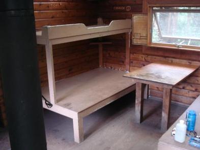
This 12×14-ft. ( pan-abode style ) cabin accommodates 6 people with 2 single and 2 double bunks. Other amenities include a table and benches, cooking counter, food storage and a broom with dustpan. A wood stove is provided for heat, along with a splitting maul. An outhouse is located nearby. NOTE: Firewood may be available, but visitors are encouraged to contact the Ketchikan Misty Fjords Ranger District to check the status of the woodshed. Drinking water is not available at the cabin. It is recommended that visitors bring their own water supply. Water is also available from the lake, but should be treated before drinking or cooking with it (water safety). Visitors should also bring sleeping bags, sleeping pads, cooking gear, lanterns or flashlights, food, toilet paper, garbage bags, a fire extinguisher and fire starter. Rain gear and boots are recommended. Visitors are expected to pack out their trash, gear and food and clean the cabin before leaving ( more cabin details ).
Natural Features
The cabin is situated within Misty Fiords National Monument Wilderness on the shore of long and narrow Wilson Lake, which was carved out by glaciers. Cabin visitors can enjoy looking out over the placid lake, which is surrounded by rugged mountain peaks and evergreen forest.
Mountain goat, Sitka black-tailed deer, black bear and brown bear are common to the area (bear safety). A variety of birds may be seen in and around Wilson Lake.