
Directions
At mile 52.6 of the Sterling Highway turn into Russian River Campground and travel 1 mile to Russian Lakes Trailhead, follow the Russian Lakes Trail 3.3 miles turning onto the Barber Cabin Spur trail at mile 2.5. The route is 4.2 miles in the winter and follows the campground entrance road, the summer trail for 1.8 miles, then a marked winter route and across the frozen surface of Lower Russian Lake.
Via floatplane, the cabin is 25 minutes from Seward or Cooper Landing. Refer to USGS topographic map Seward B8. Maps are available online or by calling the Seward Ranger District at 907-288-3178.
Winter travelers need to be able to evaluate avalanche and over-ice travel conditions. For current travel conditions, call the district office. Motorized access is prohibited year-round. The trail is closed to horse/pack stock from April 1 to June 30.
See link below for Russian Lakes Trail information:
https://www.fs.usda.gov/Internet/FSE_DOCUMENTS/fseprd564962.pdf
Phone
907-288-3178
Activities
BIKING, CAMPING, FISHING, HIKING, WINTER SPORTS
Keywords
BARB,LOWER RUSSIAN LAKE CABIN,CHUGACH NF – FS
Related Link(s)
Overview
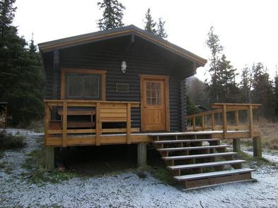
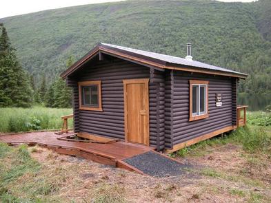
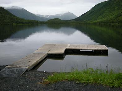
Barber Cabin offers a remote lodging experience on the Eastern Kenai Peninsula of south-central Alaska. The rustic cabin has few amenities, but provides access to the great outdoors and a scenic mountain lake. There is great fishing in Lower Russian Lake, and hiking and biking trails abound. Wildlife viewing is good in the area as well, though visitors should watch out for bears.
The cabin can be accessed by hiking, biking, skiing, horseback or floatplanes. Visitors are responsible for their own travel arrangements and safety, and must bring several of their own amenities.
Recreation
Visitors enjoy boating and rainbow trout fishing on Lower Russian Lake. A rowboat with oars is provided at the cabin. Fishing equipment is not provided and permits are required to fish in the state (click here for Alaska Department of Fish & Game regulations). The lake freezes during winter months.
A variety of trails and unexplored areas exist near the cabin. Hikers and bikers can explore varying terrain, including muskeg, meadows and high-canopied forest along the 21-mile Russian Lakes Trail, toward the Upper Russian Lake Cabin. There is a high avalanche hazard on Russian Lakes Trail in the winter (learn about avalanche safety). Snow can remain on the trail until early June. Hunting is popular along the trail and in the surrounding area.
Facilities
The accessible log cabin has bunk space for six and a maximum occupancy of eight people. It is equipped with counter space, table, benches and a wood stove for heat. A splitting maul and hand saw are available. An outhouse is also provided.
There is no electricity, potable water, mattresses, bedding, cooking utensils or cut firewood at the cabin. Visitors should bring sleeping bags and pads, a cook stove, cooking gear and food. Water taken from the lake should be treated or boiled before consumption.
Natural Features
The cabin is close to Cooper Landing off the Sterling Highway, in a fairly flat area on the east shore Lower Russian Lake. It is surrounded by a scattered spruce forest, and meadows with shrubs and brush, providing scenic mountain views.
A variety of wildlife make its home in the area, including moose, black and brown bears and wolves. The surrounding area has a particularly high concentration of bears. For more information on access and regulations pertaining to this cabin, trail conditions, safety precautions and outdoor safety and ethics, please contact the Seward Ranger District.