EEL CREEK CAMPGROUND, OR Campground Reservation, Info, Images, Map, Directions

EEL CREEK CAMPGROUND, Oregon Campground Images, Info & Reservations

Listen

Directions

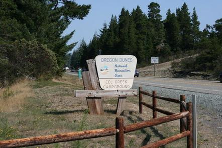
From Reedsport, Oregon travel south 10 miles to the Eel Creek Campground. Campground entrance is located on west side of Highway 101 at mile post 222.

Phone

541-271-6000

Activities

CAMPING, FISHING, HIKING

Keywords

EELC,OREGON DUNES,LAKESIDE OREGON,TUGMAN STATE PARK,SIUSLAW NF – FS

Related Link(s)

Rec Area Info & Images

Oregon State Road Conditions

Oregon State Tourism

Overview

Eel Creek Campground sits among coastal shrubbery on the edge of the sandy dunes of Oregon Dunes National Recreation Area. Eel Creek attracts campers who plan to do more than off-road vehicle riding during their visit to the dunes.

Hikers and birders are attracted to the peaceful atmosphere of the campground. The most popular trail here is the John Dellenback Dunes Trail, which guides hikers through the scenic dunes to the Pacific beach.

The section of dunes in the Umpqua Dune Area features spectacular heights, and the area is one of the easiest locations for pedestrian beach access.

Recreation

The John Dellenback Dunes Trail takes hikers on a 2.7-mile (one way) trek from a conifer forest across the open dunes to the beach on the Pacific Ocean. To private vistas of fresh water lakes like Threemile Lake. The trail finishes at a beach on the Pacific. This hike makes for an incredible workout, due to tall dunes and soft sand. Quality wildlife watching is also a feature of the campground.

Facilities

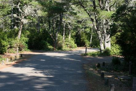
The campground is divided into a North and South Loop. Amenities include flush toilets, drinking water and a self pay station. A campground host is on hand and an amphitheater sits between the two loops. This campground has 51 sites, 38 are reservable and the rest are available on a first-come first-serve basis.

Natural Features

Most sites are secluded and private due to dense shrubbery like rhododendrons and Salal. Sites 7, 8, 42 and 43 are perched on the sand of the dunes. The Oregon Dunes National Recreation Area, in the southern end of Siuslaw National Forest, is known for its wind-sculpted sand dunes towering up to 500 feet above sea level.

Nearby Attractions

Visit Umpqua Lighthouse State Park, along Lake Marie. The Umpqua River Lighthouse stands on the site where the first lighthouse on the Oregon Coast was built in 1857. The current lighthouse dates back to 1890.

Reservation

More from CampingHiking.net:

NANCYTOWN GROUP CAMPGROUND, Georgia Campground Images, Info & Reservations

Listen Directions From Interstate 85 in Georgia, merge onto Interstate 985 via exit 113. Interstate 985 will eventually become State Highways 441/365. Continue north for about 5 miles to Cornelia, then take the Clarkesville/Highway 197 exit and turn right. Turn right again at Dick’s Hill Parkway. Continue approximately a mile

CHRISTIE CAMPGROUND, California Campground Images, Info & Reservations

Listen Directions From Susanville, California, take Highway 36 west for 2 miles to County Road A-1. Turn north and continue 14 miles to the Eagle Lake Recreation Area. Continue past Gallatin Road, the first highway you will come to in the lake basin, and follow the signs to Christie Campground.

WAITSBORO CAMPGROUND, Kentucky Campground Images, Info & Reservations

Listen Directions From Somerset Kentucky, take Highway 27 south for 5 miles. Turn right on Waitsboro Road and follow signs to the campground. Phone 606-561-5513 Activities BOATING, CAMPING, FISHING, DAY USE AREA Keywords WAIT,LAKE CUMBERLAND,WOLF CREEK DAM Related Link(s) Rec Area Info & Images Kentucky State Road Conditions Kentucky State

LOST LAKE CABINS, Wisconsin Campground Images, Info & Reservations

Listen Directions Lost Lake rustic cabins are located about 100 yards South of the Lost Lake Campground off of Forest Service Road 2156! From Florence, take Highway 70 for about 20 miles and take a righ onto Forest Service Road 2450, go about 1 mile and continue straight onto Forest

DENNIS COVE CAMPGROUND, Tennessee Campground Images, Info & Reservations

Listen Directions Take US 321/TN 67 East out of Hampton, TN. Turn right onto Dennis Cove Road and drive approximately 5 miles. Dennis Cove Road is steep with hairpin turns, so plan to drive slowly.  Phone 423-735-1500 Activities CAMPING, FISHING, HIKING, HUNTING, WILDLIFE VIEWING, SWIMMING, MOUNTAIN BIKING, WATER ACCESS, BACKPACKING,

SPRINGY POINT, Idaho Campground Images, Info & Reservations

Listen Directions From Sandpoint, Idaho, take US 95 south across the Long Bridge, then turn west onto Lakeshore Drive. After three miles turn right into the campground. Phone 208-437-3133 Activities BOATING, CAMPING, FISHING, PICNICKING, DAY USE AREA, SWIMMING Keywords SPRP,ALBENI FALLS DAM Related Link(s) Rec Area Info & Images Idaho