DENNIS COVE CAMPGROUND, TN Campground Reservation, Info, Images, Map, Directions

DENNIS COVE CAMPGROUND, Tennessee Campground Images, Info & Reservations

Listen

Directions

Take US 321/TN 67 East out of Hampton, TN. Turn right onto Dennis Cove Road and drive approximately 5 miles. Dennis Cove Road is steep with hairpin turns, so plan to drive slowly. 

Phone

423-735-1500

Activities

CAMPING, FISHING, HIKING, HUNTING, WILDLIFE VIEWING, SWIMMING, MOUNTAIN BIKING, WATER ACCESS, BACKPACKING, EMERGENCY SERVICES

Keywords

Related Link(s)

Rec Area Info & Images

Tennessee State Road Conditions

Tennessee State Tourism

Overview

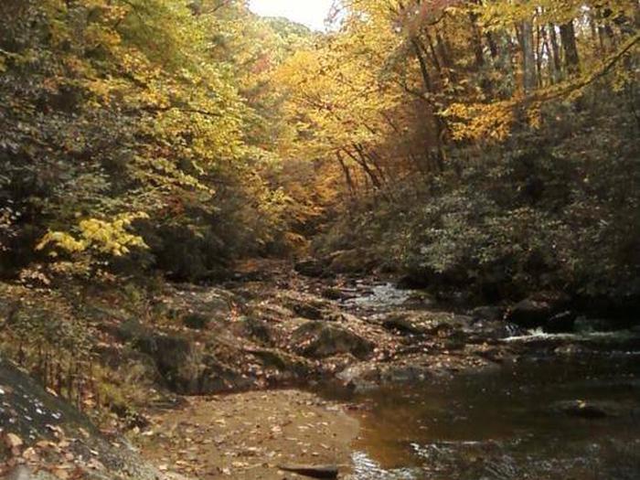
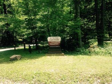
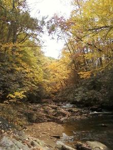
Dennis Cove Campground will close for the season on Monday, October 14, 2019. Dennis Cove Campground is a secluded campground along Laurel Fork Creek at an elevation of 2,650 feet in Carter County. This remote developed campground is popular with those seeking a rustic experience. The altitude, creek side location and lush forest surroundings make Dennis Cove particularly desirable during hot summer months. With 15 campsites, Dennis Cove is a great option for a group to reserve the whole campground for retreats and other events.  

Recreation

Along with camping, Laurel Fork Creek is stocked with rainbow trout below the campground. Above the campground, the creek and its tributaries are managed as wild trout streams for brown, rainbow and brook trout. Laurel Fork Trail (#39) follows the creek upstream for 8.0 miles with twenty-six stream crossings. The Appalachian National Scenic Trail is accessed via the nearby Coon Den Falls Trail (# 37).

Facilities

There are 15 single campsites, including two double sites within Dennis Cove Campground. The campground has flush toilets. Each site contains a table, fire ring and lantern holder.

Natural Features

Dennis Cove Campground is located along the beautiful Laurel Fork Creek nestled in the mountains of the Southern Appalachians.

Nearby Attractions

Trailheads for Coon Den Falls Trail (#37) and the Appalachian National Scenic Trail (#1) are approximately a half mile west of the campground on Dennis Cove Rd. Watauga Lake is approximately 25 minutes away.

Reservation

More from CampingHiking.net:

THIBAUT POINT, Missouri Campground Images, Info & Reservations

Listen Directions From Highway 65, take Highway T west for 3 miles. Turn south on Georgetown Ave and follow for a mile, following signs into the park. Phone 660-428-2470 Activities BOATING, CAMPING, FISHING, FISH HATCHERY, SWIMMING SITE Keywords THIB,TRUMAN LAKE,TEBO,HARRY S TRUMAN Related Link(s) Rec Area Info & Images Missouri

GOOSEBERRY GROUP, Utah Campground Images, Info & Reservations

Listen Directions From Fairview, Utah, travel north about a mile on Highway 89, to the junction with Highway 31. Travel east on Highway 31 for about nine miles, to the junction with Forest Development Road 124. Go north on Forest Development Road 124 for one mile to the campground. Phone

SWEETWATER CG, Georgia Campground Images, Info & Reservations

Listen Directions From I-75 take exit 290 and head east on Highway 20 toward Canton/Rome. After approximately 12 miles turn right onto Fields Chapel Road and follow for 2 miles into the campground. From I-575 take extit 16. Follow Highway 20 west toward Cartersville, after 5 miles turn left on

LeBaron Campground, Utah Campground Images, Info & Reservations

Listen Directions Travel east of Beaver approximately 10 miles on SR 153, turn right on to Forest Road 137 for about 10 miles. Phone 435-438-2436 Activities CAMPING, FISHING, WILDLIFE VIEWING Keywords LEBARON CAMPGROUND,LEBERON,LABARON Related Link(s) Rec Area Info & Images Utah State Road Conditions Utah State Tourism Overview LeBaron Campground

RUSSELL PARK, Texas Campground Images, Info & Reservations

Listen Directions From I-35, take FM 2338 west 7.5 miles to FM 3405, then go south 2 miles to CR 262. Go east 2 miles to the park entrance. Phone 512-930-5253 Activities BOATING, CAMPING, FISHING, HIKING, HUNTING, PICNICKING, WATER SPORTS, WILDLIFE VIEWING, SWIMMING SITE, PADDLING, MOUNTAIN BIKING Keywords Related Link(s)