MARION LAKE GROUP SITE, MI Campground Reservation, Info, Images, Map, Directions

MARION LAKE GROUP SITE, Michigan Campground Images, Info & Reservations

Directions

Marion Lake Group Camping site is accessed most easily from U.S. Highway 2. Turn north from US-2 onto Marion Lake Road, also known as Forest Road 3980. Travel approximately 1.5 miles north and then turn right onto Forest Road 3985. Travel until road makes a Y, where a location map is located there to show you the layout of the campground.

Phone

906-358-4724

Activities

BIKING, BOATING, CAMPING, FISHING, WATER SPORTS, WILDLIFE VIEWING, SWIMMING, BIRDING

Keywords

MLGS,Marion Lake Group Site,Marion Lake

Related Link(s)

Rec Area Info & Images

Michigan State Tourism

Michigan State Road Conditions

Overview

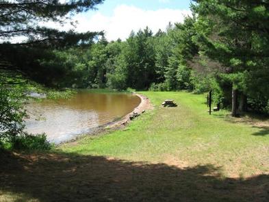
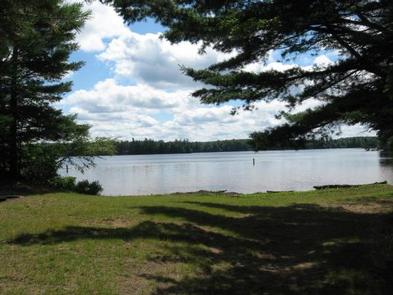
The sparkling Marion Lake offers breathtaking and exciting camping for your next family trip. Live it up on the water with your jet skis or wake board, or tone down the pace with a full day of fishing. The Marion Lake Group Site is an ideal way to spend time with friends and family for all the water activities you can imagine. Marion Lake is in the Ottawa National Forest, a protected area in the Western Upper Peninsula of Michigan. It stretches from the Lake Superior shoreline to the Wisconsin border, and attracts deer and many types of migrating birds.

Recreation

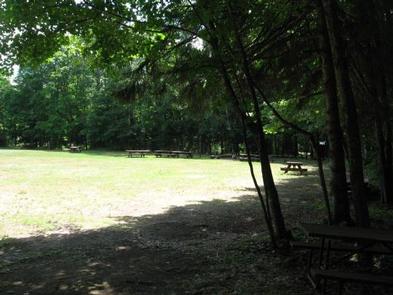
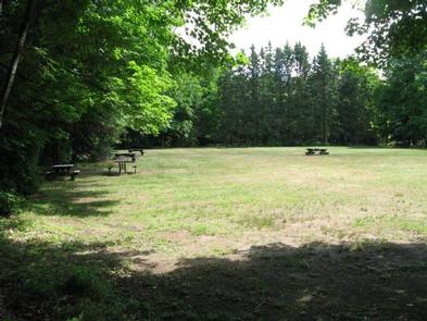
A swim beach is adjacent to the group site.

Facilities

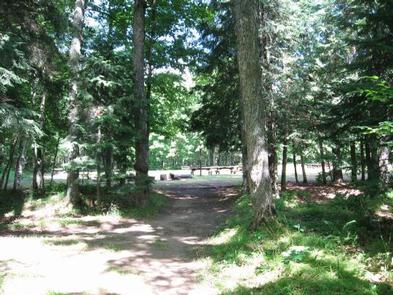
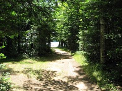
A convenient path leads to the lake and boat launch. Water is not available on-site, but is a short walk away.

Natural Features

The campground is in a large, grassy field surrounded by hemlock and hardwood trees with an opening to Marion Lake. The altitude is 1,627 feet, with lightly rolling hills stretched between the many other lakes in the area.

Nearby Attractions

Hiking enthusiasts will find scenic trails throughout the Sylvania Wilderness area, a region to the west with old-growth forests and 34 named lakes. On the way, stop by the Ottawa Visitor Center in Watersmeet for some interesting exhibits.

Reservation

More from CampingHiking.net:

SOUTH MANITOU GROUP, Michigan Campground Images, Info & Reservations

Directions From Traverse City, Michigan, take M-22 to Sutton’s Bay. Go west on M-204 from Sutton’s Bay towards Leland. Turn north at the junction of M-22 and M-204 to Leland. Take the ferry from Leland to South Manitou Island. Phone 231-326-4700 Activities CAMPING, HIKING, VISITOR CENTER Keywords CG55,Bay,South Manitou Island,Weather

MOUNT ROSE (NV), California Campground Images, Info & Reservations

Directions From Highway 395 south of Reno, travel 17 miles west on State Route 431, following signs to the campground. The Actual Mailing Address is: PO Box 104, Markleeville, CA 96120. The Physical Address is: Mt. Rose Hwy, State Route 431, Reno, NV 89511. Phone 530-694-1002 Activities BIKING, CLIMBING, CAMPING,

LAKE THREE, Wisconsin Campground Images, Info & Reservations

Directions 34412 Mineral Lake Rd. (FR 198) From Mellen, Wisconsin; Take County Highway GG west for about 8 miles. Turn right onto Forest Service Road 187/Mineral Lake Road and continue for 3 miles to the intersection with Forest Service Road 198/Pine Stump Corner. Turn right and continue less than a

BAXTER, Missouri Campground Images, Info & Reservations

Directions From Lampe, Missouri, continue onto Highway 13 and turn west onto Highway H. Continue nearly 5 miles to the campground. Phone 417-779-5370 Activities BIKING, BOATING, CAMPING, FISHING, HIKING, PICNICKING, WATER SPORTS, DAY USE AREA, SWIMMING SITE, PHOTOGRAPHY, SWIMMING, MOTOR BOAT, RANGER STATION, WATER ACTIVITIES, KAYAKING, STAR GAZING, BIRDING, WATER