Directions
The cabin is located approximately 16 miles east of the town of Tusayan, Arizona on a graded gravel road. From Highway 64/180, turn east onto Forest Road 302 just south of the Grand Hotel in Tusayan. Turn left at the junction of Forest Roads 302 and 310. Follow Forest Road 310 for 1.5 miles and turn right on Forest Road 307. Follow the signs to Hull Cabin, which is just over a mile further.
From State Highway 64 at the South Rim entrance station of Grand Canyon National Park (requires an additional entrance fee to the park), drive north for 4 miles. Turn right, staying on Highway 64, and continue east for approximately 8.7 miles, past a left turn sign for Grandview Point. Continue driving east on Highway 64 for 2 more miles (for a total of 10.7 miles after 64 turns east at the canyon rim). After mile marker 253, there is a sign that indicates a right turn onto a National Park Service gravel road. Follow this road (which becomes Forest Road 310) for 1.5 miles to Forest Road 307. Take a left and follow the signs to Hull Cabin, approximately 1.5 miles.
Phone
928-638-8217 (8-4:30 M-F)
Activities
BIKING, HISTORIC & CULTURAL SITE, CAMPING, HIKING, WILDLIFE VIEWING, FIRE LOOKOUTS/CABINS OVERNIGHT
Keywords
Hull Cabin,Hull Cabin Historic Site,Hull Cabin Historic District
Related Link(s)
Overview
Located just steps away from the world-famous Grand Canyon National Park, Hull Cabin is the oldest historic structure in the area. It provides a variety of amenities, as well as access to multiple recreational activities within the Tusayan Ranger District of the Kaibab National Forest. Visitors enjoy miles of trails, fishing at the nearby tanks, sightseeing and viewing the region’s abundant wildlife.
The cabin can be accessed by vehicle. A portion of the roadway is graded gravel, requiring slower speeds. Guests are responsible for their own travel arrangements and safety, and must bring several of their own amenities.
Recreation
With miles upon miles of national forest and park lands to explore, visitors have no shortage of outdoor activities from which to choose. Hiking, horseback riding and mountain biking are available on an 800-mile segment of the Arizona Trail, as well as within Grand Canyon National Park.
Fishing can usually be accessed at nearby Russell Tank during an average or high water season. The small Hull Tank, located near the cabin, is a prime watering hole for wildlife such as elk, mule deer, wild turkey, javelina and numerous birds and raptors. Lucky visitors may even have the chance to spot an endangered California condor.
Facilities
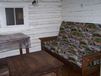
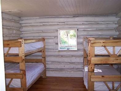
The cabin sleeps up to six people. It consists of a bedroom, living room and a fully equipped kitchen. The bedroom has two sets of twin-sized bunk beds, and there is one queen-sized futon in the living room. Kitchen supplies include indoor plumbing (water is hauled to the site), an oven, stove, refrigerator with freezer, dishes, utensils, pots, pans and some cleaning supplies.
A separate shower house is located just outside the cabin and contains a vault toilet and two shower stalls with solar shower attachments (click here for more cabin details).
Guests must bring their own food, bedding (sheets, blankets, pillows and/or sleeping bags), towels for the bathroom and kitchen, garbage bags, warm clothing, dish soap, flashlights and an axe for splitting wood for the outdoor fire pit. Visitors must bring their own solar-shower bladder bags for use of the outdoor shower.
Natural Features
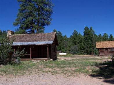
The cabin sits in a secluded meadow surrounded by a stand of old growth ponderosa pine trees, at an elevation of 6,500 feet. The location provides easy access to Grandview Lookout Tower, which offers 360-degree views of the canyon and surrounding forest.
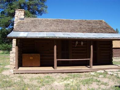
The building originated as a one-room homestead, constructed by the Hull family in the late 1880s with hand-hewn logs. It was acquired by the U.S. Forest Service in 1907 for use as a ranger station. In 1985, the cabin was listed in the National Register of Historic Places. Summer temperatures on the South Rim are relatively pleasant, but weather can be unpredictable. Visitors should come prepared for changeable mountain weather, cold nights, thunderstorms or even snow.
Nearby Attractions
Grand Canyon National Park’s South Rim is a must-see for visitors and is located just a mile away. The South Rim is the most accessible part of the park and is open all year. The nearby town of Tusayan also offers restaurants, hotels, gift shops, a general store and various tours.


