


Directions
Access to the lookout is by a dirt road; high clearance vehicles are recommended. Visitors should be aware that access is subject to inclement weather during the early and late season.
Black Mountain Lookout is located on the eastern edge of the Beckwourth Ranger District, 10 miles from Highway 395, near Milford, California.
From Highway 395 at Milford take County Road 336 to Milford Grade. Turn right onto Milford Grade (also named County Road 336 and Forest Rd. 26N70. Turn left on Forest Road 26N80 and continue on this road to lookout.
Phone
(530) 836-2575
Activities
CAMPING, INTERPRETIVE PROGRAMS, HIKING, WILDLIFE VIEWING
Keywords
Black Mountain,Black Mountain Lookout
Related Link(s)
California State Road Conditions
Overview
This facility has been closed for the 2019 season. This is due to the Walker Fire.
Black Mountain Lookout is located on the eastern edge of the Beckwourth Ranger District, 10 miles from Highway 395, near Milford, California.
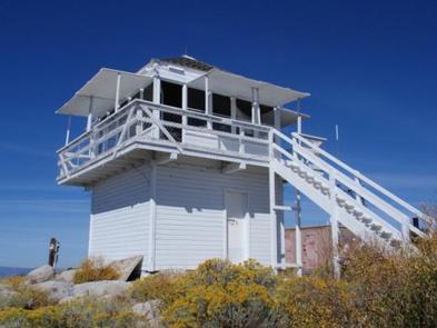
The lookout was constructed in 1934 and is a great example of Civilian Conservation Corps (CCC) architecture. The C-3-type lookout is situated on a single story 10 foot tower and is extremely well-preserved.
The lookout tower is available for Memorial Day weekend through October, offering guests a unique lodging experience in Plumas National Forest.
Recreation
Hiking, birding, stargazing and wildlife viewing are popular among guests of the lookout. On a clear night, visitors can gaze upon the expansive sky as it unfolds with a dazzling display of stars.
Facilities
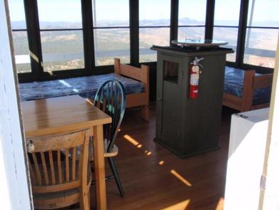
The one-room lookout cabin is set on a tower, rising 10 feet above the ground. It is furnished with two single beds with mattresses, but can accommodate up to four people. There is also space for tent camping adjacent to the lookout, for up to four visitors.
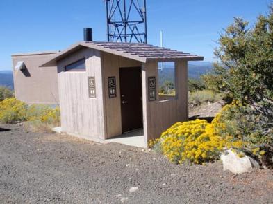
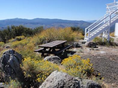
The cabin has a small table and chairs, a refrigerator, a small stove, heater, and lights, all powered with electricity. A picnic table and vault toilet are also on site.
Although the lookout provides a few amenities, guests must bring several of their own, including food, cooking utensils, sleeping bags, towels, dish soap and garbage bags.
No water is available at this facility, so guests must bring their own water for drinking, cooking and washing. Packing an additional light source is also recommended.
Natural Features
The Plumas National Forest is defined by its unique land features and pleasant climate. Outdoor enthusiasts are attracted to the many streams and lakes, beautiful deep canyons, rich mountain valleys, meadows and lofty peaks.
Guests at Black Mountain Lookout are treated to striking views of Honey Lake to the north, and Last Chance Creek to the south.
Diverse vegetation provides a habitat for wildlife including deer, coyotes, bald eagles and osprey.
Frenchman Lake is within a 30-minute drive from the lookout. This lake is popular for swimming, water skiing, fishing and camping.