DENBY POINT, AR Campground Reservation, Info, Images, Map, Directions

DENBY POINT, Arkansas Campground Images, Info & Reservations

Directions

From Hot Springs, Arkansas, take US 270 west about 26.5 miles to Ouachita Shores Parkway. Turn right and follow access road one mile north to park. From Mount Ida, Arkansas, take US 270 east approximately 9.5 miles to Ouachita Shores Parkway. Turn left on access road one mile to park.

Phone

870-867-4475

Activities

BOATING, CAMPING, WATER ACTIVITIES, KAYAKING, CANOEING

Keywords

DENB,LAKE OUACHITA,DENBY,OUACHITA SHORES,LAKE OUACHITA

Related Link(s)

Rec Area Info & Images

Arkansas State Tourism

Arkansas State Road Conditions

Overview

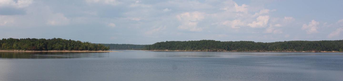
Groups and families of all sizes come to camp at Denby Point for its scenic views, year-round fishing and convenient boating facilities. The campground promises to entertain jet skiers, boaters, hikers and birders alike.

Click here for the Lake Ouachita Virtual Tour.

Recreation

World-class striper fishing brings crowds of anglers year-round, and incredibly clear waters attract scuba divers, hoping to explore the flooded forests and mountain valleys below the lake’s surface. Hikers take pleasure in the Lake Ouachita Vista Trail (LOViT), which lines the southern end of the lake.

Facilities

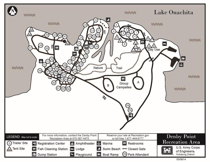
The campground consists of 67 sites including 58 with electric and water hookups. The two group campsites also have electric hookups. Other amenities include a dump station, fish cleaning station, hot showers, boat ramp and a swim beach.

Natural Features

Lake Ouachita sits in the heart of the Ouachita Mountains, just 28 miles west of Hot Springs National Park. The lake stems from the Ouachita River and boasts 692 miles of shoreline and over 40,000 surface acres.

Nearby Attractions

Explore Ouachita National Forest’s 1.8 million acres, surrounding Lake Ouachita and extending across central Arkansas and southeastern Oklahoma.

Reservation

More from CampingHiking.net:

BIG ELK GUARD STATION, Oregon Campground Images, Info & Reservations

Directions Drive east from Butte Falls on the Butte Falls-Fish Lake Highway (County Road #821) for approximately 19 miles to the junction with State Highway #140. Turn right, go .08 miles on Highway #140 to the junction with Forest Service Road #37. Turn left, and travel approximately 4 miles to

BASIN MONTANA CAMPGROUND, Montana Campground Images, Info & Reservations

Directions From US Hwy 212 (Beartooth Scenic Byway), travel to the south end of Red Lodge, MT. Turn west on West Fork Rock Creek Road (Forest Road 2071), and proceed approximately 7 miles to the campground entrance on the right. Phone 406-587-9054 Activities BIKING, FISHING, HIKING Keywords BASIN MONTANA CAMPGROUND,BASM,CUSTER

Moonflower Canyon Group Site, Utah Campground Images, Info & Reservations

Directions From the center of Moab (at Center and Main) head south to Kane Creek Road. Turn right (west) on Kane Creek Road and drive 3.5 miles. You will see the Moonflower Campground on the left just past the King’s Bottom Campground. Phone (435)259-2100 Activities BIKING, HISTORIC & CULTURAL SITE,

CHEOAH POINT CABIN 2, North Carolina Campground Images, Info & Reservations

Directions From Robbinsville, North Carolina, continue on Highway 129 north for approximately 6 miles. Turn left on SR # 1145 – Thunderbird Mountain Road. Continue approximately 1.3 miles on Thunderbird Mountain Road to the Cheoah Point Campground. The cabin is located in the Cheoah Point Campground. Phone 828-479-6431 Activities BOATING,

RIPPLEBROOK, Oregon Campground Images, Info & Reservations

Directions From Estacada, travel east on Highway 224 for 26 miles to the campground, which is just past the Ripplebrook Camp Store. Phone 503-630-5721 Activities CAMPING, FISHING, WATER SPORTS Keywords RIPP,MT. HOOD NF – FS Related Link(s) Rec Area Info & Images Oregon State Tourism Forest Service Concessionaire Oregon State

BIG MEADOWS, Virginia Campground Images, Info & Reservations

Directions From Washington, D.C., metro area, travel west on Interstate 66 to exit 43A. Take US Highway 29 south to Warrenton, Virginia, then merge onto US Highway 211 west to Shenandoah National Park and Skyline Drive Thornton Gap Entrance. Take Skyline Drive south approximately 19 miles and turn right into