JOPLIN, AR Campground Reservation, Info, Images, Map, Directions

JOPLIN, Arkansas Campground Images, Info & Reservations

Directions

From Hot Springs, Arkansas: Take US 270 west for 23.5 miles to Mountain Harbor Road. Turn right and follow access road three miles north to the park.

Phone

870-867-4472

Activities

BIKING, BOATING, CAMPING, FISHING, WATER ACTIVITIES, KAYAKING, CANOEING

Keywords

JOPL,LAKE OUACHITA,MOUNTAIN HARBOR,LAKE OUACHITA

Related Link(s)

Rec Area Info & Images

Arkansas State Tourism

Arkansas State Road Conditions

Overview

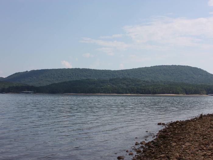
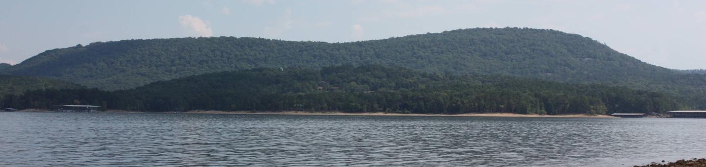
Joplin Campground on Lake Ouachita is an excellent destination for pristine lakefront camping. Joplin is perched on a slender peninsula with plenty of attractive scenic views of the water and surrounding mountain terrain.

World-class striper fishing goes on in the lake, and wildlife watchers can find everything from bobcats to rare freshwater jellyfish.

Click here for the Lake Ouachita Virtual Tour.

Recreation

Prized as one of the clearest lakes in the nation, Ouachita Lake is ideal for scuba diving.

Visitors also enjoy hiking, biking, scenic driving, water skiing, fishing and hunting, as well.

Facilities

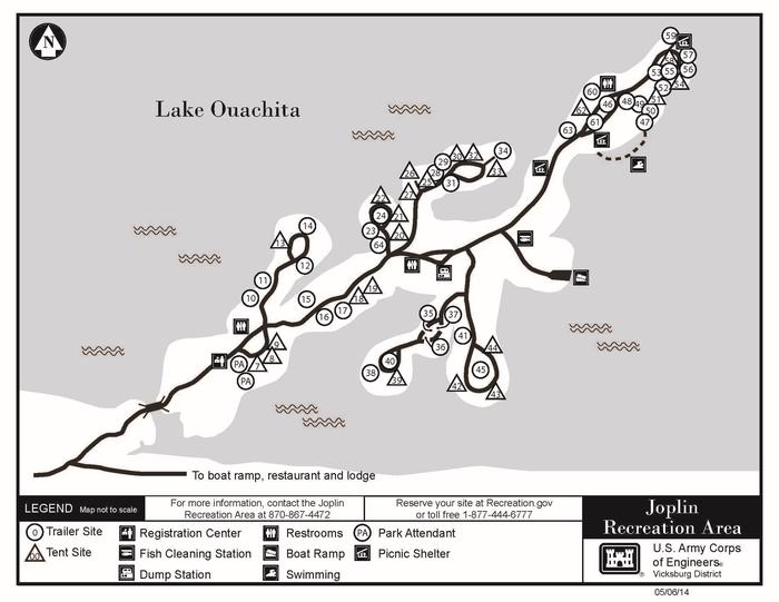
All 59 campsites have electric hookups, but keep in mind the spaces are small and unpaved. Campsite pad lengths vary greatly from site to site due to the terrain. No campsite lengths are posted on the website due to the varianciances of camper slidout configurations and the visitor trailer towing skills. For questions contact the fee booth at 870-867-4472. Water hookups are not available, but a water faucet is located in each loop. Other amenities include a dump station, fish cleaning station, hot showers, boat ramp and a swim beach.

Natural Features

Nestled in the Ouachita Mountains of Central Arkansas, Lake Ouachita spans a surface area of over 40,000 acres, making it the biggest lake completely within the state of Arkansas. The region has a climate with four seasons. Spring and fall are mild, summer is hot and humid, and winter is variable with temperatures ranging from below freezing on up to the 60 degrees Fahrenheit.

Nearby Attractions

Head to Hot Springs National Park and discover how it earned the nickname, “The American Spa.” Or take a scenic drive through the 1.8 million-acres of Ouachita National Forest. Boat rentals, horseback riding rentals and the Hickorynut Mountain Vista are not far from the campground.

Reservation

More from CampingHiking.net:

Dam Site Shelter, North Carolina Campground Images, Info & Reservations

Directions From Charlotte, North Carolina, take I-77 North (approximately 60 miles) before merging onto Highway 421 North towards Wilkesboro/Boone. Continue to Exit 286B (approximately 20 miles), turn left onto Highway 268, continue for approximately 4 miles and turn right on Reservoir Road. Turn left into the Visitor Assistance Center parking

ASPEN GROUP AREA, New Mexico Campground Images, Info & Reservations

Directions In southeast New Mexico, approximately 20 miles east of Alamagordo. From Alamagordo take US 82 east and go 16 miles. Just before Cloudcraft turn right (South) on NM 130. Go 1.4 miles. Turn left (east) on Forest Road 24B, go 0.5 miles. Aspen Group Area is on the left

BOCA SPRING, California Campground Images, Info & Reservations

Directions From Reno, take I-80 west to Hirschdale Exit. Go north approximately 3 miles then turn right and go 1 mile to the campground. From Truckee, take I-80 east to Hirschdale exit. Turn left and travel approximately 3 miles then turn right and go 1 mile to the campground. Phone

SANTA ROSA ISLAND, California Campground Images, Info & Reservations

Directions Boat transportation can be arranged with Island Packers from Ventura Harbor. Air transportation can be arranged with Channel Islands Aviation from Camarillo airport. To park headquarters in Ventura, California: Highway 101, exit Victoria or Seaward to Ventura Harbor. Phone 805-658-5730 Activities BOATING, HISTORIC & CULTURAL SITE, CAMPING, INTERPRETIVE PROGRAMS,

LANGOHR CAMPGROUND, Montana Campground Images, Info & Reservations

Directions From Main Street in Bozeman, travel south along 19th Avenue for 7 miles, to the paved Hyalite Canyon Road. Turn left and continue south for about 5 miles, to the campground. Phone (406)646-1012 Activities BIKING, CAMPING, FISHING, HIKING, WILDLIFE VIEWING, PHOTOGRAPHY, MOUNTAIN BIKING, STAR GAZING, BIRDING, WATER ACCESS, BACKPACKING

RENEGADE, Utah Campground Images, Info & Reservations

Directions From Heber City, Utah, take Highway 40 east for 28 miles to Strawberry Bay Junction. Turn right and travel 12 miles to campground. Phone HEBER RANGER DISTRICT 435-654-0470 OR UTAH RECREATION COMPANY 385-273-1100 Activities BIKING, BOATING, CAMPING, FISHING, HIKING, WATER ACTIVITIES Keywords RENG,UINTA NF – FS Related Link(s) Rec