SPIRE ROCK CAMPGROUND, MONTANA Campground Reservation, Info, Images, Map, Directions

SPIRE ROCK CAMPGROUND, Montana Campground Images, Info & Reservations

Directions

From Bozeman, travel south on Highway 191 for 23 miles to the Storm Castle turnoff. Turn left and go 3 miles to the campground. The last 3 miles are on a gravel road.

From West Yellowstone, go 66 miles north on Highway 191 to the Storm Castle turnoff. Turn right at the intersection after the bridge and continue 3 miles to the campground.

Phone

406-646-1012

Activities

BIKING, CAMPING, FISHING, HIKING, WILDLIFE VIEWING, PHOTOGRAPHY, MOUNTAIN BIKING, BERRY PICKING, STAR GAZING, BIRDING, BACKPACKING, MUSHROOM PICKING

Keywords

SPIR,Squaw Creek Campground,GALLATIN NF – FS

Related Link(s)

Rec Area Info & Images

Montana State Road Conditions

Montana State Tourism

Forest Service Concessionaire

Overview

Spire Rock Campground is located in scenic Gallatin Canyon on the Bozeman Ranger District of the Gallatin National Forest, in southwestern Montana. It is 26 miles south of Bozeman.

The surrounding area offers many outdoor recreational opportunities, including fishing, rafting, hiking and viewing local wildlife.

Recreation

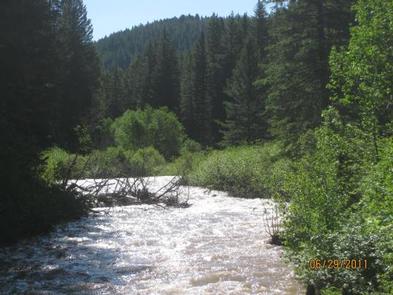
Great opportunities for hiking, fishing, scenic driving and wildlife viewing are available around the campground. Anglers cast for rainbow, brown, brook and cutthroat trout, whitefish and Arctic grayling on the Gallatin River. Rafting and kayaking are popular activities as well.

The popular Storm Castle Trail begins nearby. This steep, 3-mile one-way trail climbs to Storm Castle Rock, with excellent views of the canyon below. Garnet Mountain Lookout Trail also begins near the campground. The 3.5-mile trail climbs 2,800 feet in elevation, to the lookout.

Facilities

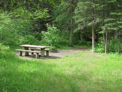
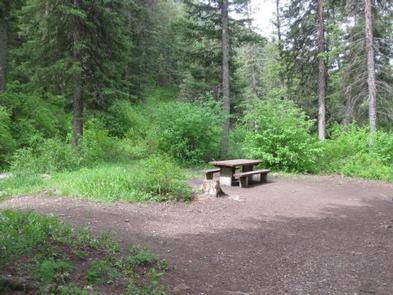
The campground offers single-family campsites, an overnight, GROUP CAMPING AREA (SITE 2), and another GROUP AREA (SITE 12), that can be used for overnight camping or day-use picnicking. Picnic tables and campfire rings are provided, as are vault toilets.

No drinking water is available in the campground. Campers must bring their own water. Roads and parking spurs within the campground are gravel.

Natural Features

The campground sits next to Storm Castle Creek, a tributary of the Gallatin River, at an elevation of 5,600 feet. Most campsites are located along the creek and are surrounded by spruce and fir trees.

A variety of wildlife makes its home in the area. Visitors can often glimpse bald eagles, bighorn sheep, moose, elk, mountain goats, deer and coyotes. Black bears and grizzly bears also live in the canyon.

Reservation

More from CampingHiking.net:

CASS LAKE LOOP, Minnesota Campground Images, Info & Reservations

Directions Follow U.S. Highway 2 east of the city of Cass Lake for 4 miles to the entrance of Norway Beach Recreation Area. Phone 218-835-4291 Activities BIKING, BOATING, CAMPING, FISHING, HIKING, WATER SPORTS, WILDLIFE VIEWING, SWIMMING SITE Keywords Cass Lake Campground,Annex Campground Related Link(s) Rec Area Info & Images Minnesota

STEVENS CREEK CAMPGROUND, Colorado Campground Images, Info & Reservations

Directions Stevens Creek campground is located off of US Hwy 50, 12 miles west of Gunnison, CO. Phone 970-641-2337 Activities BOATING, CAMPING, FISHING, HIKING, HUNTING, WATER SPORTS, WILDLIFE VIEWING, SWIMMING SITE Keywords STEC,CURECANTI NATIONAL RECREATION,CURECANTI,STEVENS Related Link(s) Rec Area Info & Images Colorado State Tourism Colorado State Road Conditions Overview

LITTLE CRATER CAMPGROUND, Oregon Campground Images, Info & Reservations

Directions From Bend, travel 23.5 miles south on Hwy 97, then 14.5 miles east on Road 21, and 0.5 miles north on Forest Road 2100 570. Phone 541-383-5300 Activities CAMPING Keywords Related Link(s) Rec Area Info & Images Oregon State Road Conditions Oregon State Tourism Overview Situated on the edge

CRANDALL CREEK CABIN, Montana Campground Images, Info & Reservations

Directions Crandall Creek Cabin is located approximately 24 miles northeast of Wilsall, and 52 miles from Livingston. From Livingston, travel north on Highway 89 to Wilsall. Turn right from Highway 89 onto Shields River Road. Follow Shields River Road until the pavement ends and turn right at the end of

Sentinel Campground, California Campground Images, Info & Reservations

Directions From Fresno, CA, follow California State Highway 180 East to Cedar Grove. Sentinel Campground is located on the left (north) side of the road in the village. Phone (559) 565-3341 Activities CAMPING, INTERPRETIVE PROGRAMS, HIKING, HORSEBACK RIDING, VISITOR CENTER, DAY USE AREA Keywords Related Link(s) Rec Area Info &