EASTWOOD, WI Campground Reservation, Info, Images, Map, Directions

EASTWOOD, Wisconsin Campground Images, Info & Reservations

Listen

Directions

From Medford, Wisconsin, travel north on State Highway 13 for about 15 miles. Turn left on County Road D for about 6 miles, then turn left onto Forest Road 104 for about 2 miles and continue into the campground.

Phone

715-748-4875

Activities

BOATING, CAMPING, FISHING, HIKING, WILDLIFE VIEWING, SWIMMING SITE, OTHER RECREATION CONCESSION SITE

Keywords

EAST,CHEQUAMEGON-NICOLET NF – FS

Related Link(s)

Rec Area Info & Images

Wisconsin State Tourism

Wisconsin State Road Conditions
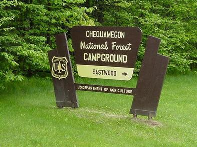
Overview

The Eastwood Campground is a family-friendly campground with access to a beautiful northern Wisconsin recreation area, complete with hiking trails and a scenic lake.

Recreation

A boat ramp into the 411-acre Mondeaux Flowage is available not far from the campground. The lake, although rather shallow, is popular for swimming and fishing. Anglers can expect a catch of musky, pan fish, largemouth bass and pike, among other varieties.

A series of hiking trails is available in the area, including for the 1,200-mile Ice Age National Scenic Trail, which traces the edges of a historic glacier that once covered the state of Wisconsin and much of North America.
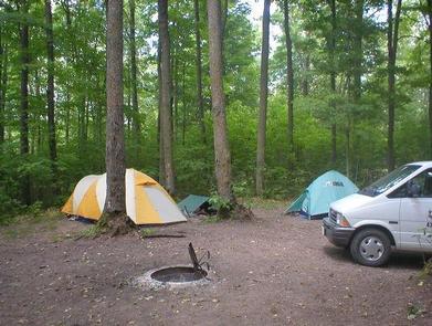
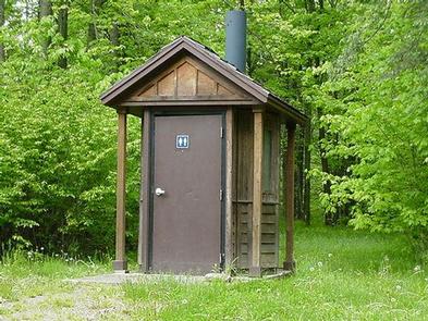
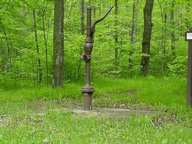
Facilities

The campground offers almost two dozen sites for tent or RV camping. No hookups are available. Each site is equipped with tables and campfire rings with grills. Accessible vault toilets and hand-pump drinking water system are provided. A picnic area, along with concessions and other amenities, is available at the nearby Mondeaux Picnic Area.

Natural Features

The campground sits within the Chequamegon-Nicolet National Forest, near the city of Medford. Shady sites are nestled along the scenic shore of the Mondeaux Flowage, with the Ice Age National Scenic Trail traversing the campground.

Nearby Attractions

The campground is just a couple miles from the popular Mondeaux Picnic Area at the Mondeaux Dam Recreation Area.

Reservation

More from CampingHiking.net:

KAH SHEETS LAKE CABIN, Alaska Campground Images, Info & Reservations

Listen Directions Access by float plane is 22 miles from Petersburg, while access by by boat and hiking trail combination is 24 miles from Petersburg, then a 2.75-mile hike from the bay to the inland lake. A 18-foot tide is required for direct boat access to the trailhead. Please check

GRANITE BUTTE LOOKOUT, Montana Campground Images, Info & Reservations

Listen Directions The lookout is located approximately 16 miles southeast of Lincoln. It can be reached via Stemple Pass Road #601, which leaves downtown Lincoln at the blinking light and joins Highway 279 north of Helena. Follow Stemple Pass Road for approximately 14 miles to the top of the pass

WELDON ISLAND, Georgia Campground Images, Info & Reservations

Listen Directions From Interstate 85, take Exit 4 and turn East onto Old Dobbins Bridge Road.Turn right on Andersonville Road and follow the brown directional signs. Hattons Ford ramp is located at the end of Andersonville Road. Townville, SC, 29689 Phone 888-893-0678 HARTWELL PROJECT OFFICE Activities BOATING, FISHING, PICNICKING, SWIMMING,

CANNING CREEK, Kansas Campground Images, Info & Reservations

Listen Directions From I-70, take Highway 177 south for 30 miles. Turn west across Dam Road, then turn right on to City Lake Road and continue for 2 miles. Campground entrance road is on the right. Phone 620-767-5195 Activities BOATING, CAMPING, FISHING, HIKING, HUNTING Keywords CANK,COUNCIL GROVE,COUNCIL GROVE LAKE Related

POTATO PATCH CAMPGROUND, Arizona Campground Images, Info & Reservations

Listen Directions From Prescott, take U.S. Highway 89 north past Granite Dells, turn right on Hwy 89A and travel approximately 20 miles to the top of Mingus Mountain on steep, mountainous grade. Potato Patch Campground entrance will be to your left (across from the Summit Picnic Area) on Forest Road