DAM WEST DAY USE, IL Campground Reservation, Info, Images, Map, Directions

DAM WEST DAY USE, Illinois Campground Images, Info & Reservations

Directions

From I-70, take State Route 127 south to Carlyle and turn east on Williams Road/1840 E. Williams Road will turn into Lake Road/1430 N. Continue on Lake Road south to the day use area, located on the left.

Phone

618-594-5253

Activities

BIKING, BOATING, CAMPING, INTERPRETIVE PROGRAMS, FISHING, HIKING, HUNTING, WATER SPORTS, WILDLIFE VIEWING, SWIMMING SITE

Keywords

DWDU,DAM WEST,DAM WEST DAY USE CARLYLE LK,CARLYLE LAKE

Related Link(s)

Rec Area Info & Images

Illinois State Road Conditions

Illinois State Tourism

Overview

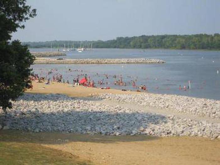
Dam West Day Use Area is situated on the southern shore of Carlyle Lake, a prime getaway for city-dwellers and families. Located 50 miles east of St. Louis, the area offers the peaceful retreat of a small town combined with the grandeur of Illinois’ largest man-made lake.

Recreation

The area provides fun both on the water and on shore. Boat ramps and courtesy docks are provided, and the vast lake allows for plenty of water sports.

Fishing is a popular pastime, and white bass, bluegill, crappie, channel catfish, largemouth bass, freshwater drum, carp, flathead catfish and walleye can be found in abundance.

There is an on-site playground and plenty of open space for children to play in, as well as an amphitheater for educational programs. A multi-use biking and walking trail is located a short drive away at the dam.

Facilities

The day use area has two reservable picnic shelters that can accommodate up to 75 people each, as well as a boat ramp and fish cleaning stations. The facility has access to a marina and boat storage facility. Camping is available at the adjacent Dam West Campground. Visitors can walk or bike across the dam to the Dam East facilities and McNair Group Area.

Natural Features

Created in 1967, the 26,000-acre lake is recognized as one of the nation’s top ten inland sailing lakes and hosts several annual races and regattas.

Carlyle Lake is home to an array of wildlife that can be seen throughout the year. Its waters and shores are a resting spot for migratory waterfowl and other birds. There are six established Watchable Wildlife Sites with viewing towers open to the public around the lake.

Nearby Attractions

Carlyle Lake Visitor Center, located in the Dam West Recreation Area, has information, a gift shop and nature exhibits, including a 215-gallon aquarium with native fish and a display featuring a live massasauga rattlesnake.

Reservation

More from CampingHiking.net:

NAT CALDWELL PARK, Tennessee Campground Images, Info & Reservations

Directions From Nashville, take I-65 North to TN-386/Vietnam Veterans Blvd. Continue East on TN-386/Vietnam Veterans Boulevard to exit 9. Merge onto US-31E N/Johnny Cash Pkwy/E Main St. and continue approximately 2.5 miles. Nat Caldwell Park will be on your left just before crossing over Station Camp Creek. Phone (615) 822-4846

SOUTH OVERLOOK (IA), Iowa Campground Images, Info & Reservations

Directions 1105 North HWY T15 Knoxville, Iowa 50138 From Pella, Iowa, follow county road T-15 southwest for 4 miles, then follow signs to South Overlook. Phone 641-828-7522 Activities BIKING, BOATING, CAMPING, HUNTING, WILDLIFE VIEWING Keywords Related Link(s) Rec Area Info & Images Iowa State Road Conditions Iowa State Tourism Overview

SOUTH MARCUM CAMPROUND, Illinois Campground Images, Info & Reservations

Directions From I-57 take exit 71 and turn west onto Highway 14. After 3 miles turn right on Rend City Road, then right on Rend Lake Dam Rd. Continue 3 miles to the park entrance on the left. Phone 618-724-2493 Activities BIKING, BOATING, CAMPING, FISHING, HIKING, HUNTING, SWIMMING SITE Keywords

COOKSON BEND, Oklahoma Campground Images, Info & Reservations

Directions From Tahlequah, OK go 17.5 miles southeast on Highway 82. Look for sings for Tenkiller and turn right, then go two miles west on the paved access road. Phone 918-487-5252 Activities BOATING, CAMPING, SWIMMING SITE Keywords COBE,TENKILLER LAKE,TENKILLER FERRY LAKE,TENKILLER FERRY Related Link(s) Rec Area Info & Images Oklahoma

EAGLE CABIN, Alaska Campground Images, Info & Reservations

Directions The cabin is located 8 air miles east of Yakutat on the east bank of Situk River. Access is by trail, boat or wheeled aircraft. From Nine Mile Bridge on Forest Highway 10, hike the 3-mile trail or boat 3.2 miles downriver (1.5 hour float). The cabin 9.6 miles

CASTLE ROCK GROUP CAMPGROUND, Oregon Campground Images, Info & Reservations

Directions From Hebo, Oregon travel south on Highway 22, 4.2 miles. Location is on the right. Phone 503-392-5100 Activities HIKING, SWIMMING Keywords Related Link(s) Rec Area Info & Images Oregon State Tourism Oregon State Road Conditions Overview Located on Three Rivers, this group campground is ideal for family gatherings and