MONTPELIER CANYON CAMPGROUND, ID Campground Reservation, Info, Images, Map, Directions

MONTPELIER CANYON CAMPGROUND, Idaho Campground Images, Info & Reservations

Directions

The campground is located three miles east of Montpelier, Idaho, on U.S. Highway 89.

Phone

541-351-1182

Activities

BIKING, BOATING, CAMPING, FISHING, HIKING, HORSEBACK RIDING, WILDLIFE VIEWING

Keywords

MTPC,MONTPELIER CAMPGROUND,CARIBOU-TARGHEE NF – FS

Related Link(s)

Rec Area Info & Images

Idaho State Road Conditions

Idaho State Tourism

Overview

Montpelier Canyon Campground provides a rustic camping opportunity next to Highway 89, along Montpelier Creek, at an elevation of 6,400 feet. Montpelier Reservoir is within five miles, offering fishing, boating and canoeing.

Recreation

Montpelier Creek offers rainbow, cutthroat and brown trout fishing. Many visitors make the short drive to Montpelier Reservoir for boating, canoeing and additional fishing opportunities. A boat ramp is located at the reservoir.

Facilities

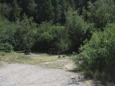
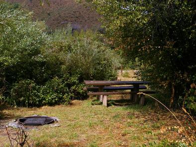
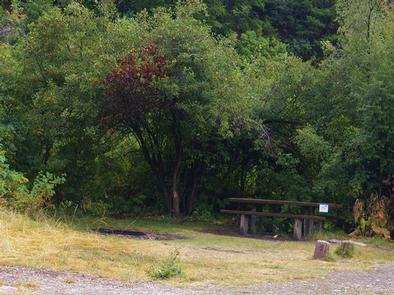
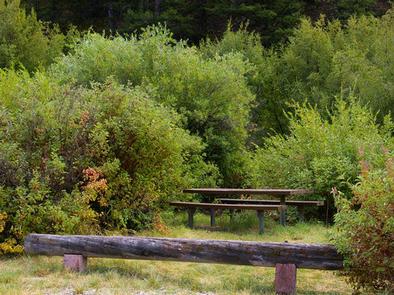
The campground offers 15 family sites, two of which are tent-only. Vault toilets are provided, but drinking water is not available. Roads and parking spurs within the campground are gravel.

Larger RVs and trailers may have difficulty maneuvering through the campground; please check individual site descriptions for maximum vehicle length. Additionally, campsites within this facility are considered very small and rustic. Driveways are narrow and surrounded by dense vegetation.

Natural Features

The campground in situated in dense stands of willow, which help shelter the campground from traffic noise. Montpelier Creek runs alongside the campground.

Nearby Attractions

Beautiful Bear Lake straddles the Utah-Idaho border and is within a 35-minute drive of the campground. Outdoor activities abound at Bear Lake, with endless boating, water skiing, jet skiing, scuba diving, swimming, hiking, biking, horseback riding and off-road vehicle riding opportunities. Sightseeing and scenic driving are popular activities as well.

Reservation

More from CampingHiking.net:

TWIN LAKES CABIN (AK), Alaska Campground Images, Info & Reservations

Directions Located on the north side of the Stikine River near Figure 8 Lake (Twin Lakes), in the Stikine-LeConte Wilderness. The cabin is 17 miles from Wrangell, accessible by shallow draft boat or float plane during moderate to high river levels. A minimum 16-foot river level is generally needed for

MCNAIR GROUP AREA, Illinois Campground Images, Info & Reservations

Directions From I-57, take Old U.S. Highway 50 west for 22 miles to the Dam East Entrance road. Turn north and continue through the four-way intersection to the McNair Group Area. Phone 618-594-5253 Activities BIKING, BOATING, CAMPING, FISHING, HIKING, WATER SPORTS, WILDLIFE VIEWING, SWIMMING SITE Keywords MCGR,DAM EAST REC AREA,SOUTH

OH RIDGE, California Campground Images, Info & Reservations

Directions Oh Ridge Campground is 350 miles north of Los Angeles and 150 miles south of Reno, Nevada. Take U.S. Highway 395 to its southern junction with Highway 158. Take 158 for 1 mile. Turn right on North Shore Drive. Go approximately 1 mile and turn left on Pine Cliff

LIVE OAK, California Campground Images, Info & Reservations

Directions From Bakersfield, take Highway 178 east to the town of Lake Isabella. From Lake Isabella take Highway 155 north approximately 6 miles to the Live Oak campground. Phone 760-376-1815 Activities CAMPING Keywords LIVO,LAKE ISABELLA,KERN VALLEY,SEQUOIA NF – FS Related Link(s) Rec Area Info & Images California State Road Conditions

ORLAND BUTTES, California Campground Images, Info & Reservations

Directions From Interstate 5, take the Black Butte Lake exit at Orland, CA. Travel west on County Road 200/Newville Road for 6 miles. Turn left on County Road 206 and drive 4 miles to the campground. Phone 530-865-4781 Activities BOATING, CAMPING, FISHING, HIKING, HUNTING, WILDLIFE VIEWING, SWIMMING SITE Keywords OBUT,BLACK

FAWN, California Campground Images, Info & Reservations

Directions From I-5 in Redding, take California State Highway 299 West to State Highway 3 at Weaverville. Go north on Highway 3 for 14.5 miles. Campground is on the right. Phone 530-275-8113 Activities BOATING, CAMPING, SWIMMING SITE Keywords FAWN,SHASTA-TRINITY -FS Related Link(s) Rec Area Info & Images California State Road