SUTTON CAMPGROUND, OR Campground Reservation, Info, Images, Map, Directions

SUTTON CAMPGROUND, Oregon Campground Images, Info & Reservations

Directions

From Florence, Oregon, take Highway 101 north 5 miles to the Sutton Campground turnoff and go one mile to the campground.

Phone

541-997-2715

Activities

BOATING, CAMPING, FISHING, HIKING, WILDLIFE VIEWING, SWIMMING SITE, BERRY PICKING

Keywords

SUTT,SIUSLAW NF – FS

Related Link(s)

Rec Area Info & Images

Oregon State Tourism

Forest Service Concessionaire

Oregon State Road Conditions

Overview

Sutton Campground is located just off the Pacific Coast in Oregon, 1.5 miles from Sutton Beach and 2 miles from Sutton Lake. Hiking is the most popular activity, but visitors also enjoy swimming in Sutton Creek, and fishing and boating on Sutton Lake.

Recreation

Hiking is Sutton Campground’s main draw. A number of trails provide access to nearby Alder Dunes and Sutton Lake. Wild berries, vibrant rhododendrons and picturesque sand dunes are located along the trails.

The Holman Vista Day Use Area and Holman Vista Trail are one mile west of the campground, providing an accessible viewing platform for memorable sunsets of the world’s largest the ocean.

Boating, canoeing and fishing are popular activities at Sutton Lake. Anglers cast for yellow perch, largemouth bass, cutthroat trout and stocked rainbow trout. A boat ramp is located 2 miles away.

Facilities

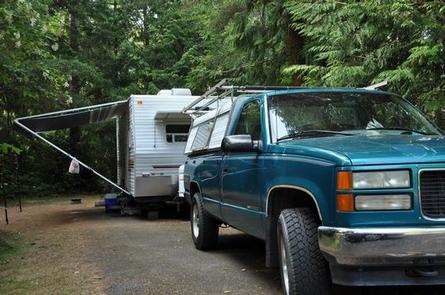
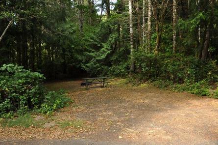
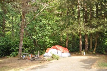
The campground offers single-family sites and group sites for overnight camping and day-use picnicking. Some sites offer electric hookups.

Picnic tables and campfire rings are provided, as are flush toilets and drinking water.

Natural Features

The campground is set among scenic coastal pine, Douglas-fir, spruce, wax myrtle and huckleberry trees within the Siuslaw National Forest. The Siuslaw extends across the lush forests of the coastal mountains to the Oregon Dunes and beaches of the Pacific Ocean.

Nearby Attractions

Oregon Dunes National Recreation Area begins 15 minutes south of the campground visitors will find 40 miles of wind-sculpted, shifting sand dunes. The area is known for its off-road opportunities, but it also offers accessible trails and beach access. Enjoy Darlingtonia State Natural Site, Heceta Beach, Sea Lion Caves and old town Florence, all within 10 miles of the campground.

Reservation

More from CampingHiking.net:

LOWER LITTLE TRUCKEE, California Campground Images, Info & Reservations

Directions From either east bound or west bound Interstate 80 in Truckee take exit 188, Highway 89 north to Sierraville. In aproximately 11 miles turn left into the campground. Phone (530) 994-3401 Activities CAMPING, FISHING, HIKING, HUNTING, MOUNTAIN BIKING, SCENIC DRIVE Keywords LOLI,TAHOE NF – FS Related Link(s) Rec Area

INDIAN TREES CAMPGROUND, Montana Campground Images, Info & Reservations

Directions From Sula, travel 6 miles south on Highway 93, then 1 mile southwest on Forest Road 729. Road to campground is gravel, but the campground and parking spurs are paved. Phone 406-821-3913 Activities BIKING, HISTORIC & CULTURAL SITE, CAMPING, FISHING, HIKING, HUNTING, SWIMMING SITE Keywords INDT,BITTERROOT NF -FS Related

CUMMINGS CABIN, Montana Campground Images, Info & Reservations

Directions The cabin is located 8.5 miles east of Lincoln, Montana and can be reached via Hogum Creek Road, which is approximately 6 miles east of Lincoln on Highway 200. Follow Hogum Creek Road to the junction of Black Diamond Road and Lower Hogum Creek Road. Lower Hogum Creek Road

WILSON NARROWS CABIN, Alaska Campground Images, Info & Reservations

Directions The cabin is accessible by float plane only. It is located approximately 44 air miles northeast of Ketchikan on the mainland, north of Wilson Arm. The cabin sits on the south end of Wilson Lake. This cabin is in a designated Wilderness area, and access by helicopter is illegal.

DRAKE PEAK LOOKOUT, Oregon Campground Images, Info & Reservations

Directions From the Lakeview Ranger District Office, travel 6 miles north on Highway 395, and turn right on Highway 140. Take Highway 140 east for 8 miles, then turn left on Forest Road 3615. Continue on Forest Road 3615 for 7.5 miles and turn right on Forest Road 019. Follow