SPEARHEAD POINT SHELTER, WI Campground Reservation, Info, Images, Map, Directions

SPEARHEAD POINT SHELTER, Wisconsin Campground Images, Info & Reservations

Directions

From Medford, travel north on State Highway 13 for 4 miles, then turn left (west) onto County Road M and continue for 7 miles. Turn right (north) onto County Highway E and continue about 8 miles, then turn right (east) onto Forest Service Road 1563 and continue for about 1 mile. Turn right (east) onto Forest Service Road 106 and look for the campground entrance sign at the top of the hill.

Phone

715-784-4875

Activities

BIKING, BOATING, CAMPING, FISHING, HIKING, WILDLIFE VIEWING, SWIMMING SITE

Keywords

SPOS,CHEQUAMEGON-NICOLET NF – FS

Related Link(s)

Rec Area Info & Images

Wisconsin State Tourism

Wisconsin State Road Conditions

Overview

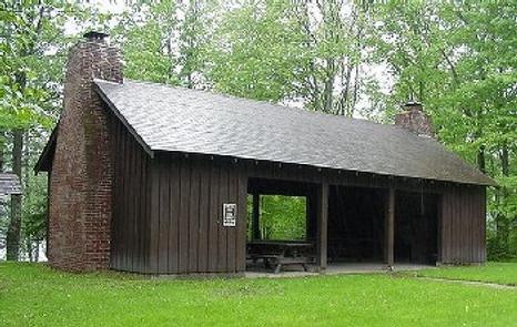
Spearhead Point Shelter is a day-use picnic site for large groups. It is located in one of the most popular areas surrounding Mondeaux Flowage in northern Wisconsin. Nearby, visitors can access the lake and numerous trails.

Recreation

Boating, swimming and fishing are popular activities. Anglers can expect to find a variety of species, including pike, largemouth bass and bluegill. Boats with and without motors are allowed on the lake, however the lake is quite shallow in some areas. A portion of the Ice Age National Scenic Trail is easily accessed from the campground. The trail is open to hiking and wanders 1,200 miles along the edge of a historic glacier that once covered the state of Wisconsin and much of North America.

Facilities

The accessible picnic shelter can accommodate up to 30 people. It is equipped with picnic tables and grills. Two stone fireplaces are available inside the shelter. Accessible vault toilets and drinking water are also provided.

Overnight camping is not allowed at the shelter but is available at adjacent Spearhead Point Campground.

Natural Features

The shelter is located within the Spearhead Point Campground at an elevation of 1,140 feet. Tall trees surround the shelter, which is nestled along the western shore of 411-acre Mondeaux Flowage.

Nearby Attractions

The city of Westboro is about 10 miles away.

Reservation

More from CampingHiking.net:

IDLEWILD, Oregon Campground Images, Info & Reservations

Directions From Burns, OR: Travel northeast toward Vale 2.8 miles on US Highway 20 to the junction with US Highway 395, turn left onto US Highway 395 and head north. Follow US Highway 395 for approximately 14.6 miles to the junction with Forest Road 2820. Turn right and continue on

VICTORIA CAMPGROUND, Georgia Campground Images, Info & Reservations

Directions From I-575, take exit 11 and turn west onto Sixes Road. After 2.5 miles turn left on Bells Ferry Road and follow the signs to the campground. Physical address: 937 Victoria Landing Drive Woodstock, GA 30189 Phone 678-721-6700 Activities CAMPING, FISHING, SWIMMING SITE Keywords VICT,ALLATOONA LAKE,ALLATOONA LAKE Related Link(s)

WHITETAIL CABIN, Montana Campground Images, Info & Reservations

Directions From Ashland, Montana, take Highway 212 east for approximately 5 miles to East Fork Otter Creek Road. Turn northeast onto East Fork Otter Creek Road and travel 12 miles to Whitetail Cabin. Phone CALL FOR COMBINATION PRIOR TO YOUR STAY – M-F 8:00 TO 4:30 CALL 406-784-2344. AFTER HOURS

NORTH FORK (CA), California Campground Images, Info & Reservations

Directions From east bound Interstate 80 take exit 158A or west bound Interstate 80 take exit 158B south to Emigrant Gap. After exiting the interstate take a right on Texas Hill Road towards Emigrant Gap. Continue on Texas Hill Road for about 6.5 miles and turn right into the campground.

WOODRING CAMPGROUND, Georgia Campground Images, Info & Reservations

Directions From Atlanta, take I-75 north to Exit 293; follow Highway 411 north. Turn right on Highway 136, then left on old Highway 411. Turn right on Highway 282/76. Campground is located 4.5 miles off Highway 282. From Ellijay, GA, take Highway 282/76 west for 11 miles to the access

WAR EAGLE CAMPGROUND, Arkansas Campground Images, Info & Reservations

Directions Take Highway 412 East from Springdale and for about 8 miles. Turn left on Nob Hill Loop, then continue onto County Rd 95/War Eagle Blacktop Rd and travel about 3 miles. Turn left onto War Eagle Park Road, which is the entrance of the Park. Phone 479-750-4722 Activities BOATING,