PIONEER PARK, WA Campground Reservation, Info, Images, Map, Directions

PIONEER PARK, Washington Campground Images, Info & Reservations

Directions

From downtown Newport, travel east on U.S. Highway 2 for 0.75 miles. Immediately after crossing the Pend Oreille River bridge, turn left on LeClerc Road and travel 2 miles north to the campground.

Phone

509-447-7300

Activities

BOATING, CAMPING, FISHING, HIKING

Keywords

PIOR,COLVILLE NF – FS,PIONEER

Related Link(s)

Rec Area Info & Images

Washington State Road Conditions

Washington State Tourism

Overview

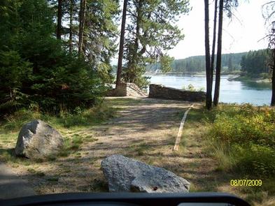
Pioneer Park Campground is located in northeast Washington on the Pend Oreille River. Visitors enjoy hiking, fishing, boating and swimming. The campground’s proximity to the city of Newport provides urban entertainment opportunities as well.

Recreation

The Pioneer Park Heritage Trail, a short trail that highlights the history of the Kalispel Tribe, is a favorite attraction in the campground. Twelve interpretive displays are dispersed along the 0.3-mile boardwalk trail, which boasts scenic views of the river below.

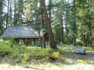
Excellent bass and trout fishing can be found in the Pend Oreille River. A boat ramp, picnic shelter and swimming area are located on-site.

Facilities

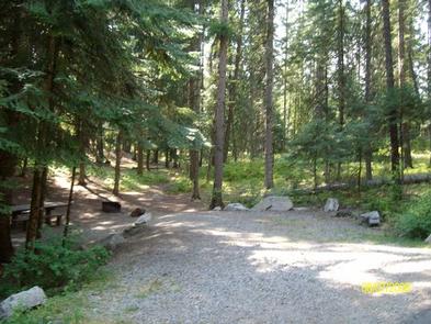
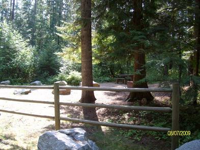
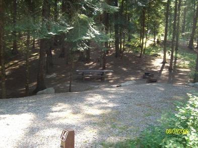
Each campsite is equipped with a picnic table, campfire ring and tent pad. Amenities include vault toilets and drinking water. Gravel parking spurs can accommodate any RV size.

Natural Features

The campground is surrounded by groves of ponderosa pine, white pine, hemlock and grand fir trees, and sits at an elevation of 2,000 feet. Campsites are spacious and shady, with an understory of wild roses and thimbleberry.

Pioneer is situated at the southern edge of Colville National Forest, near the Idaho border. The forest spans 1.1 million acres and encompasses the Okanogan, Kettle River and Selkirk Mountain Ranges.

Nearby Attractions

The city of Newport is conveniently close for a restaurant outing or summer entertainment. Children will enjoy the Little People’s Park in town.

Reservation

More from CampingHiking.net:

RED BLUFF CAMPGROUND, Missouri Campground Images, Info & Reservations

Directions From St. Louis, Missouri, take I-44 west to Cuba. Continue on Highway 19 south to Cherryville. Take 49 south to Highway V, turn left to Davisville and travel approximately 1 mile and turn left into the campground. Phone 573-743-6042 Activities CAMPING, FISHING, WATER SPORTS Keywords REDB,MARK TWAIN NF -FS

SANDERS COVE, Texas Campground Images, Info & Reservations

Directions From Paris, TX, take HWY 271 north 12 miles to FM 906 W and follow it 1 mile to CR 35920. Turn left into the park following signs. Phone 903-732-4955 Activities BIKING, BOATING, CAMPING, FISHING, HIKING, HUNTING, SWIMMING, WATER ACTIVITIES, WATER ACCESS, ACCESSIBLE SWIMMING Keywords SACV,PAT MAYSE LAKE,SANDERS CREEK,SANDERS

BALD RIDGE CREEK, Georgia Campground Images, Info & Reservations

Directions From Atlanta, GA, take SR 400 N to Exit 16, turn right on Pilgrim Mill Rd., turn right on Sinclair Shoals Rd., turn left on Bald Ridge Rd. Follow signs into campground. Phone 770-889-1591 Activities BIKING, BOATING, CAMPING, FISHING, SWIMMING SITE, KAYAKING, WATER ACCESS Keywords BALR,LAKE LANIER,BALD RIDGE,BALL RIDGE,LAKE

WILLIS KNOB HORSE CAMP, Georgia Campground Images, Info & Reservations

Directions From Clayton, Georgia, take Warwoman Road east for about 12 miles. Turn right on Forest Service Road 157 and continue for 2 miles to the campground on the left. Phone 706-754-6221 Activities CAMPING, HORSEBACK RIDING, HUNTING, WILDLIFE VIEWING, HORSE CAMPING Keywords KNOB,CHATTAHOOCHEE-OCONEE NF – FS,HORSE CAMP Related Link(s) Rec