OAK PARK (WRIGHT PATMAN LAKE), TX Campground Reservation, Info, Images, Map, Directions

OAK PARK (WRIGHT PATMAN LAKE), Texas Campground Images, Info & Reservations

Directions

From Texarkana, take U.S. Highway 59 south for approximately 12 miles. Turn right at the sign for Wright Patman Lake. Follow the park road to the dam; turn left and proceed to the next intersection. Turn left again, and follow the road to the park.

Phone

903-838-8781

Activities

BOATING, FISHING, PICNICKING, WILDLIFE VIEWING, DAY USE AREA, SOFTBALL FIELDS

Keywords

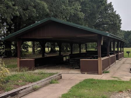
OAKP,Model Airplane Flying Field,Pavilion below the dam,WRIGHT PATMAN DAM,OAK PARK (WRIGHT PATMAN LAKE)(TX)

Related Link(s)

Rec Area Info & Images

Texas State Road Conditions

Texas State Tourism

Overview

Oak Park is a day use area located just below the dam on Wright Patman Lake in northeastern Texas. Its picnic shelter and ball fields make it a great location for larger groups and special events.

Recreation

This facility is a relaxing and spacious location for group gatherings and picnics. Wright Patman Lake hosts a wide range of recreational activities to allow visitors to get outdoors and enjoy the area, including boating, fishing, hunting, hiking, picnicking and wildlife viewing.

Several boating, fishing and swimming facilities can be accessed in nearby parks around the lake. Anglers enjoy fishing for bass, catfish, crappie and sunfish.

A model airplane flying field is located next to the park.

Facilities

Oak Park offers one group day-use picnic shelter with water and electric hookups. Several family picnic sites are available on a first come, first served basis. A swing set, sand volleyball court and baseball diamond are located next to the shelter. No swim beach is available in the park.

Natural Features

Oak Park is named for its large oak trees that create a peaceful, nostalgic setting and shade for picnickers. Though it is not directly on the waterfront, the shelter is a short walk or drive from the scenic shoreline.

The U.S. Army Corps of Engineers manages approximately 55,000 acres of public forestland around the lake, providing habitat for wild turkey, bobwhite quail, squirrel, white-tailed deer, migrating bald eagles, pelicans and ducks and other waterfowl. Some poisonous snakes inhabit the area.

Nearby Attractions

The Texarkana region is full of activities such as shopping, movies, restaurants and local historical sites. Shreveport, Louisiana offers river boat gambling, horse races and numerous festivals, including the Four State Fair and Rodeo and the Jump, Jive and Jam Festival.

Reservation

More from CampingHiking.net:

EAST FORK CALIFORNIA, California Campground Images, Info & Reservations

Directions From Bishop or Mammoth Lakes, California, follow U.S. Highway 395 (about 30 miles north of Bishop). Take the Tom’s Place exit and go 6 miles on Rock Creek Road. Phone 760-935-4825 Activities CAMPING, FISHING, HIKING, HORSEBACK RIDING, PICNICKING, WILDLIFE VIEWING Keywords EASF,INYO NF – FS Related Link(s) Rec Area

INDIAN HENRY, Oregon Campground Images, Info & Reservations

Directions From Estacada, Oregon, travel east on Highway 224 for 24 miles to the campground. Phone 503-630-5721 Activities CAMPING, FISHING, HIKING, WATER SPORTS, DAY USE AREA Keywords INDH,MT. HOOD NF – FS Related Link(s) Rec Area Info & Images Oregon State Tourism Forest Service Concessionaire Oregon State Road Conditions Overview

MOUNTAIN OAK, California Campground Images, Info & Reservations

Directions From Wrightwood, CA, take State Rt. 2 west 2.4 miles to Palmdale/Jackson Lake sign (County Rt. N4/Pines Highway). Turn right onto Rt. N4 and go 3.1 miles to campground sign. Turn right into campground. Phone 760-249-3526 Activities BOATING, CAMPING, FISHING, HIKING, WILDLIFE VIEWING, SWIMMING SITE, CANOEING, BIRDING, SCENIC DRIVE

THUMB BUTTE, Arizona Campground Images, Info & Reservations

Directions From Phoenix, Arizona: Traveling Northbound on I-17 take Exit 262 onto Hwy 69 North to Prescott and cointnue on Hwy 69 for 41 miles. Once you have arrived in Prescott, continue to go west on Hwy 69 which turns into Gurley St., which then becomes the Thumb Butte Road,

MANISTIQUE – RAPID RIVER DISPERSED CAMPSITES, Michigan Campground Images, Info & Reservations

Directions All driving directions are listed by lake. Please check campsite details. Phone 906-474-6442 Activities BIKING, BOATING, CAMPING, FISHING, HIKING, HORSEBACK RIDING, WATER SPORTS, WILDLIFE VIEWING, DAY USE AREA, SWIMMING SITE Keywords Dispersed campsites,Manistique,Rapid River,lyman lake,swan lake,bass lake,bear lake,camp cook,carr lake,chicago lake,clear lake,crooked lake,east lake,gooseneck lake,ironjaw lake,jackpine lake,lake nineteen,leg lake,little